Patrisha Wells and David Cardella, Esri, recently hosted a free, online training intro on developing with ArcGIS for iOS. Free, online training is a fabulous way to stay up on technology and hear/see first-hand from the development team – I highly suggest it!
Introduction to ArcGIS for iOS – Recall using your ArcGIS for the following: local, enterprise, and cloud. Now you can extend your enterprise GIS to the iOS environment.
About – The ArcGIS API for iOS enables you to build applications that utilize the powerful mapping, geocoding, geoprocessing, and custom capabilities provided by ArcGIS Server using Objective C and deploy them to Apple iPhone, iPod Touch, and iPad devices. The API includes native Objective C libraries, templates, and samples that can be used within the Xcode Integrated Development Environment (IDE). Source – http://resources.arcgis.com/content/arcgis-iphone/api
So, why consider mobile?
- access to real time information
- route and navigate using maps
- get updated information faster
- maintaining your operational data and wireless synch
The team offered up a sample Demo showing a mobile app on iPhone with a Tweets layer that shows location of real-time tweets nearby (this using an example of being at GeoInt 2010 event in N’orleans) – indeed a popular idea for a mobile data layer!
ArcGIS for iOS is for:
- consumers of enterprise GIS
- sonsumers of community mapping
- GIS developers
- Esri biz partners
ArcGIS for iOS is an application (access online content) and an API (enable you to build custom apps using native Objective-C API) – for touch, iPad, iPhone. The ArcGIS iOS app is the first iOS app and supports the 3 main devices – not sclaed to fit iPad but built specifically for the iPad device. Maps from ArcGIS.com or your ArcGIS Server (10+)

Sample Map Layer using iOS App
What can the app do?
- display and navigate maps
- find places and address locations
- identify features
- query map features
- new – data collection
- collect points, lines and area features and edit these features
Using your data
- Create a map service
- publish as a service using ARcGIS server
- create webmaps locally on your server or on ArcGIS.com
- Access the map via ArcGIS for iOS
- data is cached locally
NOTE: Android tools are coming soon as well as Windows Phone developer tools (in public Beta currently)
About The ArcGIS API for iOS:
- Objective-C API for developers
- develop map apps from scratch or embed existing functionality
- you get: API package (via arcgis resource center), refernce help, community resources (code sharing), sample code.
- API package – integrates in Xcode (MAC) includes templates and documentation
- provided webmaps are provided in WGS84 – Web Mercator
- map services – dynamic, cahced, Bing Maps, OSM
For ideas and tips on getting started it is suggested you research or search out the following resources:
- Apple’s iOS SDK 4.0
- ArcGIS API for iOS
- technologies used – Objective-C, cocoa touch (API for finger-based gestures), iOS SDK (enable use of iOS GPS, camera, and other functionality)
The road to deploment:
- Download ArcGIS API for iOS – Develop your app – deploy externally or internal.
- External deployment involves submission to Apple iTunes or via enterprise agreement via Apple (to restrict to corporate users)
- Note: Keep in mind that you must attribute Esri for the API, Data and use the Esri logo in your app
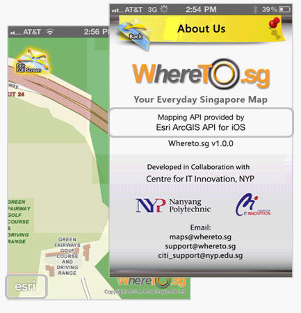
All apps must attribute Esri
Moving forward:
- Look for incremental updates – 2-3 mo
- Improved UI
- full feature editing
- offline use
- routing
- legend
- bookmarks
- more
Requirements:
Compatible with iPhone, iPad, and iPod touch devices
Requires Apple iOS version 3.1.2 or later
Intel-based Macintosh running Leopard (OS X 10.5) or Snow Leopard (OS X 10.6).
An iPhone, iPad, or iPod Touch is recommended for testing the user experience/interface within your application.
Suggested Links & Resources:
-
About – http://www.esri.com/software/arcgis/ios/develop.html
- Press – http://www.esri.com/news/releases/10_4qtr/arcgis-api-ios.html
-
Resource Center – http://resources.arcgis.com/content/arcgis-iphone/api
& resources.arcgis.com/content/arcgis-ios
-
Forum – http://forums.arcgis.com/forums/78-ArcGIS-for-iPhone
-
Webinar – http://forums.arcgis.com/forums/78-ArcGIS-for-iPhone
-
DevGeo Silicon Valley – http://www.esri.com/events/devgeo/index.html
-
Demo Video – http://www.esri.com/software/arcgis/ios/demos.html
-
iOS App – http://www.esri.com/software/arcgis/ios/app.htmlApple Dev Center http://developer.apple.com/devcenter/ios/index.action
-
See also stanford iphone application development – iTunesU http://itunes.stanford.edu/