Trimble Customer Story – Trimble GNSS Equipment Performs Multi-Purpose Field Mapping – By day, the GIS Technology Vehicle supports infrastructure construction, asset maintenance, and operations; by night, the vehicle serves as a mobile command center for public safety and emergency operations.
PROJECT: Trimble GNSS Equipment Performs Multi-Purpose Field Mapping
PROJECT DATE: Deployed in 2009
Monroe County’s many wooded wetland areas. Winter snows covered the maze of frozen marshes and ponds making it dangerous for law enforcement to follow in pursuit. The suspect’s body was found in the marsh the next spring. Officials in the county’s Department of Environmental Services believed the manhunt could have ended differently if their vast GIS and GNSS resources had been put into the hands of public safety personnel onsite. The idea for a mobile GIS vehicle was born.
Monroe County, NY, is home to 750,000 residents living in 19 towns, 10 villages and the state’s third largest city, Rochester. More than a decade ago, the county launched an enterprise GIS predicated on the concept of two-way data sharing among the county and local governments. From the start, Monroe embraced Trimble GNSS technology for the collection of asset information to populate the GIS.
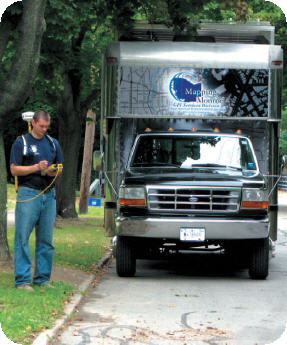
Today, the Department of Environmental Services’ GIS Division supports nearly every county office with mapping services. The department came up with the idea to improve access to data collection and GIS capabilities for the entire 733-square mile county by taking the services on the road. Eastman Kodak of nearby Rochester made the concept a reality with the donation of a van.
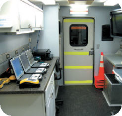
Monroe turned the van into a GIS Technology Vehicle by installing three workstations, ruggedized laptops, a 36-inch plotter, printers, a SmartBoard, big-screen monitor, radios, and wireless communications equipment. The onboard computers use this communications link to access the enterprise GIS as well as the county’s GNSS base stations. During asset inventories, GIS feature layers can be updated from the field with data uploaded directly from the mobile GNSS receivers carried in the van. Data can also be broadcast to the county’s Emergency Operations Center (EOC).
The GIS Division rotates GNSS equipment from its main office to the van, but it usually carries the Trimble® GPS Pathfinder® Pro XR receiver backpack systems and newer GPS Pathfinder ProXH™ receivers. These mapping receivers are used alongside Trimble GeoXT™ GNSS handhelds. The county has established three base stations including two Trimble R8 GNSS receivers. The survey rovers typically receive real-time correction in the field through cell phone connection, while the mapping receivers have their data post-processed with Trimble GPS Pathfinder Office software in the van. In both cases, the GNSS data has been differentially corrected before it reaches the enterprise GIS. During the day, the vehicle can be found onsite at any major engineering and construction projects, generating GIS maps of where utility assets and property boundaries are located. As construction progresses, crews capture as-built data with the GNSS receivers to instantly update the enterprise GIS. Accurate records of newly installed or relocated infrastructure are never more than a few hours out of date.
When the vehicle is not located onsite at a construction or repair project, the GIS Division dispatches it throughout the county for asset mapping using the Trimble GeoXT handheld units with integrated GNSS. The vehicle has also been used extensively during an ongoing county-wide project to extend fiber optic cables to all of the town and hamlets. The GIS lets the field crews know precisely where parcel boundaries are so that trenching on private property can be avoided whenever possible. And if field crews must enter a property, they can knock on a homeowner’s door and address them by name when making the request—thanks to the GIS database.
Steve Schwartzmeier, Senior Operations Manager for the Department of Environmental Services, likens the vehicle to a superhero that has one identity by day and another on nights and weekends.
"It’s used day-to-day for just about any mapping service you can imagine [related to] county maintenance, operations and construction," said Schwartzmeier."Then at night, we serve a completely different audience bringing a full complement of mapping capabilities to fire, police, and Emergency Management folks."
As if the day job weren’t enough, the GIS Technology Vehicle is often requested for service by the Monroe Director of Public Safety. These duties are typically divided into emergency and non-emergency assignments. The majority of the planned, non-emergency activities involve festivals and other public events that are likely to draw large crowds. The vehicle plays a critical role in coordinating public safety logistics in these situations.
 At an annual air show, for example, the vehicle arrives in advance and its crew maps out the locations of vendor booths, power sources, and staging areas. Public evacuation routes as well as emergency vehicle ingress/ egress lanes are also mapped in case an aircraft were to crash in the area. These points are added as layers to the GIS, and maps are printed in the van for distribution to the various public safety personnel, who typically come from across the county to work the show.
At least once a month, the GIS Technology Vehicle is called to the scene of a rapidly evolving emergency. In one recent example, an escapee from a detention facility was eluding the state police, and the van was brought in. It arrived just as the police lost their communications link to the EOC. They quickly moved to the GIS van for onsite command operations. GIS maps and color air photos of the area were printed onboard and circulated among the officers for use on foot and in the air, resulting in an incident-free apprehension—and a more positive outcome than the situation three years earlier that first inspired the van’s creation.
"The hard copy maps that we provided from our large-format plotter gave the officers a good feel for the surrounding terrain, and they made an apprehension within an hour or two," said Scott McCarty, Operations Manager for the GIS Division.
The GIS Technology Vehicle is a resounding success, now in great demand across the county. At the end of the day (or night), its greatest benefit to the county is that it puts information into the hands of experts where they need it, when they need it. In doing so, the van has saved thousands of personnel hours both in the field and in the office. And it’s put potentially life-saving information at the disposal of public safety personnel.
"We are able to get information out into the field," said Schwartzmeier, "and good information supports better decision making."
EQUIPMENT USED ON THESE PROJECTs INCLUDES:
- Trimble R8 GNSS receiver
- Trimble GPS Pathfinder ProXH receiver
- Trimble GeoExplorer 3000 Series GeoXT handheld
- Trimble GPS Pathfinder Pro XR receiver
- Trimble GPS Pathfinder Office software
- Trimble Business Center software
- Esri ArcGIS software
- Esri ArcSDE server
PROJECT HIGHLIGHTS
- GeoXT handheld units in the vehicle enable field crews to map and upload as-built infrastructure into county-wide enterprise GIS from the site of construction projects.
- GNSS and GIS capabilities in the vehicle provide direct support to public safety personnel onsite at both planned events and emergency incidents.
- GIS maps printed in the van at the scene of an emergency gives law enforcement personnel better familiarity with surrounding terrain in safety-oflife situations.
- The County estimates the van and its GIS and GNSS equipment have saved thousands of personnel hours for surveyors, clerks, assessors, engineers, and other field technicians as well as public safety personnel.