GIS user technology news

News, Business, AI, Technology, IOS, Android, Google, Mobile, GIS, Crypto Currency, Economics

  • Advertising & Sponsored Posts
    • Advertising & Sponsored Posts
    • Submit Press
  • PRESS
    • Submit PR
    • Top Press
    • Business
    • Software
    • Hardware
    • UAV News
    • Mobile Technology
  • FEATURES
    • Around the Web
    • Social Media Features
    • EXPERTS & Guests
    • Tips
    • Infographics
  • Blog
  • Events
  • Shop
  • Tradepubs
  • CAREERS
You are here: Home / News / Maps, Cartography, and awesome Data Visualizations / Blue Raster – Suitability Mapper: Finding Sustainable Palm Oil Sites

Blue Raster – Suitability Mapper: Finding Sustainable Palm Oil Sites

May 20, 2014 By Editor

The power of GIS as a tool to help manage our planet’s natural resources is limited only by the insightfulness of our questions. Fortunately, more timely and detailed data becomes available every year, so we are free to ask an ever-wider range of questions, such as:

  • In relation to agriculture, what factors affect our ability to sustainably produce crops, and how do these factors change across the landscape?
  • Where should agriculture expand, and where should it retract?
explore_maps

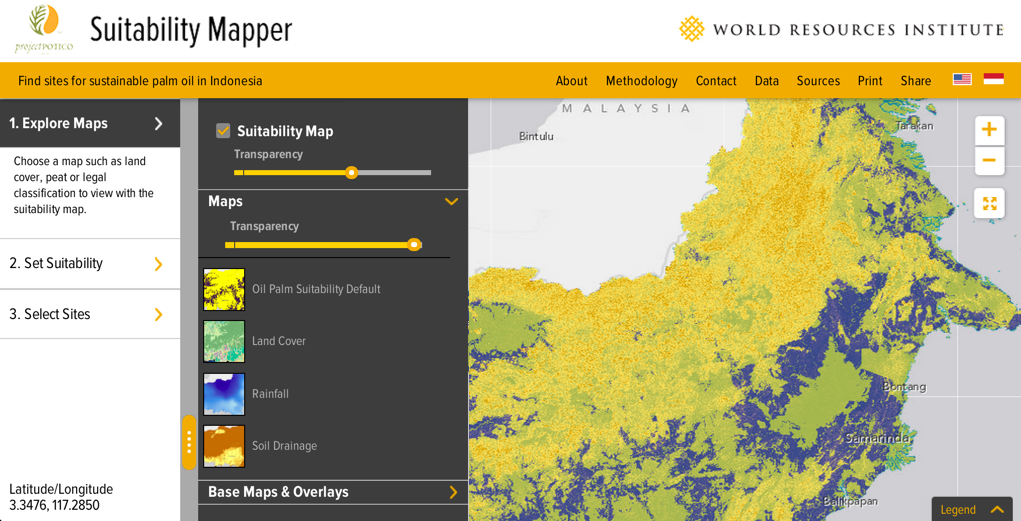
Blue Raster, along with partners World Resources Institute (WRI) and Sekala, has developed an interactive web application allowing users to customize criteria for sustainable agriculture and find sites for sustainable palm oil across Indonesia.

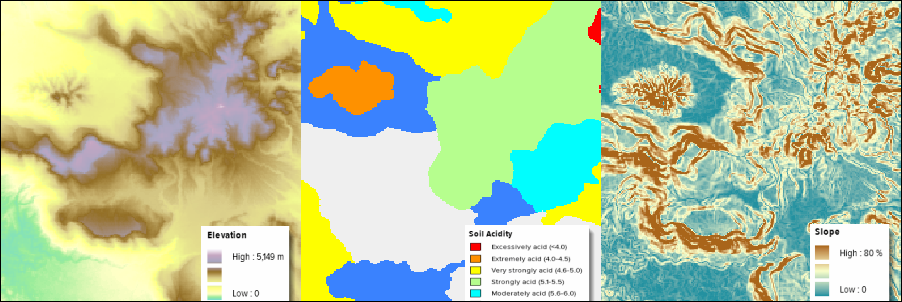
Upon entering the Suitability Mapper, users visualize various layers superimposed on the Indonesian landscape including elevation, hill slope, rainfall, and soil acidity. WRI provides a two-color layer showing the distribution of areas deemed “potentially suitable” (purple) and “unsuitable” (yellow) for sustainable palm oil production.
suitability layers

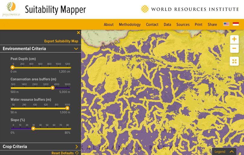
Taking analysis a step further, the user can adjust the criteria for this suitability layer by adjusting controls linked to each palm oil variable. In the screenshot below, I have adjusted the suitability analysis to increase the mandatory distance from conservation areas and water resources. With my custom analysis complete, I can use drawing tools to summarize the results for a specific area. Results include the area’s legal status, amount of suitable area, distance from nearby roads, legal status, and whether an oil palm concession already exists in the location.
custom_suitability

The Suitability Mapper was built on top of Esri’s ArcGIS Server and ArcGIS API for JavaScript. Using the Image Extension for ArcGIS Server, we are able to analyze and compute accurate suitability maps in realtime based on user-supplied criteria. Instead of investing large amounts of time in software development and maintenance, we were able to use the out-of-the-box features of Esri’s Image Extension for ArcGIS Server to achieve the goals of the project. This platform  will also make it easier to add more and better data as it becomes available, to continually improve our analysis, inform key stakeholders, and make better decisions.  

Suitability Mapper is part of the Global Forest Watch platform which has many new features coming soon with the launch of its Commodities analysis tool.  Stay tuned for more information and launch dates soon


Source: http://www.blueraster.com/ blog/2014/05/13/suitability- mapper-finding-sustainable- palm-oil-sites/

Filed Under: Maps, Cartography, and awesome Data Visualizations Tagged With: and awesome Data Visualizations, Blue Raster - Suitability Mapper: Finding Sustainable Palm Oil Sites, Cartography, Maps, News

About Editor

Glenn is a geographer and a GIS professional with over 20 years experience in the industry. He's the co-founder of GISuser and several other technology web publications.

Top Press

The Global Expansion of Aueshah: A New Era of High Jewelry

April 11, 2026 By GISuser

KARACHI, PAKISTAN. The international luxury market is experiencing a profound shift. Consumers are increasingly rejecting mass-produced goods in favor of rarity, authenticity, and emotional depth. … [Read More...]

State of Data Science Report – AI and Open Source at Work

September 10, 2025 By GISuser

AI and Open Source at Work … [Read More...]

Topcon Announces Landmark Expansion of Topnet Live Network Across USA

January 26, 2025 By GISuser

LIVERMORE, Calif.---Topcon Positioning Systems has announced a significant expansion of its Topnet Live reference station network, introducing 200 new geodetic stations strategically positioned across … [Read More...]

Space Flight Laboratory (SFL) Announces Launch and Deployment of NorSat-4 Maritime Monitoring Microsatellite

January 19, 2025 By GISuser

Seventh Satellite Developed by SFL for Norway … [Read More...]

HERE and BMW Group extend partnership on AI-powered mapping system

January 8, 2025 By GISuser

HERE and BMW Group extend partnership on AI-powered mapping system for automated driving and enhanced road safety … [Read More...]

SFL Missions Inc. Confirms Successful Deployment of Six HawkEye 360 Radio Frequency Detection Satellites with Advanced Capabilities

October 27, 2026 By GISuser

MĀHIA, New Zealand, 26 October 2026 – SFL Missions Inc. today confirmed the successful deployment of six radio frequency (RF) detection and geolocation satellites for HawkEye 360 … [Read More...]

Canadian-Built RoadEng 12 Uses AI to Find the Best Location for New Resource and Rural Roads

October 17, 2026 By GISuser

Vancouver, BC, Canada, October 15, 2026 – North Vancouver-based Softree Technical Systems today released RoadEng Version 12, used in more than 75 countries to locate and design … [Read More...]

Beyond the Map: How AI Image and Video Generation Is Changing Geospatial Communication

October 14, 2026 By GISuser

Ask anyone who has shipped a GIS project what the hardest part was, and the answer is rarely the spatial analysis. It is almost always the communication. A site suitability … [Read More...]

From Maternity to Everyday Wear: Building a Wardrobe That Grows With You

October 14, 2026 By GISuser

When I think about maternity clothing, I feel the biggest mistake is buying too many things at once. During pregnancy, your body keeps changing, and something that fits well today … [Read More...]

eMMC 5.1 Explained: Features, Performance, and Applications in Modern Devices

October 14, 2026 By GISuser

Storage technology is an essential part of modern computing, influencing how devices store information, launch applications, and manage everyday workloads. Although … [Read More...]

Copyright gletham Communications 2015 - 2026

Go to mobile version