GIS user technology news

News, Business, AI, Technology, IOS, Android, Google, Mobile, GIS, Crypto Currency, Economics

  • Advertising & Sponsored Posts
    • Advertising & Sponsored Posts
    • Submit Press
  • PRESS
    • Submit PR
    • Top Press
    • Business
    • Software
    • Hardware
    • UAV News
    • Mobile Technology
  • FEATURES
    • Around the Web
    • Social Media Features
    • EXPERTS & Guests
    • Tips
    • Infographics
  • Blog
  • Events
  • Shop
  • Tradepubs
  • CAREERS
You are here: Home / Blog / 5things / 5 More Cool Things Spotted at ESRIUC

5 More Cool Things Spotted at ESRIUC

July 22, 2013 By Editor

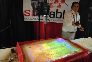
It’s been a bit since I rolled out an edition of “5 Cool Things“, so I figured since I saw so many cool things at ESRIUC this would be a perfect chance to pen an update! Enter The Sand Table – This was one of those “WOW” displays that attracted a crowd and left you thinking to yourself, “I gotta get me one of those!”  The company, Simtable, provides digital sandtables to the wildfire, emergency management, defense and urban security communities. Combining existing GIS data with next generation agent-based modeling and ambient computing SimTable provides a straightforward easy to use approach in incident response and training. Customized models of communities and populations provide a truly interactive experience in all-hazards simulations. The demo showed us how the sand on the table (think kids sandbox) could be moved around and shaped to model a 3D environment, then a series of map layers were projected onto the sand resulting in a very realistic environment to better grasp the situation. What was really cool was the ability to then light the sand on fire with a lighter and then view a real model of the spread of the wildfire based on various environmental and geographic conditions (wind, slope, aspect, etc…) It truly was impressive! 2013ESRIUC 179

See 5 Cool things at ESRIUC HERE

Filed Under: 5things

Editor’s Picks

Keep the UAV Devices Away – Create and Register Your Own No Fly Zone

Orbit GT supports LasZip for LAS 1.2 and LAS 1.4

Blue Marble Announces Advanced LiDAR Option for the Global Mapper SDK

Infographic – The History of the iPhone

See More Editor's Picks...

About Editor

Glenn is a geographer and a GIS professional with over 20 years experience in the industry. He's the co-founder of GISuser and several other technology web publications.

Recent Industry News

The Future of Competitive Gaming: Why DMA Technology is the Ultimate Performance Edge

June 24, 2026 By GISuser

Milwaukee M18FHZ-0 Hackzall Reciprocating Saw – For hardcore cutting in a compact size

June 19, 2026 By GISuser

How Enterprises Are Using AI to Automate 80% of Customer Interactions With Voice Agents

June 16, 2026 By GISuser

Why On Cloud Shoes Are Worth the Price in Mexico

June 16, 2026 By GISuser

Hot News

State of Data Science Report – AI and Open Source at Work

HERE and AWS Collaborate on New HERE AI Mapping Solutions

Virtual Surveyor Adds Productivity Tools to Mid-Level Smart Drone Surveying Software Plan

Categories

Copyright gletham Communications 2015 - 2026

Go to mobile version