Airspace Link Receives Esri’s ‘Analytics to Insights’ Award at the Esri Partner Conference for Exceptional Achievement in Delivering Analytics and Insights to Users Through Location Intelligence
DETROIT, March 7, 2022 /PRNewswire/ — Airspace Link, a leading drone data and software company, received the Insights to Analytics Award at the 2022 Esri Partner Conference (EPC) held in Palm Springs, California March 5–7, 2022. This award was presented to the Airspace Link team for recognition of product excellence of their AirHub® Platform in leveraging Esri ArcGIS Insights technology in delivering analytics and insights to users through location intelligence.
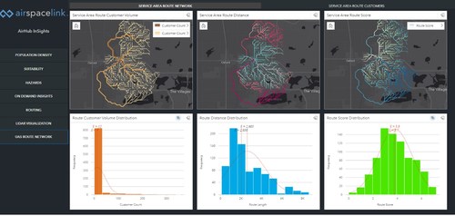
State and Local Government partners and Commercial Operators have described Airspace Link’s AirHub Platform as the “Smart Maps for Drones” but with the added complexity that the “roads” for drones in the sky don’t exist yet. AirHub leverages the Esri Technology for ground-risk data, layers on localized authoritative data, the latest FAA rules and regulations, and 3rd party data sets to build digital infrastructure, including safe and optimal routes, for every type of drone operation.
The Insights to Analytics Award from Esri highlights AirHub’s unique capability to support high performance modelling and analytics across curated data sets. These analytics are combined to answer the tough questions drone operators and government stakeholders are facing like where the population will be on the day and time of a planned operation or if a corridor supports a given community equitably, for example. AirHub is “State and Local Government Specialty” certified within the ArcGIS Marketplace and is available as “Release Ready” for Esri users.
Esri is the global leader in location intelligence with a network of over 2700 partners around the world. The award winners are organizations that have demonstrated innovative and creative ways to solve complex problems by using Esri’s ArcGIS software and those who have done exceptional work in advancing geographic information systems (GIS) technology. Airspace Link was one of 26 Esri partners that received an achievement award at the conference.
“Esri congratulates Airspace Link on their 2022 EPC award in recognition of their innovative work in bringing Analytics to Insights, leveraging ArcGIS software,” said Robert Laudati, Director of Global Partners and Alliances at Esri. “We are proud to partner with Airspace Link to foster the use of GIS technology in support of our mutual customers.”
“We’re honored that among the 2800 partners at Esri globally, we were recognized among the 26 partners receiving achievement awards. We’re excited to scale this award-winning technology to more geographies and use cases across the drone ecosystem as the rules and regulations in the space evolve to expand the use cases. We’re at an inflection point where we’ll go from drones being on the fringe to becoming ubiquitous, supported by technologies like AirHub that provide these advanced insights and analytics to prove out the safety and efficacy of drone flights at scale” said Michael Healander, Co-Founder and CEO of Airspace Link.
The Airspace Link team, founded in 2018, grew rapidly in 2021 alone from 17 to 34 employees, citing plans for continued exponential growth in 2022 and beyond to meet the industry demand and perpetually advance the already award-winning technology.
About Esri
Esri, the global market leader in geographic information system (GIS) software, location intelligence, and mapping, helps customers unlock the full potential of data to improve operational and business results. Founded in 1969 in Redlands, California, USA, Esri software is deployed in more than 350,000 organizations globally and in over 200,000 institutions in the Americas, Asia and the Pacific, Europe, Africa, and the Middle East, including Fortune 500 companies, government agencies, nonprofits, and universities. Esri has regional offices, international distributors, and partners providing local support in over 100 countries on six continents. With its pioneering commitment to geospatial information technology, Esri engineers the most innovative solutions for digital transformation, the Internet of Things (IoT), and advanced analytics. Visit us at esri.com.
About Airspace Link, Inc:
Airspace Link’s vision is to create a world where the safe integration of drones fuels human progress, advancing social equity, the environment, and the economy. Founded in Detroit in 2018 by CEO Michael Healander, Airspace Link is one of the few FAA Approved UAS Service Suppliers of the Low Altitude Authorization & Notification Capability (LAANC). Airspace Link’s cloud-based platform, AirHub, provides the digital infrastructure required to support the safe use of recreational and commercial drones in communities at scale, supporting the growth of drone operations, drone service providers, drone manufacturers, package delivery, and air taxi deployment in the future. Visit https://airspacelink.com/.