GIS user technology news

News, Business, AI, Technology, IOS, Android, Google, Mobile, GIS, Crypto Currency, Economics

  • Advertising & Sponsored Posts
    • Advertising & Sponsored Posts
    • Submit Press
  • PRESS
    • Submit PR
    • Top Press
    • Business
    • Software
    • Hardware
    • UAV News
    • Mobile Technology
  • FEATURES
    • Around the Web
    • Social Media Features
    • EXPERTS & Guests
    • Tips
    • Infographics
  • Blog
  • Events
  • Shop
  • Tradepubs
  • CAREERS
You are here: Home / * PRESS / Hardware / GeoCue Upgrades Survey-Grade UAS LIDAR/Imaging Systems with True View® 635/640

GeoCue Upgrades Survey-Grade UAS LIDAR/Imaging Systems with True View® 635/640

April 23, 2021 By Editor

HUNTSVILLE, AL – GeoCue Group Inc. has updated its RIEGL-based True View® 3D Imaging Systems (3DIS®) with the launch of the new True View 635/640 3DIS. GeoCue’s True View 3DIS family brings a unique combination of fused LIDAR sensors and photogrammetric cameras in a fully calibrated platform, allowing direct generation of high accuracy, colorized LIDAR data in less time than is required to fly the mission.
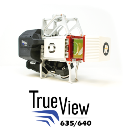
Survey-Grade UAS LIDAR/Imaging Systems with True View® 635/640

GeoCue’s first generation of RIEGL miniVUX-2UAV-based 3DIS integrated systems, the True View 615 and 620, introduced compact, survey-grade 3DIS providing high network accuracy and precision (low noise).  Combined with GeoCue’s industry-leading integrated data processing software suite, True View EVO, all GeoCue 3DIS include the full post-processing software workflow, including direct integration with Applanix POSPac. 

Unlike more common LIDAR/camera UAS software suites that have separate workflows for point classification or point colorization, the integrated EVO workflow generates fully geo-referenced, point-traced, colorized point clouds in less time than it takes to fly the mission.  As an added bonus, True View EVO supports the direct creation of many standard project deliverables including ground classified point clouds, surface models, contours, Digital Elevation Models (DEMs), volumetric analysis, wire extraction and similar products, without the need for additional third-party software.  

Staying in step with RIEGL’s latest products, the True View 635/640 are equipped with the recently released RIEGL miniVUX-3UAV laser scanner.  The miniVUX-3UAV, a 360° rotating mirror scanner, increases the scanner frequency to 300 kHz and offers a unique mode where the 200,000 pulse per second scan rate is focused in a 120° cross-track field of view, providing significantly increased point densities in aerial mapping applications.  This increased density, when fused with GeoCue’s integrated mapping cameras, provides stunning colorized point clouds bringing collected data to life!

GeoCue’s President, Lewis Graham, stated, “RIEGL sets the standard for high accuracy laser scanning. Our R&D team were amazed at the density and quality of the data produced by the miniVUX-3UAV. RIEGL proactively worked with us to slot this model into our long-term supply agreement, allowing us early access to the new system.  In fact, we were able to ship the first production unit to a customer in late January.”

GeoCue is excited to continue its partnership with RIEGL in the development of survey-grade True View 3D Imaging Systems. The True View 635/640 3DIS® are available for shipment now. GeoCue Australia and designated resellers are available to assist and deliver your True View 3DIS® needs. Check out GeoCue’s reseller page to find a True View reseller near you. 

About GeoCue

GeoCue is the largest supplier of kinematic LIDAR processing tools in North America and LP360 is one of the world’s most widely used tools for exploiting point cloud data. In 2014, GeoCue Group started a division focused on using small Unmanned Aerial Systems for high accuracy mapping. Leveraging our expertise in production, risk reduction, and point cloud processing tools, we are continuing to bring new services and products to market to provide surveyors and other geomatics professionals exciting tools for geospatial data extraction using low cost drones including our True View® drone camera and 3DIS® systems product line. To learn more, visit www.geocue.com.

Filed Under: Hardware, LiDAR

About Editor

Glenn is a geographer and a GIS professional with over 20 years experience in the industry. He's the co-founder of GISuser and several other technology web publications.

Top Press

The Global Expansion of Aueshah: A New Era of High Jewelry

April 11, 2026 By GISuser

KARACHI, PAKISTAN. The international luxury market is experiencing a profound shift. Consumers are increasingly rejecting mass-produced goods in favor of rarity, authenticity, and emotional depth. … [Read More...]

State of Data Science Report – AI and Open Source at Work

September 10, 2025 By GISuser

AI and Open Source at Work … [Read More...]

Topcon Announces Landmark Expansion of Topnet Live Network Across USA

January 26, 2025 By GISuser

LIVERMORE, Calif.---Topcon Positioning Systems has announced a significant expansion of its Topnet Live reference station network, introducing 200 new geodetic stations strategically positioned across … [Read More...]

Space Flight Laboratory (SFL) Announces Launch and Deployment of NorSat-4 Maritime Monitoring Microsatellite

January 19, 2025 By GISuser

Seventh Satellite Developed by SFL for Norway … [Read More...]

HERE and BMW Group extend partnership on AI-powered mapping system

January 8, 2025 By GISuser

HERE and BMW Group extend partnership on AI-powered mapping system for automated driving and enhanced road safety … [Read More...]

SFL Missions Inc. Confirms Successful Deployment of Six HawkEye 360 Radio Frequency Detection Satellites with Advanced Capabilities

October 27, 2026 By GISuser

MĀHIA, New Zealand, 26 October 2026 – SFL Missions Inc. today confirmed the successful deployment of six radio frequency (RF) detection and geolocation satellites for HawkEye 360 … [Read More...]

Canadian-Built RoadEng 12 Uses AI to Find the Best Location for New Resource and Rural Roads

October 17, 2026 By GISuser

Vancouver, BC, Canada, October 15, 2026 – North Vancouver-based Softree Technical Systems today released RoadEng Version 12, used in more than 75 countries to locate and design … [Read More...]

Beyond the Map: How AI Image and Video Generation Is Changing Geospatial Communication

October 14, 2026 By GISuser

Ask anyone who has shipped a GIS project what the hardest part was, and the answer is rarely the spatial analysis. It is almost always the communication. A site suitability … [Read More...]

From Maternity to Everyday Wear: Building a Wardrobe That Grows With You

October 14, 2026 By GISuser

When I think about maternity clothing, I feel the biggest mistake is buying too many things at once. During pregnancy, your body keeps changing, and something that fits well today … [Read More...]

eMMC 5.1 Explained: Features, Performance, and Applications in Modern Devices

October 14, 2026 By GISuser

Storage technology is an essential part of modern computing, influencing how devices store information, launch applications, and manage everyday workloads. Although … [Read More...]

Copyright gletham Communications 2015 - 2026

Go to mobile version