

Maxar Technologies collected new satellite imagery over the last two days of the intense wildfires burning across Oregon, focusing in on the aftermath of the Alameda Wildfire (also known as the Glendower Wildfire). On Tuesday morning (September 8, 2020), wildfires tore through the southern Oregon towns of Phoenix and Talent that destroyed hundreds of homes and property near Medford.

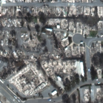
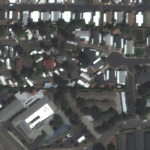
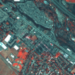

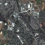


Satellite image ©2020 Maxar Technologies.