GIS user technology news

News, Business, AI, Technology, IOS, Android, Google, Mobile, GIS, Crypto Currency, Economics

  • Advertising & Sponsored Posts
    • Advertising & Sponsored Posts
    • Submit Press
  • PRESS
    • Submit PR
    • Top Press
    • Business
    • Software
    • Hardware
    • UAV News
    • Mobile Technology
  • FEATURES
    • Around the Web
    • Social Media Features
    • EXPERTS & Guests
    • Tips
    • Infographics
  • Blog
  • Events
  • Shop
  • Tradepubs
  • CAREERS
You are here: Home / * PRESS / Hardware / Scan Dimension Releases Mac Version of Popular SOL 3D Scanner

Scan Dimension Releases Mac Version of Popular SOL 3D Scanner

June 25, 2019 By GISuser

Latest Product Reviews Are in: SOL 3D Scanner IS “Love at First Scan”
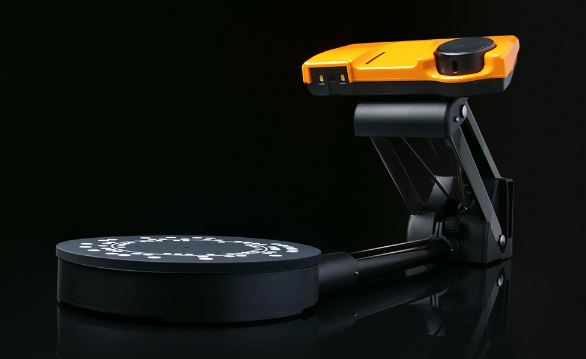
Chantilly, VA — June 25, 2019 — Scan Dimension®, developer of 3D scanning, imaging, and realization technology, today announces the macOS version of its 3D desktop scanner, SOL.
Scan Dimension’s SOL is the market’s most user-friendly 3D scanner, ideal for the engineer, maker, designer, or hobbyist. Now, customers can use SOL with macOS Mojave.

Recently released, the SOL 3D scanner has been receiving praise for its advancements in 3D scanning. Reviewer Jordan Druber of 9to5Toys.com gave it notable marks for its easy setup and high-quality scans. More reviews are on the company’s website at ScanDimension.com.

“The feedback on SOL has been fantastic. Designers, engineers, and other macOS users can now experience SOL’s capabilities,” comments Chip Coons, Product Manager, Scan Dimension. “Our goal is to provide our customers with an easy-to-use 3D scanner with professional accuracy, yet without a premium price — and SOL for Mac and PC delivers just that.”

SOL boasts 0.1mm scan accuracy, outperforming more expensive scanners in the market. SOL eliminates three important hurdles to 3D scanning: complex calibration, time-consuming software manipulation, and manual mesh alignment.

This portable and affordable 3D scanner creates 3D renditions of objects up to 6.69 inches. Customers can save files in standard formats such as OBJ, PLY, STL, DAE, and XYZ.
SOL retails for $599 and includes the hardware, software, tent, cover, cables, cleaning cloth, and a sample object to scan. SOL is available for purchase through ScanDimension.com. Special offers may apply.

About Scan Dimension
Scan Dimension® is a trusted source for 3D scanning, imaging, and realization technology. The company develops and manufactures leading-edge solutions, enabling high-precision 3D capture across a variety of industries including manufacturing, construction, and engineering.

Scan Dimension is owned by Global Scanning A/S. Based in Denmark, Global Scanning has been a market leader in scanning technology for 28 years. For more information visit ScanDimension.com

Filed Under: Hardware

Top Press

The Global Expansion of Aueshah: A New Era of High Jewelry

April 11, 2026 By GISuser

KARACHI, PAKISTAN. The international luxury market is experiencing a profound shift. Consumers are increasingly rejecting mass-produced goods in favor of rarity, authenticity, and emotional depth. … [Read More...]

State of Data Science Report – AI and Open Source at Work

September 10, 2025 By GISuser

AI and Open Source at Work … [Read More...]

Topcon Announces Landmark Expansion of Topnet Live Network Across USA

January 26, 2025 By GISuser

LIVERMORE, Calif.---Topcon Positioning Systems has announced a significant expansion of its Topnet Live reference station network, introducing 200 new geodetic stations strategically positioned across … [Read More...]

Space Flight Laboratory (SFL) Announces Launch and Deployment of NorSat-4 Maritime Monitoring Microsatellite

January 19, 2025 By GISuser

Seventh Satellite Developed by SFL for Norway … [Read More...]

HERE and BMW Group extend partnership on AI-powered mapping system

January 8, 2025 By GISuser

HERE and BMW Group extend partnership on AI-powered mapping system for automated driving and enhanced road safety … [Read More...]

Everest Base Camp Helicopter Tour, Helicopter Return Trek, and Manaslu Circuit Trek: Which Nepal Adventure Is Right for You?

November 6, 2026 By GISuser

Almost everyone planning a Nepal trip runs into the same wall. You want the big mountains, you have a fixed number of days, and every itinerary you read seems to promise something … [Read More...]

SFL Missions Inc. Confirms Successful Deployment of Six HawkEye 360 Radio Frequency Detection Satellites with Advanced Capabilities

October 27, 2026 By GISuser

MĀHIA, New Zealand, 26 October 2026 – SFL Missions Inc. today confirmed the successful deployment of six radio frequency (RF) detection and geolocation satellites for HawkEye 360 … [Read More...]

Canadian-Built RoadEng 12 Uses AI to Find the Best Location for New Resource and Rural Roads

October 17, 2026 By GISuser

Vancouver, BC, Canada, October 15, 2026 – North Vancouver-based Softree Technical Systems today released RoadEng Version 12, used in more than 75 countries to locate and design … [Read More...]

Beyond the Map: How AI Image and Video Generation Is Changing Geospatial Communication

October 14, 2026 By GISuser

Ask anyone who has shipped a GIS project what the hardest part was, and the answer is rarely the spatial analysis. It is almost always the communication. A site suitability … [Read More...]

From Maternity to Everyday Wear: Building a Wardrobe That Grows With You

October 14, 2026 By GISuser

When I think about maternity clothing, I feel the biggest mistake is buying too many things at once. During pregnancy, your body keeps changing, and something that fits well today … [Read More...]

Copyright gletham Communications 2015 - 2026

Go to mobile version