GIS user technology news

News, Business, AI, Technology, IOS, Android, Google, Mobile, GIS, Crypto Currency, Economics

  • Advertising & Sponsored Posts
    • Advertising & Sponsored Posts
    • Submit Press
  • PRESS
    • Submit PR
    • Top Press
    • Business
    • Software
    • Hardware
    • UAV News
    • Mobile Technology
  • FEATURES
    • Around the Web
    • Social Media Features
    • EXPERTS & Guests
    • Tips
    • Infographics
  • Blog
  • Events
  • Shop
  • Tradepubs
  • CAREERS
You are here: Home / * PRESS / Hardware / senseFly Introduces eBee X with MicaSense RedEdge-MX

senseFly Introduces eBee X with MicaSense RedEdge-MX

March 18, 2019 By GISuser

A seamless dual solution for accurate and efficient crop analysis
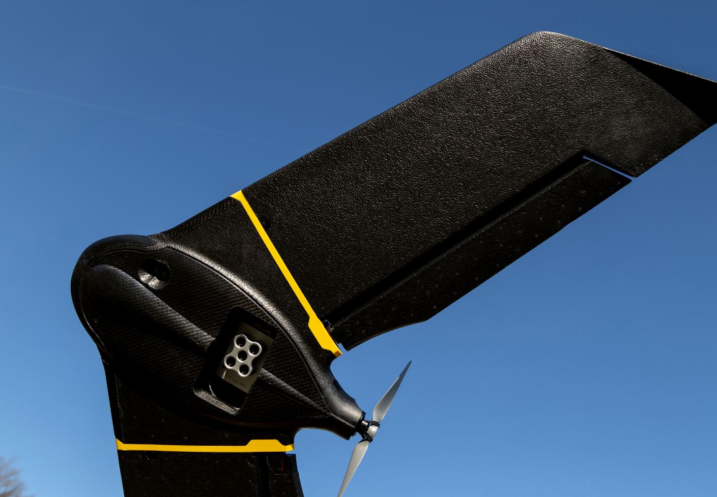
senseFly Introduces eBee X with MicaSense RedEdge-MX

Cheseaux-sur-Lausanne, Switzerland, March 13, 2019 – senseFly, the leading provider of fixed-wing drone solutions, and MicaSense, a leading producer of drone sensors for agriculture, today announce a new dual solution for efficient, in-depth crop analysis—the senseFly eBee X with MicaSense RedEdge-MX.

The sensor that doesn’t compromise meets mapping without limits. New dual solution enables farming, agricultural science, forestry and environmental protection professionals to gain valuable multispectral crop insights more efficiently than with slower, smaller-coverage multirotor drones.

“We know from agricultural customers such as agronomists, crop consultants and researchers that deep, high-resolution crop data is key to effective analysis and decision making,” said Gilles Labossière, CEO of senseFly. “In parallel, when assessing large field areas, or simply looking to map smaller fields or plots quickly, small, slower quadcopter drones often don’t cut it. The eBee X with RedEdge-MX checks both these data and efficiency boxes, making it an ideal crop analysis solution.”

“This seamless, integrated professional drone offering represents an obvious upgrade path for many agricultural professionals. Customers who already use MicaSense’s RedEdge-MX, for example, now have a quicker, more efficient way to analyse the health of their crops, without having to compromise on data quality,” said Eric Waters, General Manager of MicaSense. “At the same time, existing eBee X operators can access the deeper, higher resolution insights that the RedEdge-MX brings.”

The RedEdge-MX is a rugged, built-to-last professional multispectral sensor. Capturing red, green, blue, near-infrared, and red-edge spectral bands, data from this sensor can be used to generate true color composites, basic crop health indexes, and advanced analytical tools like flower identification and weed detection. This, in combination with its durable design, makes RedEdge-MX a multispectral powerhouse.

Key benefits include:

  • The ability to capture plant health images & RGB (composite) images in one flight
  • A fast capture rate, which suits faster fixed-wing flight speeds
  • Global shutter on all five lenses for distortion-free images
  • High-resolution imagery; 8 cm (3.1 in) / pixel GSD at 120 m (400 ft) flight height
  • An aluminium body for better durability and performance in the heat
  • Full access to raw data; generate outputs using a wide variety of processing & analysis platforms
  • Patent pending DLS 2 for highly accurate radiometric calibration

The senseFly eBee X fixed-wing drone is designed to boost the quality, efficiency and safety of commercial UAV operators’ data collection. Its key features include:

  • A unique Endurance Extension option, which unlocks a flight time with RedEdge-MX of up to 75 minutes (versus a maximum endurance of 59 minutes by default) for single-flight coverage of up to 220 ha (540 ac)
  • The ability to work every site, no matter how challenging, thanks to the drone’s built-in Steep Landing technology, ultra-robust design, live air traffic data and more, all backed by senseFly’s professional, localised support
  • A range of professional camera options, including the MicaSense RedEdge-MX, and the new, proprietary senseFly S.O.D.A. 3D, senseFly Aeria X, and senseFly Duet T.

The senseFly eBee X with MicaSense RedEdge-MX (including plug-and-play camera integration kit, Downwelling Light Sensor (DLS2), and Calibrated Reflectance Panel) is available for purchase now via senseFly distribution partners. It is priced at $19,800 USD excluding shipping and importation taxes.

Filed Under: Hardware, UAV/UAS

Top Press

The Global Expansion of Aueshah: A New Era of High Jewelry

April 11, 2026 By GISuser

KARACHI, PAKISTAN. The international luxury market is experiencing a profound shift. Consumers are increasingly rejecting mass-produced goods in favor of rarity, authenticity, and emotional depth. … [Read More...]

State of Data Science Report – AI and Open Source at Work

September 10, 2025 By GISuser

AI and Open Source at Work … [Read More...]

Topcon Announces Landmark Expansion of Topnet Live Network Across USA

January 26, 2025 By GISuser

LIVERMORE, Calif.---Topcon Positioning Systems has announced a significant expansion of its Topnet Live reference station network, introducing 200 new geodetic stations strategically positioned across … [Read More...]

Space Flight Laboratory (SFL) Announces Launch and Deployment of NorSat-4 Maritime Monitoring Microsatellite

January 19, 2025 By GISuser

Seventh Satellite Developed by SFL for Norway … [Read More...]

HERE and BMW Group extend partnership on AI-powered mapping system

January 8, 2025 By GISuser

HERE and BMW Group extend partnership on AI-powered mapping system for automated driving and enhanced road safety … [Read More...]

Everest Base Camp Helicopter Tour, Helicopter Return Trek, and Manaslu Circuit Trek: Which Nepal Adventure Is Right for You?

November 6, 2026 By GISuser

Almost everyone planning a Nepal trip runs into the same wall. You want the big mountains, you have a fixed number of days, and every itinerary you read seems to promise something … [Read More...]

SFL Missions Inc. Confirms Successful Deployment of Six HawkEye 360 Radio Frequency Detection Satellites with Advanced Capabilities

October 27, 2026 By GISuser

MĀHIA, New Zealand, 26 October 2026 – SFL Missions Inc. today confirmed the successful deployment of six radio frequency (RF) detection and geolocation satellites for HawkEye 360 … [Read More...]

Canadian-Built RoadEng 12 Uses AI to Find the Best Location for New Resource and Rural Roads

October 17, 2026 By GISuser

Vancouver, BC, Canada, October 15, 2026 – North Vancouver-based Softree Technical Systems today released RoadEng Version 12, used in more than 75 countries to locate and design … [Read More...]

Beyond the Map: How AI Image and Video Generation Is Changing Geospatial Communication

October 14, 2026 By GISuser

Ask anyone who has shipped a GIS project what the hardest part was, and the answer is rarely the spatial analysis. It is almost always the communication. A site suitability … [Read More...]

From Maternity to Everyday Wear: Building a Wardrobe That Grows With You

October 14, 2026 By GISuser

When I think about maternity clothing, I feel the biggest mistake is buying too many things at once. During pregnancy, your body keeps changing, and something that fits well today … [Read More...]

Copyright gletham Communications 2015 - 2026

Go to mobile version