Field Master Pro™ MS2090A Handheld Spectrum Analyzer Integrated with MA8100A TRX NEON® Signal Mapper
MORGAN HILL, Calif. and GREENBELT, Md., March 5, 2019 — Anritsu Company and TRX Systems introduce the industry’s first field solution that provides 3D indoor and outdoor coverage mapping for 5G New Radio (5G NR) that integrates the Field Master Pro™ MS2090A RF handheld spectrum analyzer with the MA8100A TRX NEON® Signal Mapper. The integrated field test solution allows wireless professionals deploying 5G NR to conduct more accurate measurements than conventional instruments using 2D data to ensure 5G NR networks meet performance specifications both indoors and outside.
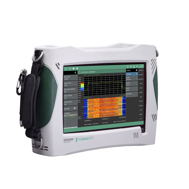
Commercial wireless service providers, public safety entities, and wireless subcontractors can use the Field Master Pro MS2090A with NEON to ensure reliable communications everywhere, from wide open spaces in the countryside to the middle of a large city. NEON can also be used to ensure network performance inside office buildings, on trains in underground tunnels, and in large public spaces such as sports arenas, shopping malls, and airports.
When used outside and in sight of GPS satellites, the solution will use GPS data to continuously track the user while making measurements. Where GPS is not available, the TRX NEON solution using a body-worn tracking unit and Android-based software delivers 3D location and mapping of measurement data inside buildings, underground and in other GPS-denied areas.
In addition to the unique 3D tracking capability, NEON Signal Mapper provides exceptional indoor coverage mapping capabilities. It eliminates the need to manually perform “check-ins” at each test point, provides more data than what can be gathered manually, and removes data recording errors caused by “guesstimating” locations in large buildings. NEON delivers actionable data in areas not easily analyzed such as stairways and elevators, enables quick analysis of signal coverage, and drives faster problem resolution by providing the industry’s only geo-referenced 3D visualization.
The combined solution leverages the industry-leading performance of the Field Master Pro MS2090A, which has the highest continuous frequency coverage up to 54 GHz, real-time spectrum analysis bandwidth up to 100 MHz, and a ruggedized design to withstand the demands of field test. Its best-in-class performance includes Displayed Average Noise Level (DANL) of <-160 dBm, Third Order Intercept (TOI) of typically +20 dBm, and phase noise of typically -110 dBc/Hz @ 100 kHz offset.
5G NR demodulation is supported by the Field Master Pro MS2090A. It provides cell ID, beam ID, RSRP/RSRQ, SINR, and EVM in all 5G bands (sub-6 GHz [3.5 GHz] and millimeter-wave [28 GHz and 39 GHz]). It can also be used to conduct compliance testing, including EIRP, spectral emission mask, and time offset, as well as harmonic and spurious testing. Real-time spectrum analysis spans up to 100 MHz are possible for accurate interference monitoring in the cellular bands or full ISM band.
About TRX Systems
TRX Systems is the developer of the NEON® Location Solution, delivering 3D location and mapping indoors, underground and in dense urban areas where GPS is not available or is unreliable. NEON delivers ubiquitous, low-cost, GPS-denied location through the use of advanced sensor fusion, ranging, and patented dynamic mapping algorithms. NEON patented location technology provides the foundation for a number of commercial applications including NEON Personnel Tracker and NEON Signal Mapper, delivering 3D location indoors, underground, and where GPS may be intentionally denied.
TRX Systems is the recipient of the Silver Edison Award for Innovation in the Navigation and Robotics category, the Tibbetts Award given by the U.S. Small Business Administration for Innovation and Economic Impact of Research and Development, the TEDCO ICE Award for Corporate Excellence and the Innovator Award from the Chesapeake Regional Tech Council (CRTC). TRX’s location software development has been supported by the National Science Foundation, the Defense Advanced Research Projects Agency (DARPA), the U.S. Army, the U.S. Air Force, and the Department of Homeland Security.
To learn more visit www.trxsystems.com or contact TRX at info@trxsystems.com.
About Anritsu
Anritsu Company is the United States subsidiary of Anritsu Corporation, a global provider of innovative communications test and measurement solutions for 120 years. Anritsu’s “2020 VISION” philosophy engages customers as true partners to help develop wireless, optical, microwave/RF, and digital solutions for R&D, manufacturing, installation, and maintenance applications, as well as multidimensional service assurance solutions for network monitoring and optimization. Anritsu also provides precision microwave/RF components, optical devices, and high-speed electrical devices for communication products and systems. The company develops advanced solutions for 5G, M2M, IoT, as well as other emerging and legacy wireline and wireless communication markets. With offices throughout the world, Anritsu has approximately 4,000 employees in over 90 countries.
To learn more visit www.anritsu.com and follow Anritsu on Facebook, LinkedIn, Twitter, and YouTube.
SOURCE Anritsu Company