GIS user technology news

News, Business, AI, Technology, IOS, Android, Google, Mobile, GIS, Crypto Currency, Economics

  • Advertising & Sponsored Posts
    • Advertising & Sponsored Posts
    • Submit Press
  • PRESS
    • Submit PR
    • Top Press
    • Business
    • Software
    • Hardware
    • UAV News
    • Mobile Technology
  • FEATURES
    • Around the Web
    • Social Media Features
    • EXPERTS & Guests
    • Tips
    • Infographics
  • Blog
  • Events
  • Shop
  • Tradepubs
  • CAREERS
You are here: Home / * PRESS / Business / Election Commission of Malaysia Selects SuperSurv for Efficient Spatial Data Collection

Election Commission of Malaysia Selects SuperSurv for Efficient Spatial Data Collection

November 6, 2016 By Editor

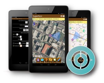
Supergeo is delighted to announce that with the assistance from Supergeo’s partner in Malaysia, Suruhanjaya Pilihan Raya Malaysia (SPR Malaysia, lit. Election Commission of Malaysia) has recently chosen SuperSurv 3.3 as the mobile GIS software to collect spatial data.

Headquartered in Putrajaya, the administrative center of Malaysia, Election Commission of Malaysia is a government agency formed in 1957 under the constitution, and its core duty is to conduct elections for the lower house of parliament and state legislative bodies. Also, it is also responsible for voter registration, electoral roll revision, constituency adjustment, etc.

Since one of the duties from SPR Malaysia is to review and decide the boundaries of election districts, it is necessary to conduct many fieldworks for collecting the latest spatial data. To achieve the goal, it needs multifunctional mobile GIS software that can work efficiently and accurately in the field. Designed by Supergeo Product Team, SuperSurv is an ideal GIS app to meet such need, supporting both Android and iOS platforms. Other than basic functions of mobile GIS, such as spatial data displaying, creating, and editing, SuperSurv for Android supports NTRIP solution, WMS and WMTS formats, and synchronization with SuperGIS Server. Therefore, fieldworkers of SPR can collect high-precision spatial data, verify the data with various online map services, and then share with the colleagues in the office in real-time, managing the spatial data more efficiently and accurately.


To know more features of SuperSurv:
http://www.supergeotek.com/ProductPage_SuperSurv.aspx?Type=Main%20Features

Download the free trial of SuperSurv:
http://www.supergeotek.com/download_6_mobile.aspx
 

Filed Under: Business Tagged With: Spatial Data Collection, SuperGeo

Editor’s Picks

Wider Selection of US Topo Maps From USGS Now Available in Avenza’s PDF Maps App

Leica RCD30: Better Resolution with More Details for 3D City Modeling

Infographic – The History of the iPhone

Global Mapper 17.2 Released with New Map Book Creation Tool and Cutaway Terrain View

See More Editor's Picks...

About Editor

Glenn is a geographer and a GIS professional with over 20 years experience in the industry. He's the co-founder of GISuser and several other technology web publications.

Recent Industry News

Increase Rev vs. Google AdSense: Unlocking 50%–200% Higher Earnings

August 17, 2026 By GISuser

From Simulator to Open Air: A Practical Start to FPV Flying Safely

August 14, 2026 By GISuser

Pop-Up Card Wallets vs Traditional Slim Wallets: Which Is Better?

August 11, 2026 By GISuser

Comment les PME et commerçants du Québec optimisent la livraison du dernier kilomètre pour fidéliser leurs clients

August 8, 2026 By GISuser

Hot News

State of Data Science Report – AI and Open Source at Work

HERE and AWS Collaborate on New HERE AI Mapping Solutions

Virtual Surveyor Adds Productivity Tools to Mid-Level Smart Drone Surveying Software Plan

Categories

Copyright gletham Communications 2015 - 2026

Go to mobile version