GIS user technology news

News, Business, AI, Technology, IOS, Android, Google, Mobile, GIS, Crypto Currency, Economics

  • Advertising & Sponsored Posts
    • Advertising & Sponsored Posts
    • Submit Press
  • PRESS
    • Submit PR
    • Top Press
    • Business
    • Software
    • Hardware
    • UAV News
    • Mobile Technology
  • FEATURES
    • Around the Web
    • Social Media Features
    • EXPERTS & Guests
    • Tips
    • Infographics
  • Blog
  • Events
  • Shop
  • Tradepubs
  • CAREERS
You are here: Home / * PRESS / Business / CloudCities release with web-based 3D data mashup and advanced editing capabilities

CloudCities release with web-based 3D data mashup and advanced editing capabilities

October 19, 2016 By Editor

AN FRANCISCO, October 19, 2016 — SmarterBetterCities today announced its new CloudCities release with web-based 3D data mashup and advanced editing capabilities. The new CloudCities is now available at www.cloudcities.io. screenshot-2016-10-19-at-4-54-10-pm
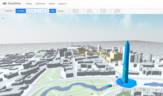
CloudCities is an online platform for visualizing, editing, and publishing interactive 3D city models. It dramatically simplifies creating 3D plans and combining data with it. With the new version, users can now take full control over their 3D content by adding, moving and transforming 3D assets. CloudCities now supports even more available input formats for adding 3D content. Data attributes linked to the 3D objects can be managed directly with the all-new spreadsheet-style attribute editor.

Introducing the CloudCities 3D Editor

The new 3D Editor makes the 3D content creation process a lot easier. Multiple files and 3D assets can be added to the scene directly. The all-new transform tool allows moving, rotating and scaling of the objects in the scene. Objects can be moved between layers by the push of a button. Users now have full control over their 3D scenes.

Spreadsheet-style Attribute Editor

3D data mashup is revolutionized with the new attribute editor. Selected objects in the 3D scene are displayed in a spreadsheet showing all the connected data attributes. Values can be mass-edited as one would be accustomed to in any spreadsheet software. Hit save and all the data is connected to the 3D objects.
CloudCities Asset Manager

Managing your 3D content becomes even easier with the asset manager, giving a complete overview of your 3D assets. Whether they are buildings, cars, street furniture, or any other 3D assets, they are now readily accessible through the asset manager. Assets can be searched, tagged, and previewed.

Additional Format Support: COLLADA, FBX, and OBJ 

CloudCities now supports the de-facto 3D standards of the architecture, engineering, construction, and urban planning industries.

• 3WS: Esri 3D Web Scene
• KMZ: Google Earth
• SKP: SketchUp
• DAE: COLLADA
• FBX: Autodesk FBX
• OBJ: Wavefront Object

The new release will unite the vast user base of the leading geospatial information system (GIS) and building information modeling (BIM) applications from Autodesk, Esri, Trimble, and others.

About CloudCities

CloudCities is the leading platform for publishing interactive 3D city models. It runs in any web browser and on any mobile device, no plugins needed. Share on social media, or embed the 3D viewport directly into your own website. CloudCities enables customers from various industries to publish 3D models and link analytic data.

CloudCities revolutionizes how urban planners and architects can communicate new development projects. Real estate agents use it to visualize developments and connected property details. CloudCities provides lightweight tools for facility and campus management. It transforms the way construction firms visualize building progress and compare planned models to reality data, e.g. from drone scans.

CloudCities is developed by SmarterBetterCities, a fast growing 3D web startup based in Walnut Creek, CA, and Zurich, Switzerland, founded in December 2012.

Filed Under: Business Tagged With: CloudCities, GIS Cloud

About Editor

Glenn is a geographer and a GIS professional with over 20 years experience in the industry. He's the co-founder of GISuser and several other technology web publications.

Top Press

The Global Expansion of Aueshah: A New Era of High Jewelry

April 11, 2026 By GISuser

KARACHI, PAKISTAN. The international luxury market is experiencing a profound shift. Consumers are increasingly rejecting mass-produced goods in favor of rarity, authenticity, and emotional depth. … [Read More...]

State of Data Science Report – AI and Open Source at Work

September 10, 2025 By GISuser

AI and Open Source at Work … [Read More...]

Topcon Announces Landmark Expansion of Topnet Live Network Across USA

January 26, 2025 By GISuser

LIVERMORE, Calif.---Topcon Positioning Systems has announced a significant expansion of its Topnet Live reference station network, introducing 200 new geodetic stations strategically positioned across … [Read More...]

Space Flight Laboratory (SFL) Announces Launch and Deployment of NorSat-4 Maritime Monitoring Microsatellite

January 19, 2025 By GISuser

Seventh Satellite Developed by SFL for Norway … [Read More...]

HERE and BMW Group extend partnership on AI-powered mapping system

January 8, 2025 By GISuser

HERE and BMW Group extend partnership on AI-powered mapping system for automated driving and enhanced road safety … [Read More...]

SFL Missions Inc. Confirms Successful Deployment of Six HawkEye 360 Radio Frequency Detection Satellites with Advanced Capabilities

October 27, 2026 By GISuser

MĀHIA, New Zealand, 26 October 2026 – SFL Missions Inc. today confirmed the successful deployment of six radio frequency (RF) detection and geolocation satellites for HawkEye 360 … [Read More...]

Canadian-Built RoadEng 12 Uses AI to Find the Best Location for New Resource and Rural Roads

October 17, 2026 By GISuser

Vancouver, BC, Canada, October 15, 2026 – North Vancouver-based Softree Technical Systems today released RoadEng Version 12, used in more than 75 countries to locate and design … [Read More...]

Beyond the Map: How AI Image and Video Generation Is Changing Geospatial Communication

October 14, 2026 By GISuser

Ask anyone who has shipped a GIS project what the hardest part was, and the answer is rarely the spatial analysis. It is almost always the communication. A site suitability … [Read More...]

From Maternity to Everyday Wear: Building a Wardrobe That Grows With You

October 14, 2026 By GISuser

When I think about maternity clothing, I feel the biggest mistake is buying too many things at once. During pregnancy, your body keeps changing, and something that fits well today … [Read More...]

eMMC 5.1 Explained: Features, Performance, and Applications in Modern Devices

October 14, 2026 By GISuser

Storage technology is an essential part of modern computing, influencing how devices store information, launch applications, and manage everyday workloads. Although … [Read More...]

Copyright gletham Communications 2015 - 2026

Go to mobile version