GIS user technology news

News, Business, AI, Technology, IOS, Android, Google, Mobile, GIS, Crypto Currency, Economics

  • Advertising & Sponsored Posts
    • Advertising & Sponsored Posts
    • Submit Press
  • PRESS
    • Submit PR
    • Top Press
    • Business
    • Software
    • Hardware
    • UAV News
    • Mobile Technology
  • FEATURES
    • Around the Web
    • Social Media Features
    • EXPERTS & Guests
    • Tips
    • Infographics
  • Blog
  • Events
  • Shop
  • Tradepubs
  • CAREERS
You are here: Home / * PRESS / Business / Analysis of CZMIL and coastal mapping technology at Shallow Survey 2015

Analysis of CZMIL and coastal mapping technology at Shallow Survey 2015

September 14, 2015 By GISuser

September 9, 2015 — Teledyne Optech is pleased to announce that it will attend the Shallow Survey 2015 conference taking place at Plymouth University in England on September 14-18. A current user of the Optech CZMIL Coastal Zone Mapping and Imaging Lidar will make a presentation comparing various lidar bathymeters, and interested attendees can visit Teledyne Optech at booth M14.
2015-09-14 06_38_04-Teledyne Optech Press Release_ Analysis of CZMIL and coastal mapping technology

With the conference focusing on high-resolution surveys in shallow waters, Teledyne Optech expects CZMIL Nova to gain a great deal of attention for its ability to detect objects as small as 1 m3 in water up to 25 meters deep. CZMIL Nova has also expanded the list of coastlines that can be surveyed with lidar, thanks to advanced electronics and data processing techniques that let it survey regions with waters too turbid for other lidars to penetrate. This bathymetric surveying solution is now available even to smaller agencies, which can borrow the system for short surveys through the CZMIL Project Program and install its newly redesigned hardware into small twin-engine aircraft.

Please attend the presentation “A look into the performance of bathymetric lidar systems” given by Chris Macon of the Joint Airborne Lidar Bathymetry Technical Center of Expertise (JALBTCX). JALBTCX and Teledyne Optech have worked together for 25 years to advance bathymetric lidar technology, resulting in CZMIL’s advanced capabilities. JALBTCX spent the summer testing several types of bathymetric lidar sensors, and Mr. Macon will discuss their results at 10:15 on Wednesday the 16th.

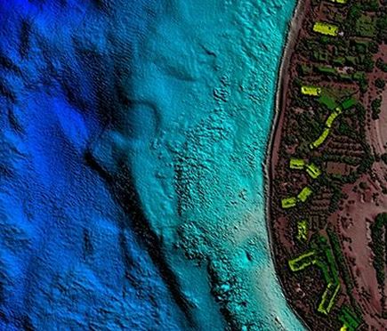
The Teledyne Optech booth will have examples of bathymetry work from CZMIL in turbid water in Asia and Lake Michigan, where HydroFusion’s Turbid Water Module vastly improved bottom detection even in locations with inflowing rivers. In the clearer conditions around Hawaii, JALBTCX performed a production survey of over 1500 km of coastline with CZMIL, ranging from 300 m inland to 1000 m offshore in waters up to 65 m deep. Visitors can learn more about these surveys at the Teledyne Optech booth with technical experts from our bathymetry team, who will discuss how CZMIL’s depth penetration varies with water quality.

The Optech Titan is also an industry focus due to its innovative multispectral lidar technology, which enables shallow-water bathymetry, high-density topography/environmental mapping, and vegetative analyses in a triple-wavelength configuration.

Finally, coastal management authorities can learn about how the Optech ILRIS-MC terrestrial lidar recently helped survey Sydney Harbour in partnership with a multi-beam echosounder. This innovative watercraft-mounted solution is proving a rapid and inexpensive way to survey critical sections of shoreline in extreme detail both above and below the waterline.

Find out more at www.teledyneoptech.com.

About Teledyne Optech

Teledyne Optech is the world leader in high-accuracy lidar 3D survey systems, integrated cameras, and productivity-enhancing workflows. With operations and staff worldwide, Teledyne Optech offers both standalone and fully integrated lidar and camera solutions for airborne mapping, airborne lidar bathymetry, mobile mapping, terrestrial laser scanning, mine cavity monitoring, and industrial process control, as well as space-proven sensors. Teledyne Optech systems are also fully warrantied, with extended warranty packages offered by Teledyne Optech Technical Solutions. Accuracy and productivity matter!

Filed Under: Business Tagged With: Teledyne Optech

Top Press

The Global Expansion of Aueshah: A New Era of High Jewelry

April 11, 2026 By GISuser

KARACHI, PAKISTAN. The international luxury market is experiencing a profound shift. Consumers are increasingly rejecting mass-produced goods in favor of rarity, authenticity, and emotional depth. … [Read More...]

State of Data Science Report – AI and Open Source at Work

September 10, 2025 By GISuser

AI and Open Source at Work … [Read More...]

Topcon Announces Landmark Expansion of Topnet Live Network Across USA

January 26, 2025 By GISuser

LIVERMORE, Calif.---Topcon Positioning Systems has announced a significant expansion of its Topnet Live reference station network, introducing 200 new geodetic stations strategically positioned across … [Read More...]

Space Flight Laboratory (SFL) Announces Launch and Deployment of NorSat-4 Maritime Monitoring Microsatellite

January 19, 2025 By GISuser

Seventh Satellite Developed by SFL for Norway … [Read More...]

HERE and BMW Group extend partnership on AI-powered mapping system

January 8, 2025 By GISuser

HERE and BMW Group extend partnership on AI-powered mapping system for automated driving and enhanced road safety … [Read More...]

Everest Base Camp Helicopter Tour, Helicopter Return Trek, and Manaslu Circuit Trek: Which Nepal Adventure Is Right for You?

November 6, 2026 By GISuser

Almost everyone planning a Nepal trip runs into the same wall. You want the big mountains, you have a fixed number of days, and every itinerary you read seems to promise something … [Read More...]

SFL Missions Inc. Confirms Successful Deployment of Six HawkEye 360 Radio Frequency Detection Satellites with Advanced Capabilities

October 27, 2026 By GISuser

MĀHIA, New Zealand, 26 October 2026 – SFL Missions Inc. today confirmed the successful deployment of six radio frequency (RF) detection and geolocation satellites for HawkEye 360 … [Read More...]

Canadian-Built RoadEng 12 Uses AI to Find the Best Location for New Resource and Rural Roads

October 17, 2026 By GISuser

Vancouver, BC, Canada, October 15, 2026 – North Vancouver-based Softree Technical Systems today released RoadEng Version 12, used in more than 75 countries to locate and design … [Read More...]

Beyond the Map: How AI Image and Video Generation Is Changing Geospatial Communication

October 14, 2026 By GISuser

Ask anyone who has shipped a GIS project what the hardest part was, and the answer is rarely the spatial analysis. It is almost always the communication. A site suitability … [Read More...]

From Maternity to Everyday Wear: Building a Wardrobe That Grows With You

October 14, 2026 By GISuser

When I think about maternity clothing, I feel the biggest mistake is buying too many things at once. During pregnancy, your body keeps changing, and something that fits well today … [Read More...]

Copyright gletham Communications 2015 - 2026

Go to mobile version