Businesses and organizations can use location intelligence to analyze how geography impacts their operations
NEWTON, MA (USA) – Caliper Corporation, the leader in the development of cost-effective professional map software, has announced Maptitude 2014, a major new release of the popular mapping product. Maptitude 2014 provides the most current data as well as significantly enhanced analytical and visualization capabilities, making it the perfect solution for location-based business applications.
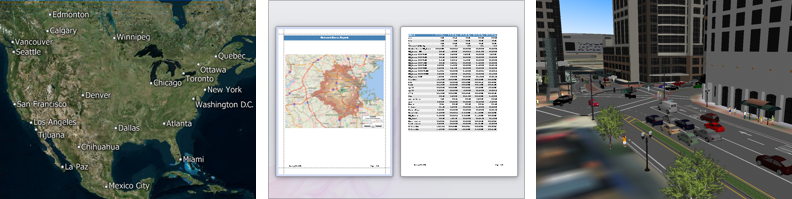
Maptitude, a full-featured but easy-to-use mapping application, is significantly enhanced in this latest version. Create polished reports with a single click, allowing direct sharing of geographic analysis. Seamlessly switch map backgrounds to show aerial photo-imagery or terrain, adding realistic and relatable elements to presentations. Visualize maps in a stunning and compelling 3-D view and add your own 3-D buildings and scenery. The drive-time ring engine is significantly enhanced and provides the most accurate analysis available in any mapping product.
The 2014 USA Country Package included with Maptitude contains new and updated data critical to many industries (more…). Some of the data, such as Caliper’s proprietary purchasing power estimates, are among the most accurate available from any source and significantly more reliable than U.S. Census data. The included data alone are worth many multiples of the software’s purchase price.
"Up-to-date geographic information and the ability to easily share and analyze data are the top priorities for our users, and this release reinforces the ability of Maptitude to meet those needs," said Stewart Berry, Director, Mapping Software, Caliper Corporation.
"Marketing and sales analysts will benefit from knowing the buying power of those ZIP Codes projected to grow over the next 1-5 years, while banks can ensure regulatory compliance using the Federal financial data. Maptitude 2014 allows those in the healthcare industry to map the dynamics of health insurance coverage across regions and between populations. Analysts in these and other industries can also factor in current demographics such as income, population density, age distribution, race, ethnicity, poverty, and more." he added.
Below are the most exciting features of Maptitude 2014, and a complete description of the new features is available here:
- The visualization and sharing capabilities include reports, 3-D views, and choice of map background
- The U.S. Census boundaries and 2014 ZIP Codes contain updated demographics and the latest Census data including disposable income, health insurance coverage, banking compliance data, travel time to work, aggregate/median income by race, and population projections for 2015 and 2020
- The October 2013 maps allow accurate address locating and street visualization plus robust data for calculating distances and travel times, drive-time zones, and drive-time territories
Early feedback from users has been sensational: "Maptitude has been instrumental in our ability to manage, filter, analyze and present data from multiple sources in impactful ways. It is easy to use, yet is ‘feature rich.’ The value of this resource can’t be underestimated in our organization that operates multiple brands in the U.S. and in several international markets. Maptitude can do it all!" said Mike Sawyer, Director of Market Planning, CKE Restaurants Holdings, Inc.
For further information on Maptitude please contact: Media Relations, Caliper Corporation, +1 617 527 4700 +1 617 527 4700 FREE, info@caliper.com.
About Maptitude
With a focus on usability, Maptitude is designed to be a cost-effective and comprehensive mapping software and data product. Maptitude enables organizations to leverage their location-based information to improve decision making and planning, while minimizing expenditure through competitively priced solutions.
Maptitude includes everything required for geographic market analysis, is considered the easiest-to-use professional mapping product, and costs only US$695. Upgrade pricing is available (more…) and for ordering information please visit the Mapping Software Store, e-mail Maptitude Sales, or call U.S. Sales at +1 617-527-4700+1 617-527-4700 FREE. www.MappingSoftware.com
About Caliper
Caliper Corporation develops state-of-the-art Geographic Information Systems (GIS) and transportation software. Caliper is a privately-held corporation and is a leading developer of mapping, redistricting, transportation, traffic simulation, and GIS software. Caliper is also a highly regarded consulting and R&D provider offering professional services in quantitative management consulting, transportation, and decision support systems development. Caliper software products are supported with extensive technical services in GIS applications and training, database development, and software customization.
About CKE Restaurants Holdings, Inc.
CKE Restaurants Holdings, Inc. (CKE) is a privately held company headquartered in Carpinteria, Calif. Through its subsidiaries, CKE owns and licenses Carl’s Jr.® and Hardee’s® quick-service restaurants. CKE operates Carl’s Jr. and Hardee’s as one brand under two names acknowledging the regional heritage of both banners. CKE has a total of 3,449 franchised or company-operated restaurants in 42 states and 30 foreign countries and U.S. territories. Known for its one-of-a-kind premium menu items such as 100 percent Black Angus Six Dollar Thickburgers®, Made from Scratch™ Biscuits, Hand-Breaded Chicken Tenders™ and Fresh Baked Buns, as well as an award-winning marketing approach, the Carl’s Jr./Hardee’s brand continues to deliver substantial and consistent growth in the U.S. and overseas. The Carl’s Jr./Hardee’s system is now 74 percent franchised, with international restaurants representing 17 percent of the system. For more information about CKE, please visit www.ckr.com or its brand sites at www.carlsjr.com and www.hardees.com.