GIS user technology news

News, Business, AI, Technology, IOS, Android, Google, Mobile, GIS, Crypto Currency, Economics

  • Advertising & Sponsored Posts
    • Advertising & Sponsored Posts
    • Submit Press
  • PRESS
    • Submit PR
    • Top Press
    • Business
    • Software
    • Hardware
    • UAV News
    • Mobile Technology
  • FEATURES
    • Around the Web
    • Social Media Features
    • EXPERTS & Guests
    • Tips
    • Infographics
  • Blog
  • Events
  • Shop
  • Tradepubs
  • CAREERS
You are here: Home / News / Geospatial Data / Latest Idaho and New Mexico Quad Topo Maps Available from the USGS

Latest Idaho and New Mexico Quad Topo Maps Available from the USGS

January 25, 2014 By Editor

Newly designed US Topo maps for Idaho and New Mexico, featuring the Public Land Survey System, are now available online for free download

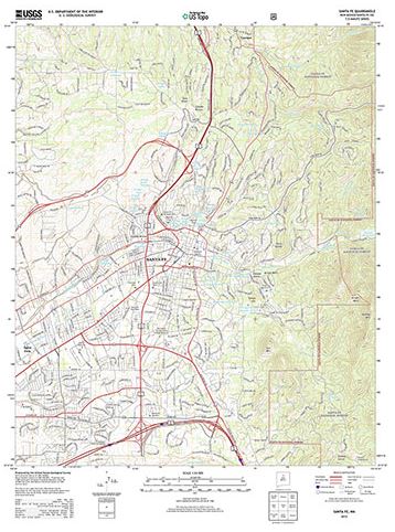
The USGS, in cooperation with other Federal agencies, has posted new Idaho US Topo quadrangles (1,193) and New Mexico quads (1,980 maps) which include Public Land Survey System (PLSS). These are added to the growing list of states west of the Mississippi River to have PLSS data added to US Topo maps.

"It is a privilege to support production of the US Topo maps, as I am an extensive user of these products,” said Kristin Fishburn, a geographer with the USGS. “The capability to turn layers on and off combined with the continuous enhancements in content makes the maps particularly useful for a recreational user. I’m excited to peruse the new Idaho and New Mexico maps."

The PLSS is a way of subdividing and describing land in the United States. All lands in the public domain are subject to subdivision by this rectangular system of surveys, which is regulated by the U.S. Department of the Interior. Other selected states will begin getting PLSS map data during the next respective revision cycle.

The new design for US Topo maps improves readability of maps for online and printed use, while retaining the look and feel of the traditional USGS topo map. Map symbols are easy to read when the digital aerial photograph layer imagery is turned on. 

Other re-design enhancements and new features:

  • New shaded relief layer for enhanced view of the terrain
  • Military installation boundaries, post offices and cemeteries
  • New road classification
  • A slight screening (transparency) has been applied to some features to enhance visibility of multiple competing layers
  • New PDF legend attachment
  • Metadata formatted to support multiple browsers
usgs top quad 

US Topo maps are created from geographic datasets in The National Map, and deliver visible content such as high-resolution aerial photography, which was not available on older paper-based topographic maps. The new US Topo maps provide modern technical advantages that support wider and faster public distribution and on-screen geographic analysis tools for users.

The new digital topographic maps are PDF documents with geospatial extensions (GeoPDF®) image software format and may be viewed using Adobe Reader, available as a no-cost download.

These new quads replace the first edition US Topo maps for Idaho and New Mexico. The replaced maps will be added to the USGS Historical Topographic Map Collection which are also available for free download from The National Map and the USGS Map Locator & Downloader website.

US Topo maps are updated every three years. The initial round of the 48 conterminous state coverage was completed in September of 2012.  Hawaii and Puerto Rico maps have recently been added. More than 400 new US Topo maps for Alaska have been added to the USGS Map Locator & Downloader, but will take several years to complete.

For more information, go to: http://nationalmap.gov/ustopo/


Filed Under: Geospatial Data Tagged With: Geospatial Data, Latest Idaho and New Mexico Quad Topo Maps Available from the USGS, News

About Editor

Glenn is a geographer and a GIS professional with over 20 years experience in the industry. He's the co-founder of GISuser and several other technology web publications.

Top Press

The Global Expansion of Aueshah: A New Era of High Jewelry

April 11, 2026 By GISuser

KARACHI, PAKISTAN. The international luxury market is experiencing a profound shift. Consumers are increasingly rejecting mass-produced goods in favor of rarity, authenticity, and emotional depth. … [Read More...]

State of Data Science Report – AI and Open Source at Work

September 10, 2025 By GISuser

AI and Open Source at Work … [Read More...]

Topcon Announces Landmark Expansion of Topnet Live Network Across USA

January 26, 2025 By GISuser

LIVERMORE, Calif.---Topcon Positioning Systems has announced a significant expansion of its Topnet Live reference station network, introducing 200 new geodetic stations strategically positioned across … [Read More...]

Space Flight Laboratory (SFL) Announces Launch and Deployment of NorSat-4 Maritime Monitoring Microsatellite

January 19, 2025 By GISuser

Seventh Satellite Developed by SFL for Norway … [Read More...]

HERE and BMW Group extend partnership on AI-powered mapping system

January 8, 2025 By GISuser

HERE and BMW Group extend partnership on AI-powered mapping system for automated driving and enhanced road safety … [Read More...]

SFL Missions Inc. Confirms Successful Deployment of Six HawkEye 360 Radio Frequency Detection Satellites with Advanced Capabilities

October 27, 2026 By GISuser

MĀHIA, New Zealand, 26 October 2026 – SFL Missions Inc. today confirmed the successful deployment of six radio frequency (RF) detection and geolocation satellites for HawkEye 360 … [Read More...]

Canadian-Built RoadEng 12 Uses AI to Find the Best Location for New Resource and Rural Roads

October 17, 2026 By GISuser

Vancouver, BC, Canada, October 15, 2026 – North Vancouver-based Softree Technical Systems today released RoadEng Version 12, used in more than 75 countries to locate and design … [Read More...]

Beyond the Map: How AI Image and Video Generation Is Changing Geospatial Communication

October 14, 2026 By GISuser

Ask anyone who has shipped a GIS project what the hardest part was, and the answer is rarely the spatial analysis. It is almost always the communication. A site suitability … [Read More...]

From Maternity to Everyday Wear: Building a Wardrobe That Grows With You

October 14, 2026 By GISuser

When I think about maternity clothing, I feel the biggest mistake is buying too many things at once. During pregnancy, your body keeps changing, and something that fits well today … [Read More...]

eMMC 5.1 Explained: Features, Performance, and Applications in Modern Devices

October 14, 2026 By GISuser

Storage technology is an essential part of modern computing, influencing how devices store information, launch applications, and manage everyday workloads. Although … [Read More...]

Copyright gletham Communications 2015 - 2026

Go to mobile version