GIS user technology news

News, Business, AI, Technology, IOS, Android, Google, Mobile, GIS, Crypto Currency, Economics

  • Advertising & Sponsored Posts
    • Advertising & Sponsored Posts
    • Submit Press
  • PRESS
    • Submit PR
    • Top Press
    • Business
    • Software
    • Hardware
    • UAV News
    • Mobile Technology
  • FEATURES
    • Around the Web
    • Social Media Features
    • EXPERTS & Guests
    • Tips
    • Infographics
  • Blog
  • Events
  • Shop
  • Tradepubs
  • CAREERS
You are here: Home / News / Earth Imagery / DigitalGlo be Announces Top Satellite Images of 2013 Contest

DigitalGlo be Announces Top Satellite Images of 2013 Contest

December 3, 2013 By Editor

Digitalglobe has just launched their annual Top Image of the Year contest, showcasing satellite images of natural disasters, political issues, natural wonders and current events from 2013. DigitalGlobe has compiled the 20 most noteworthy images into a Facebook album and is enlisting its fans to vote for the winner. Voters can “like” as many images as they want, and the top five images with the most “likes” will make it to the final round. 

Later this month, the company will announce the five finalist images in a new Facebook album where voters can “like” to vote for the winning image. For additional votes, voters can also follow DigitalGlobe on Twitter, Google+ and Pinterest to retweet, +1, and repin their favorite images.

You can view DigitalGlobe’s blog post for more information about the contest.

Top entries are:

·         Cambambe Dam, Cuanza River, Angola

·         The Citadel, Aleppo, Syria

·         The Colorado River, Utah

·         Face Art Belfast, Northern Ireland, United Kingdom

·         The Great Barrier Reef, Australia

·         Green Tide, Eastern Coast, Oman

·         Heart Island, Galesnjak, Croatia

·         Giant Rubber Duck, Hong Kong, China

·         Manam Volcano, Madang Province, Papua New Guinea

·         The 2014 Winter Olympics Mountain Venues, Sochi, Russia

·         Mount Vesuvius, Naples, Italy

·         The Namib Desert, Sossusvlei, Namibia

·         Newly Created Island After An Earthquake, Gwadar, Pakistan

·         The Pearl, Doha, Qatar

·         The Schooner Cays, Bahamas

·         The Arlit Uranium Mine, Arlit, Niger

·         The Palau De Les Artes Reina Sofia And Gulliver Park, Valencia, Spain

·         The Palace Of Versailles, Versailles, France

·         Wildfires In Dunalley, Tasmania, Australia
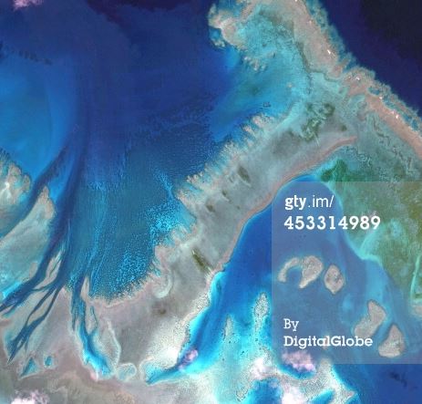
·         Shiyuan Park, Xian, China


Satellite Image of The Great Barrier Reef, Australia (Source)

Filed Under: Earth Imagery Tagged With: DigitalGlo be Announces Top Satellite Images of 2013 Contest, News, R/S & Earth Imaging

About Editor

Glenn is a geographer and a GIS professional with over 20 years experience in the industry. He's the co-founder of GISuser and several other technology web publications.

Top Press

The Global Expansion of Aueshah: A New Era of High Jewelry

April 11, 2026 By GISuser

KARACHI, PAKISTAN. The international luxury market is experiencing a profound shift. Consumers are increasingly rejecting mass-produced goods in favor of rarity, authenticity, and emotional depth. … [Read More...]

State of Data Science Report – AI and Open Source at Work

September 10, 2025 By GISuser

AI and Open Source at Work … [Read More...]

Topcon Announces Landmark Expansion of Topnet Live Network Across USA

January 26, 2025 By GISuser

LIVERMORE, Calif.---Topcon Positioning Systems has announced a significant expansion of its Topnet Live reference station network, introducing 200 new geodetic stations strategically positioned across … [Read More...]

Space Flight Laboratory (SFL) Announces Launch and Deployment of NorSat-4 Maritime Monitoring Microsatellite

January 19, 2025 By GISuser

Seventh Satellite Developed by SFL for Norway … [Read More...]

HERE and BMW Group extend partnership on AI-powered mapping system

January 8, 2025 By GISuser

HERE and BMW Group extend partnership on AI-powered mapping system for automated driving and enhanced road safety … [Read More...]

Everest Base Camp Helicopter Tour, Helicopter Return Trek, and Manaslu Circuit Trek: Which Nepal Adventure Is Right for You?

November 6, 2026 By GISuser

Almost everyone planning a Nepal trip runs into the same wall. You want the big mountains, you have a fixed number of days, and every itinerary you read seems to promise something … [Read More...]

SFL Missions Inc. Confirms Successful Deployment of Six HawkEye 360 Radio Frequency Detection Satellites with Advanced Capabilities

October 27, 2026 By GISuser

MĀHIA, New Zealand, 26 October 2026 – SFL Missions Inc. today confirmed the successful deployment of six radio frequency (RF) detection and geolocation satellites for HawkEye 360 … [Read More...]

Canadian-Built RoadEng 12 Uses AI to Find the Best Location for New Resource and Rural Roads

October 17, 2026 By GISuser

Vancouver, BC, Canada, October 15, 2026 – North Vancouver-based Softree Technical Systems today released RoadEng Version 12, used in more than 75 countries to locate and design … [Read More...]

Beyond the Map: How AI Image and Video Generation Is Changing Geospatial Communication

October 14, 2026 By GISuser

Ask anyone who has shipped a GIS project what the hardest part was, and the answer is rarely the spatial analysis. It is almost always the communication. A site suitability … [Read More...]

From Maternity to Everyday Wear: Building a Wardrobe That Grows With You

October 14, 2026 By GISuser

When I think about maternity clothing, I feel the biggest mistake is buying too many things at once. During pregnancy, your body keeps changing, and something that fits well today … [Read More...]

Copyright gletham Communications 2015 - 2026

Go to mobile version