GIS user technology news

News, Business, AI, Technology, IOS, Android, Google, Mobile, GIS, Crypto Currency, Economics

  • Advertising & Sponsored Posts
    • Advertising & Sponsored Posts
    • Submit Press
  • PRESS
    • Submit PR
    • Top Press
    • Business
    • Software
    • Hardware
    • UAV News
    • Mobile Technology
  • FEATURES
    • Around the Web
    • Social Media Features
    • EXPERTS & Guests
    • Tips
    • Infographics
  • Blog
  • Events
  • Shop
  • Tradepubs
  • CAREERS
You are here: Home / News / Earth Imagery / DigitalGlo be Announces Top Satellite Images of 2013 Contest

DigitalGlo be Announces Top Satellite Images of 2013 Contest

December 3, 2013 By Editor

Digitalglobe has just launched their annual Top Image of the Year contest, showcasing satellite images of natural disasters, political issues, natural wonders and current events from 2013. DigitalGlobe has compiled the 20 most noteworthy images into a Facebook album and is enlisting its fans to vote for the winner. Voters can “like” as many images as they want, and the top five images with the most “likes” will make it to the final round. 

Later this month, the company will announce the five finalist images in a new Facebook album where voters can “like” to vote for the winning image. For additional votes, voters can also follow DigitalGlobe on Twitter, Google+ and Pinterest to retweet, +1, and repin their favorite images.

You can view DigitalGlobe’s blog post for more information about the contest.

Top entries are:

·         Cambambe Dam, Cuanza River, Angola

·         The Citadel, Aleppo, Syria

·         The Colorado River, Utah

·         Face Art Belfast, Northern Ireland, United Kingdom

·         The Great Barrier Reef, Australia

·         Green Tide, Eastern Coast, Oman

·         Heart Island, Galesnjak, Croatia

·         Giant Rubber Duck, Hong Kong, China

·         Manam Volcano, Madang Province, Papua New Guinea

·         The 2014 Winter Olympics Mountain Venues, Sochi, Russia

·         Mount Vesuvius, Naples, Italy

·         The Namib Desert, Sossusvlei, Namibia

·         Newly Created Island After An Earthquake, Gwadar, Pakistan

·         The Pearl, Doha, Qatar

·         The Schooner Cays, Bahamas

·         The Arlit Uranium Mine, Arlit, Niger

·         The Palau De Les Artes Reina Sofia And Gulliver Park, Valencia, Spain

·         The Palace Of Versailles, Versailles, France

·         Wildfires In Dunalley, Tasmania, Australia

·         Shiyuan Park, Xian, China


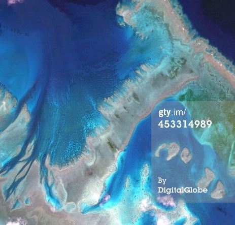
Satellite Image of The Great Barrier Reef, Australia (Source)

Filed Under: Earth Imagery Tagged With: DigitalGlo be Announces Top Satellite Images of 2013 Contest, News, R/S & Earth Imaging

Editor’s Picks

geojobs

GeoJobs.BIZ Employment and Career Resource for GIS, Surveying, and Mapping Professionals

Yellowstone’s Thermal Springs — Their Colors Unveiled

Global Earthquake Numbers on Par for 2015

Data Tip – Customized Coverage from LandScan Global Population Database

See More Editor's Picks...

About Editor

Glenn is a geographer and a GIS professional with over 20 years experience in the industry. He's the co-founder of GISuser and several other technology web publications.

Recent Industry News

The Drift Between Early Notes and Final Case Files in Abuse-Related Legal Support

April 29, 2026 By GISuser

Aerial Surveys Int’l and Global Marketing Insights to Present GEOINT 2026 Workshop on Multi-Domain Geospatial Fusion for Automated Infrastructure Monitoring

April 24, 2026 By GISuser

Why Timing Matters More Than You Think With Spray Seal (And Why People Often Get It Slightly Wrong)

April 22, 2026 By GISuser

The Quiet Planning Stage Most People Don’t See When Building a Pool in Brisbane

April 22, 2026 By GISuser

Hot News

State of Data Science Report – AI and Open Source at Work

HERE and AWS Collaborate on New HERE AI Mapping Solutions

Virtual Surveyor Adds Productivity Tools to Mid-Level Smart Drone Surveying Software Plan

Categories

Copyright gletham Communications 2015 - 2026

Go to mobile version