GISuser.com

GIS and Technology news for mapping professionals

  • PRESS
    • Submit PR
    • Top Press
    • Business
    • Software
    • Hardware
    • UAV News
    • Mobile Technology
  • FEATURES
    • Around the Web
    • Social Media Features
    • EXPERTS & Guests
    • Tips
    • Infographics
  • Events
  • CAREERS
  • Advertise
    • Advertise
  • Blog
  • Shop
  • Tradepubs
You are here: Home / Business / GIS Application Feature – Location Analysis of Funerary Facilities

GIS Application Feature – Location Analysis of Funerary Facilities

November 13, 2013 By Editor

Because of traditional folk custom in Taiwan, more than half of populace thinks funerary facilities as the number one NIMBY facility. The NIMBY effects are reflected the most in facilities including funeral home, crematorium, memorial tower and cemetery. Firstly, these facilities mostly cause uncomfortable feeling; secondly, real estate near these facilities is influenced; lastly, these facilities might destroy environmental landscape, cause air pollution (such as crematorium), and make noise or other pollutions.

 
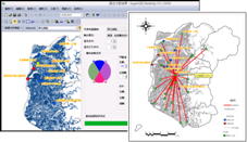
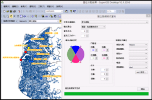
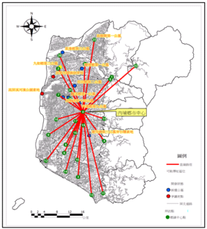
Pingtung City Government, Taiwan tried to negotiate with environmentalists and populace for moving crematorium and funeral home, but there are many ongoing debates that need to be solved still. Therefore, National Pingtung Senior High School planned to find out other proper locations for funerary facilities in a scientific and objective way through utilizing GIS analyses, and provides the relevant branches in government with the analysis result as plan references.
 
Goals

The existing funerary areas have caused problems like stagnant population growth and emigration, lower land price, less land trading, and air quality worsening. Hence, by utilizing GIS, Pingtung Senior High School planned to analyze and find out a better solution of location for crematorium and funeral home based on conceptions including “Feng Shui and Landscape”, “Environment Development and Environmental Protection”, “Development Period”, “Budget” and so forth.

 
Solutions

SuperGIS Desktop 3.1a Professional, SuperGIS Network Analyst and Address Locator are employed in this project. Through the software mentioned above, the relevant feature layers and satellite images of Pingtung county and city are overlapped and being processed with buffer analysis. Meanwhile, Google Earth is adopted to assist in interpreting the relevant topographic features, terrain and land utilization types in the research area. Also, through SuperGIS Network Analyses, the best location of establishing crematorium can be estimated, and what are the differences between ideal location and the proper location can be recognized. At last,“Address Locator” and “Network Analyst” in SuperGIS Desktop 3.1a to analyze the relationship between each land price and the relevant factors.

Containing more plentiful GIS tools, Desktop 3.1a provides GIS users form domains with a professional platform that is used to display, edit, manage, query and analyze spatial data and the related information more effectively and easily.

SuperGIS Network Analyst mainly allows users to perform network analysis for all kinds of applications, such as transportation planning, the shortest path to a scenic spot, pipe and cable installation allocation, convenience store location selection, and home delivery services. Suggestions of the most superior routes or the best locations can be obtained through the network analyst results.

Through overlapping of satellite images and feature layers, users are able to comprehend relative location of funerary greenfield site and adjacent locations.

Address Locator is an extension on SuperGIS Desktop. Through Address Locator, users can enter the required address to have the system conduct data comparison, and the searched address can be marked on the map directly.


Results

In this project, SuperGIS Desktop 3.1a is used to overlay feature layers including Boundary of Villages in South Taiwan, Traffic, Facility, POI Sites of Schools, and Urban Plan and so on. South Taiwan road map is also loaded onto SuperGIS Network Analyst and converted into road weights file for various analyses. True color satellite image with two-meter high resolution is utilized to work with Google Earth to interpret data. Besides, eight public cemeteries and two solid grounds published by Pingtung County Government are adopted as candidate location of funerary facility, and the system will induce the most proper location by buffering and analyzing overlapping layers. Please refer to picture 1 below.

Picture 1: Result of preliminary analysis of buffer and overlapping maps
 
Since the traffic accessibility of each location should be taken into consideration, “Network Analysis” is employed to discuss the distance between the crematorium and each densely inhabited district. This research employs “Location Analysis” in Network Analyst and sets conditions like using hierarchy specified to search provincial routes, arterial roads and straight direction first (please refer to picture 2). In north Pingtung, there are twenty-five towns. This project compared the maximum distance cost from each town to other twenty-four towns, and find out the minimum value from the maximum distance cost. The result found that center area of Neipu town meets our requirements. And the ninth public cemetery of Neipu town is the nearest location among the eleven selected locations to this center area, shown as in the picture 3.
 
Picture 2: Data built by SuperGIS Network Analyst
Picture 3: center point with the best traffic accessibility through Network Analysis

After comparing the six main factors, containing Protection Area of Water Source Field, Schools, Hospitals, Districts with Densely Residence, Watershed Area, Gas Station, Traffic Accessibility of Network Analysis, and considering various factors and prevailing winds, we founded that the best location in the research result is not the same as the one decided by the county government.

Through GIS research, various limiting conditions, traffic accessibility of each countries and prevailing winds in Pingtung are analyzed with buffer and overlapping maps analysis in scientific and objective way. And we founded that the best location of crematorium and funeral home is not the same as the one that government decided. Therefore, the new location could be discussed and evaluated again by government according to this result

Source: Supergeo

Related Articles on GISuser:

  • Names on the Land: The Role of the U.S. Board on Geographic NamesNames on the Land: The Role of the U.S. Board on Geographic Names
  • USGS Turns 135: Continues Mission of Science for America USGS Turns 135: Continues Mission of Science for America
  • Planning in a 3D World in Prince George’s County, MarylandPlanning in a 3D World in Prince George’s County, Maryland
  • Crowd-Sourcing the National Map: Now a National Effort Crowd-Sourcing the National Map: Now a National Effort
  • Cemetery Management Information System Developed with TatukGIS SDKCemetery Management Information System Developed with TatukGIS SDK
  • GIS Applications – Taiwan Transportation Decision Support System (TTDSS) GIS Applications – Taiwan Transportation Decision Support System (TTDSS)

Filed Under: Business Tagged With: Articles, Business, cemetery, GIS Application Feature - Location Analysis of Funerary Facilities


Editor’s Picks

Free Data from USGS Proves Its Worth for Observing Earth

HxGN LIVE 2015 – Great Stories Continue with the Hexagon Geosystems Track

HP Inc. Wraps Up Another Power-packed NAB Show

Esri Indonesia Story Map Explores Missing AirAsia Flight 8501

See More Editor's Picks...

About Editor

Glenn is a geographer and a GIS professional with over 20 years experience in the industry. He's the co-founder of GISuser and several other technology web publications.

Feed

  • RSS


GIS jobs


Recent Features

Digitalization and Simulation at the North Pole

Natural Gas District & GIS-Centric Asset Management

5 Ways Technology Is Affecting The Sharing Economy

Spotlight – Township Canada: Explore Canadian Legal Land Descriptions on a Map

GeoGeeksinCars – The one in “Tippy” the right-hand drive Mitsubishi, at DevSummit

More Posts from this Category

Categories

Recent Posts

  • The ICC Cricket World Cup Betting – Facts and Betting Tips
  • Blog Title: How eGov Platform Automating Citizen Services
  • A treadmill is one of the most popular fitness equipment
  • 3 Things to Help You Become a Software Engineer
  • Esri Announces Winners of the 2022 ArcGIS Online Competition

RSS Career Tips

  • Four Characteristics of the Best Virtual Employees
  • 8 Questions Employers Should Ask About Coronavirus
  • Jobcase Launches Free Unemployment Resource Center for Workers Impacted by COVID-19
  • Must-Have Gadgets and Technology for the Remote Office Worker
  • Must-Have Gadgets and Technology for the Remote Office Worker


shop for geogeek swag

RSS Tech pubs

  • Top Tips and Tricks: Windows 11
  • The 2022 State of the Data Center Report
  • What is Network Security?

RSS Computers

  • The Essentials of Information Security Kit: Includes a Free PC Security Handbook - 2nd Edition eBook
  • The Idiot's Ultimate Guide to Build Your Own PC
  • Windows... On Speed

RSS HR Tips

  • Measuring and Managing Employee Experience
  • At Work: The 2022 Workplace Trends Report
  • The 2022 Guide To Creating A Great Visitor Experience

RSS Gov Tech

  • The Bipartisan Infrastructure Bill: How you can win more bids
  • How Connected Vehicle Data Can Transform Public Sector Decision-Making
  • Getting started with personalization at scale

RSS UAV news

  • Draganfly Deploys Versatile Situational Assessment Drones to Ukraine
  • Ocean Specialists Inc. Launches “USVs as a Service” Business Line
  • UAS Drone Subsidiary, Duke Robotics’, Sniper Drone showcased at a leading International Airshow in the Asia Pacific Region

RSS Geojobs

  • IT Endpoint Lead
Copyright Spatial Media LLC 2003 - 2015