GIS user technology news

News, Business, AI, Technology, IOS, Android, Google, Mobile, GIS, Crypto Currency, Economics

  • Advertising & Sponsored Posts
    • Advertising & Sponsored Posts
    • Submit Press
  • PRESS
    • Submit PR
    • Top Press
    • Business
    • Software
    • Hardware
    • UAV News
    • Mobile Technology
  • FEATURES
    • Around the Web
    • Social Media Features
    • EXPERTS & Guests
    • Tips
    • Infographics
  • Blog
  • Events
  • Shop
  • Tradepubs
  • CAREERS
You are here: Home / News / Public Safety and Emergency Response / Astrium satellite images to help rescue efforts after Typhoon Haiyan

Astrium satellite images to help rescue efforts after Typhoon Haiyan

November 15, 2013 By Editor

Astrium provides satellite images to help rescue efforts following Typhoon Haiyan (Philippines)

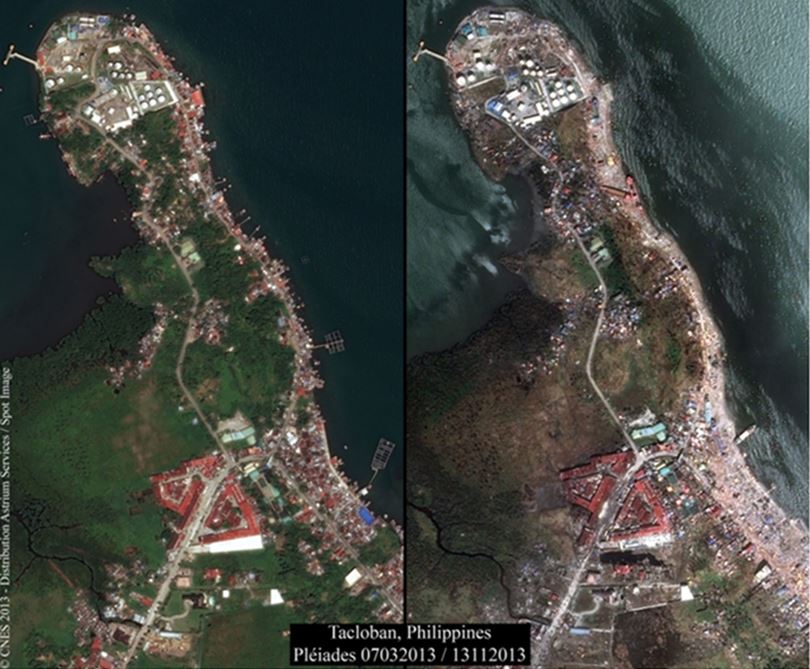
The effects of Typhoon Haiyan, which hit the Philippines on November 8 2013, were photographed on 13 November 2013 by a Pléiades satellite, which had captured images of the same zone (Tacloban) on 7 March 2013.

Astrium builds and operates the Pléiades high-resolution satellites that are providing such images within the framework of the International Charter on Space and Disasters. These images are being made available to rescue teams and authorities.

These high-resolution images can be downloaded here: ftp://ftp.astrium-geo.com/ Philippines/

www.astrium.eads.net


Filed Under: Public Safety and Emergency Response Tagged With: Astrium satellite images to help rescue efforts after Typhoon Haiyan, News, Public Safety and Emergency Response

Editor’s Picks

How Safe is Google Wallet?

How Safe is Google Wallet?

USGS Lidar Base Specification Version 1.2

DigitalGlobe Top Images from 2014 – The fourth annual Top Image contest

Mapping Water Use: Landsat and America’s Water Resources

See More Editor's Picks...

About Editor

Glenn is a geographer and a GIS professional with over 20 years experience in the industry. He's the co-founder of GISuser and several other technology web publications.

Recent Industry News

Top Benefits of AI Video Surveillance for Businesses and Public Spaces

June 5, 2026 By GISuser

How to Choose the Best Office Interior Designers in Delhi for End-to-End Projects

June 3, 2026 By GISuser

Why Bathroom Renovation Services Often Change More Than Just the Bathroom

May 20, 2026 By GISuser

The Drift Between Early Notes and Final Case Files in Abuse-Related Legal Support

April 29, 2026 By GISuser

Hot News

State of Data Science Report – AI and Open Source at Work

HERE and AWS Collaborate on New HERE AI Mapping Solutions

Virtual Surveyor Adds Productivity Tools to Mid-Level Smart Drone Surveying Software Plan

Categories

Copyright gletham Communications 2015 - 2026

Go to mobile version