GIS user technology news

News, Business, AI, Technology, IOS, Android, Google, Mobile, GIS, Crypto Currency, Economics

  • Advertising & Sponsored Posts
    • Advertising & Sponsored Posts
    • Submit Press
  • PRESS
    • Submit PR
    • Top Press
    • Business
    • Software
    • Hardware
    • UAV News
    • Mobile Technology
  • FEATURES
    • Around the Web
    • Social Media Features
    • EXPERTS & Guests
    • Tips
    • Infographics
  • Blog
  • Events
  • Shop
  • Tradepubs
  • CAREERS
You are here: Home / News / GIS, Geo Tech Software / The Newest Version of SuperGIS Desktop 3.1a Now Supports Spanish Interface

The Newest Version of SuperGIS Desktop 3.1a Now Supports Spanish Interface

July 23, 2013 By Editor

Supergeo announced that the newest version of SuperGIS Desktop 3.1a now supports Spanish user interface.

SuperGIS Desktop 3.1a integrating abundant GIS tools offer GIS users from various domains a professional platform for geoprocessing and analyzing, displaying, editing, managing, and querying spatial data even faster and more easily.

SuperGIS Desktop 3.1a not only provides full functions for editing, displaying, querying and analyzing spatial data, but also supports SuperGIS Toolkit to give hundreds of GIS analysis functions and analyst functions. Through Process Designer, users can define geoprocessing functions and workflows to process geo data directly. And the defined process can be published as geoprocessing service with SuperGIS Server 3.1a.

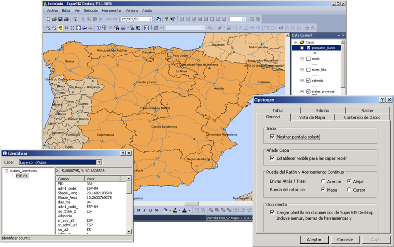
The newest SuperGIS Desktop 3.1a supports Spanish manipulation interface to assist native speakers of Spanish in accomplishing GIS tasks more effectively with the familiar language environment.

To know more details about the product, please download trial from Supergeo website: http://www.supergeotek.com/download_6_desktop.aspx, or contact us with e-mail: staff@supergeotek.com.


Filed Under: GIS, Geo Tech Software Tagged With: Geo Tech Software, GIS, News, The Newest Version of SuperGIS Desktop 3.1a Now Supports Spanish Interface

Editor’s Picks

HP Inc. Combines Power and Style as it Unleashes World’s First Quad Core Workstation Ultrabook

3D Printed Parts for Drones

Salary Guide, Tips for Fastest Growing Industries & Top Technology Positions in Demand

Esri Indonesia Story Map Explores Missing AirAsia Flight 8501

See More Editor's Picks...

About Editor

Glenn is a geographer and a GIS professional with over 20 years experience in the industry. He's the co-founder of GISuser and several other technology web publications.

Recent Industry News

Top Benefits of AI Video Surveillance for Businesses and Public Spaces

June 5, 2026 By GISuser

How to Choose the Best Office Interior Designers in Delhi for End-to-End Projects

June 3, 2026 By GISuser

Why Bathroom Renovation Services Often Change More Than Just the Bathroom

May 20, 2026 By GISuser

The Drift Between Early Notes and Final Case Files in Abuse-Related Legal Support

April 29, 2026 By GISuser

Hot News

State of Data Science Report – AI and Open Source at Work

HERE and AWS Collaborate on New HERE AI Mapping Solutions

Virtual Surveyor Adds Productivity Tools to Mid-Level Smart Drone Surveying Software Plan

Categories

Copyright gletham Communications 2015 - 2026

Go to mobile version