GIS user technology news

News, Business, AI, Technology, IOS, Android, Google, Mobile, GIS, Crypto Currency, Economics

  • Advertising & Sponsored Posts
    • Advertising & Sponsored Posts
    • Submit Press
  • PRESS
    • Submit PR
    • Top Press
    • Business
    • Software
    • Hardware
    • UAV News
    • Mobile Technology
  • FEATURES
    • Around the Web
    • Social Media Features
    • EXPERTS & Guests
    • Tips
    • Infographics
  • Blog
  • Events
  • Shop
  • Tradepubs
  • CAREERS
You are here: Home / News / GIS, Geo Tech Software / Maptitude Country Packages Now Cover 20 Nations

Maptitude Country Packages Now Cover 20 Nations

June 27, 2013 By Editor

NEWTON, MASSACHUSETTS (USA) – There are now 20 Country Packages available for Maptitude 2013. The countries covered include: 3 of the 5 fast-growing BRICS economies: Brazil, South Africa, and India; 6 of the Group of Seven (G7) nations; and 12 of the Group of Twenty major economies.

Caliper is excited to be able to bring the power and flexibility of our Maptitude product suite to a global audience and to enable our customers to make geo-location based decisions internationally. Maptitude ships with one country of your choice (see complete list), and additional Packages can be purchased separately for US$595.

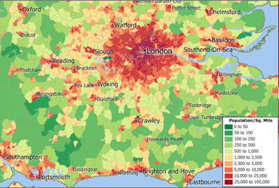
You can now seamlessly switch between the countries you have purchased, which refreshes the Maptitude interface with country-specific tools such as those for creating maps, finding locations, pin mapping (geocoding), and routing.

About Caliper
Caliper Corporation develops state-of-the-art Geographic Information Systems (GIS) software. With a focus on usability, Maptitude is designed to be a cost-effective, professional mapping software product. Maptitude enables organizations to leverage their location-based data to improve decision making and planning, while minimizing expenditure through competitively priced solutions.

Caliper is a privately held corporation and is a leading developer of mapping, redistricting, transportation, and GIS software.


Filed Under: GIS, Geo Tech Software Tagged With: Geo Tech Software, GIS, Maptitude Country Packages Now Cover 20 Nations, News

Editor’s Picks

Botswana Geoscience Portal goes live

Yellowstone’s Thermal Springs — Their Colors Unveiled

Esri Launches New Site to Find Open Data

Trimble Obtains Exemption to Operate its Unmanned Aircraft System

See More Editor's Picks...

About Editor

Glenn is a geographer and a GIS professional with over 20 years experience in the industry. He's the co-founder of GISuser and several other technology web publications.

Recent Industry News

Top Benefits of AI Video Surveillance for Businesses and Public Spaces

June 5, 2026 By GISuser

How to Choose the Best Office Interior Designers in Delhi for End-to-End Projects

June 3, 2026 By GISuser

Why Bathroom Renovation Services Often Change More Than Just the Bathroom

May 20, 2026 By GISuser

The Drift Between Early Notes and Final Case Files in Abuse-Related Legal Support

April 29, 2026 By GISuser

Hot News

State of Data Science Report – AI and Open Source at Work

HERE and AWS Collaborate on New HERE AI Mapping Solutions

Virtual Surveyor Adds Productivity Tools to Mid-Level Smart Drone Surveying Software Plan

Categories

Copyright gletham Communications 2015 - 2026

Go to mobile version