GIS user technology news

News, Business, AI, Technology, IOS, Android, Google, Mobile, GIS, Crypto Currency, Economics

  • Advertising & Sponsored Posts
    • Advertising & Sponsored Posts
    • Submit Press
  • PRESS
    • Submit PR
    • Top Press
    • Business
    • Software
    • Hardware
    • UAV News
    • Mobile Technology
  • FEATURES
    • Around the Web
    • Social Media Features
    • EXPERTS & Guests
    • Tips
    • Infographics
  • Blog
  • Events
  • Shop
  • Tradepubs
  • CAREERS
You are here: Home / News / Earth Imagery / ITT Exelis advanced geo weather instrument passes critical test

ITT Exelis advanced geo weather instrument passes critical test

May 16, 2013 By Editor


ROCHESTER, N.Y.–May. 16, 2013– The ITT Exelis (NYSE: XLS)-developed Advanced Baseline Imager (ABI) has successfully completed thermal vacuum testing. The ABI was exposed to harsh space-like conditions with hundreds of degrees of temperature variation in Rochester, N.Y., marking the second part of its environmental testing regime.
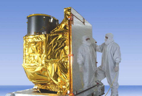
The ITT Exelis-developed Advanced Baseline Imager (ABI) (pictured here) has successfully completed t ...

The ITT Exelis-developed Advanced Baseline Imager (ABI) (pictured here) has successfully completed thermal vacuum testing. The ABI was exposed to harsh space-like conditions with hundreds of degrees of temperature variation in Rochester, N.Y., marking the second part of its environmental testing regime. The ABI is part of the next-generation Geostationary Operational Environmental Satellite-R, or GOES-R, program with NASA and the National Oceanic and Atmospheric Administration. (Photo: ITT Exelis)

"Thermal vacuum testing is a critical step in demonstrating that all design requirements have been met so the ABI can reliably spend years in space sending vital weather data and images back," said Eric Webster, vice president of weather systems at Exelis. "We anticipate an on-time delivery later this year for a 2015 scheduled spacecraft launch."

The first phase of environmental testing for the Exelis imager took place late last year in Fort Wayne, Ind., where it underwent vibration testing, simulating vehicle launch to ensure the ABI can withstand the rigors of its journey into space.

The ABI is part of the next-generation Geostationary Operational Environmental Satellite-R, or GOES-R, program with NASA and the National Oceanic and Atmospheric Administration (NOAA). The satellites are positioned 22,300 miles above Earth providing meteorological and environmental data and images. The program is a follow-on to the current GOES system used by NOAA’s National Weather Service, which provides weather forecasting and imagery for local television reports and researchers, and for which Exelis also provides the imagers.

"The ABI will provide better data to track the development of life-threatening storms earlier," Webster said. "It will make images available to forecasters every 30 seconds rather than every 7.5 minutes today. Also, for the first time, it will allow NOAA to pinpoint and track a specific storm while still collecting data and images from across the country."


Exelis has built every imager and every sounder for NOAA’s GOES satellites since 1994 and was awarded the contract to build the ABI instruments in 2004. Exelis has built more than 60 meteorological payloads for the U.S. government and international customers during the past 40 years. Exelis is on contract to build four ABI instruments for NOAA and NASA, two for Japan and one for South Korea. This long heritage contributed to the U.S. Air Force’s recent decision to award Exelis a contract to develop a final concept for an affordable, low-risk weather imaging sensor.

About ITT Exelis

Exelis is a diversified, top-tier global aerospace, defense, information and technical services company that leverages a 50-year legacy of deep customer knowledge and technical expertise to deliver affordable, mission-critical solutions for global customers. We are a leader in communications, sensing and surveillance, critical networks, electronic warfare, navigation, air traffic solutions and information systems with growing positions in C4ISR, composite aerostructures, logistics and technical services. Headquartered in McLean, Va., the company employs about 19,900 people and generated 2012 sales of $5.5 billion. For more information, visit our website at www.exelisinc.com or connect with us on Facebook, Twitter and YouTube.


Filed Under: Earth Imagery Tagged With: ITT Exelis advanced geo weather instrument passes critical test, News, R/S & Earth Imaging

About Editor

Glenn is a geographer and a GIS professional with over 20 years experience in the industry. He's the co-founder of GISuser and several other technology web publications.

Top Press

The Global Expansion of Aueshah: A New Era of High Jewelry

April 11, 2026 By GISuser

KARACHI, PAKISTAN. The international luxury market is experiencing a profound shift. Consumers are increasingly rejecting mass-produced goods in favor of rarity, authenticity, and emotional depth. … [Read More...]

State of Data Science Report – AI and Open Source at Work

September 10, 2025 By GISuser

AI and Open Source at Work … [Read More...]

Topcon Announces Landmark Expansion of Topnet Live Network Across USA

January 26, 2025 By GISuser

LIVERMORE, Calif.---Topcon Positioning Systems has announced a significant expansion of its Topnet Live reference station network, introducing 200 new geodetic stations strategically positioned across … [Read More...]

Space Flight Laboratory (SFL) Announces Launch and Deployment of NorSat-4 Maritime Monitoring Microsatellite

January 19, 2025 By GISuser

Seventh Satellite Developed by SFL for Norway … [Read More...]

HERE and BMW Group extend partnership on AI-powered mapping system

January 8, 2025 By GISuser

HERE and BMW Group extend partnership on AI-powered mapping system for automated driving and enhanced road safety … [Read More...]

Everest Base Camp Helicopter Tour, Helicopter Return Trek, and Manaslu Circuit Trek: Which Nepal Adventure Is Right for You?

November 6, 2026 By GISuser

Almost everyone planning a Nepal trip runs into the same wall. You want the big mountains, you have a fixed number of days, and every itinerary you read seems to promise something … [Read More...]

SFL Missions Inc. Confirms Successful Deployment of Six HawkEye 360 Radio Frequency Detection Satellites with Advanced Capabilities

October 27, 2026 By GISuser

MĀHIA, New Zealand, 26 October 2026 – SFL Missions Inc. today confirmed the successful deployment of six radio frequency (RF) detection and geolocation satellites for HawkEye 360 … [Read More...]

Canadian-Built RoadEng 12 Uses AI to Find the Best Location for New Resource and Rural Roads

October 17, 2026 By GISuser

Vancouver, BC, Canada, October 15, 2026 – North Vancouver-based Softree Technical Systems today released RoadEng Version 12, used in more than 75 countries to locate and design … [Read More...]

Beyond the Map: How AI Image and Video Generation Is Changing Geospatial Communication

October 14, 2026 By GISuser

Ask anyone who has shipped a GIS project what the hardest part was, and the answer is rarely the spatial analysis. It is almost always the communication. A site suitability … [Read More...]

From Maternity to Everyday Wear: Building a Wardrobe That Grows With You

October 14, 2026 By GISuser

When I think about maternity clothing, I feel the biggest mistake is buying too many things at once. During pregnancy, your body keeps changing, and something that fits well today … [Read More...]

Copyright gletham Communications 2015 - 2026

Go to mobile version