GIS user technology news

News, Business, AI, Technology, IOS, Android, Google, Mobile, GIS, Crypto Currency, Economics

  • Advertising & Sponsored Posts
    • Advertising & Sponsored Posts
    • Submit Press
  • PRESS
    • Submit PR
    • Top Press
    • Business
    • Software
    • Hardware
    • UAV News
    • Mobile Technology
  • FEATURES
    • Around the Web
    • Social Media Features
    • EXPERTS & Guests
    • Tips
    • Infographics
  • Blog
  • Events
  • Shop
  • Tradepubs
  • CAREERS
You are here: Home / Emergency Response / GIS Application Story – Incident Command System of Fire Bureau

GIS Application Story – Incident Command System of Fire Bureau

April 9, 2013 By Editor


Scenario

To improve disaster rescue efficiency of fire brigade and enhance integration of disaster rescue information of districts, Taipei City Fire Department needs a system which can provide commanders and Emergency Dispatch Center with required information and conduct rescue command tasks such as preparation of disaster rescue information, tactics deployment, safety management, etc.

For meeting disaster rescue requirements of diverse map information, the system needs to be capability of integrating and publishing various types of spatial data, and provides front-end applications to assist relevant personnel of Emergency Dispatch Center in viewing, querying map and integrating information of districts. Therefore, commander and staffs are able to query, comprehend disaster information and make decision of disaster rescue instantly.

 
Goals

The system that Taipei City Fire Department needs for providing and integrating disaster rescue information effectively must be capable of integrating Emergency Dispatch Center information management, rescue timing and sequence management, rescue deployment and so forth. Thus, when disastrous damage occurs, rescue commander and staffs can log in this system to recognize the disaster location and distribution of nearby rescue resources to make rescue decision and deploy route of rescue stands.

In addition, the system is required to provide distinct, intelligible and easy-use interface, to integrate diverse spatial data, and to display manipulation functions with icons and drop-down menus. So, users are able to manipulate the system intuitively, recognize disaster location and obtain required information instantly.

Furthermore, to integrate disaster rescue information of districts, the system is required to provide information transmission function; therefore, users can automatically or manually transmit data to the operating system of Emergency Dispatch Center and incident scene.
 
Solutions

Taipei City Fire Department employed SuperObjects, GIS development component product developed by Supergeo, and SuperGIS Server to build Incident Command System, which provides full information integration function, query function, and map display. The functions of the system contain account management, disaster data management, rescue timing management and so on; the system also works with GIS technologies to offer more functions such as basic map viewing, zoom in, zoom out, pan, query, basemap switch, map print, online editing and etc. While disaster occurs, relevant rescue personnel of Fire Bureau can obtain disaster information and recognize disaster location instantly to make disaster rescue decision immediately.

SuperGIS Server is designed for giving the organizations with the abilities to create, manage, integrate and publish the various types of GIS services. Through SuperGIS Server, the spatial data and spatial image in all types as well as GIS functions can be applied as GIS services in desktop, mobile and web applications over the Internet.

SuperObjects, integrating with map and GIS technologies, are COM framework development objects and a core component product of SuperGIS software. It can be embedded directly in programming language of Windows development environment and integrated with other systems. SuperObjects contain hundreds of relevant application objects that can satisfy various development requirements of GIS applications.

 
Results

Incident Command System is composed of service server and front-end applications.

Service Server
SuperGIS Server is adopted as the Service Server to integrate and publish diverse spatial data commonly used for rescuing, including digital map, building and block map, aerial photograph, water resource map and so on. Commonly-used maps can be managed on the server so that users don’t have to save vast geographic data in local computer. To view relevant spatial data, users just need to log in the system, select and load required data, and overlay on the map in local computer. Therefore, rescue personnel in each district are able to achieve rescue tasks through overlaying diverse spatial data and manipulating functions on the system.
 
Front-End Application
Staff of Emergency Dispatch Center can log in the system and employ front-end applications directly. Main features of the front-end application include accessing server services and overlaying with spatial data of local computer to perform analysis and decision making task. Additionally, these applications can be used to view, query and online edit on features and attribute data. The details of application feature are listed below:
 
1. Integration of Disaster Rescue Information
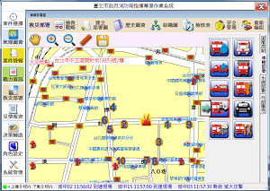
Front-end application enables users to switch theme maps such as digital map, aerial photograph, fire hydrant location map and so forth; users are also allowed to apply on different rescue situations. Through feature filter, map can display the images which match the required condition(s) on one map service and improve display of theme map. Besides, this application can be used to integrate results of rescue route plan and display on map. For example, cars which are on the way to the incident scene can be shown on the display through GPS.
 
2. Drawing Tools
Drawing tools provide users with basic geometry object drawing tool, text marking tool, icon drawing tool, etc in drawing diverse geometries or marking text on the display to assist users in making decision of disaster rescue deployment. In addition, the drawn geometries or text can be sorted, cut, copied or pasted, so users can draw repeatedly or in sequence.
 
3. Layer Management and Editing
Layer management enables users to set the default basemap, select the layer they want to display and modify overlay sequence of layers. And the multiple online editing can set layer editing authority by managing accounts. With online editing, the edited layer can be transmitted to service server after completing editing. Users can employ Undo function if they want to undo the step to repair the mistake during editing.
 
4. Map Navigation
The system integrating various types of spatial data
 
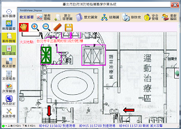
Overlay layers to and display the location incidents happened
 
Local layers overlaied with layers from service server
 
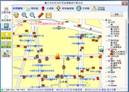
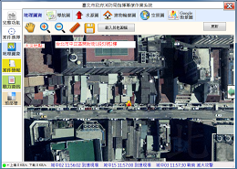
basemap switching

This application provides map navigation functions, including zoom in, zoom out, pan, 1:1 zoom and so on. It enables users to browse required map data quickly.

 
5. Import and Export

Users can save or export the map they viewed as image format anytime, or set print area to print out the map. Moreover, to provide flexible interface design, this application enables users to import picture file in format of JPG, GIF, TIFF and etc and replace icons on the interface

Filed Under: Emergency Response Tagged With: Articles, Emergency Response, GIS Application Story - Incident Command System of Fire Bureau

Editor’s Picks

Unique Hand Drawn Map of London – Ten Years in the Making

Prestigious Award Win For Local Crowd Funded Start Up Business

Arkansas.gov Ranks Among Top 3 Government Websites

CoreLogic Data Reveals Wildfires Pose Big Risk to Nearly 900,000 Western US Homes in 2015

See More Editor's Picks...

About Editor

Glenn is a geographer and a GIS professional with over 20 years experience in the industry. He's the co-founder of GISuser and several other technology web publications.

Recent Industry News

How AI Helps Identify Crystals From Photos

July 10, 2026 By GISuser

The Future of Competitive Gaming: Why DMA Technology is the Ultimate Performance Edge

June 24, 2026 By GISuser

Milwaukee M18FHZ-0 Hackzall Reciprocating Saw – For hardcore cutting in a compact size

June 19, 2026 By GISuser

How Enterprises Are Using AI to Automate 80% of Customer Interactions With Voice Agents

June 16, 2026 By GISuser

Hot News

State of Data Science Report – AI and Open Source at Work

HERE and AWS Collaborate on New HERE AI Mapping Solutions

Virtual Surveyor Adds Productivity Tools to Mid-Level Smart Drone Surveying Software Plan

Categories

Copyright gletham Communications 2015 - 2026

Go to mobile version