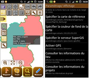
Supergeo announced that SuperSurv 3.1, the mobile GIS application for Android, now supports French interface.
SuperSurv is a mobile GIS application designed for collecting spatial data in the field. Integrating with GIS and GPS technologies, SuperSurv assists field surveyors in collecting spatial data with ease. Besides, through the application which supports global coordinate system settings and common vector layer file in GEO format or SHP format, worldwide users are able to conduct field surveys effectively.
The newest SuperSurv 3.1 adds French interface to provide French users with more friendly manipulation interface. Moreover, to improve edit function and layer management, functions such as feature rotation, snapping, layer transparency settings and so forth are included in SuperSurv 3.1 as well. Therefore, the efficiency of data collection can be greatly improved, and users can have more elastic ways to display layer and view the map.
SuperSurv 3.1 has been officially launched. To know more details of product information and download the trials, please visit Supergeo website:http://www.supergeotek.com/ProductPage_SuperSurv.aspx?Type=Overview , or contact us with e-mail:staff@supergeotek.com.