GISuser.com

Mobile, Technology, and Business news

  • PRESS
    • Submit PR
    • Top Press
    • Business
    • Software
    • Hardware
    • UAV News
    • Mobile Technology
  • FEATURES
    • Around the Web
    • Social Media Features
    • EXPERTS & Guests
    • Tips
    • Infographics
  • Events
  • CAREERS
  • Advertise
    • Advertise
  • Shop
  • Tradepubs
  • facebook
You are here: Home / Software / GIS Application Story – Moalajah e-Map Application

GIS Application Story – Moalajah e-Map Application

March 12, 2013 By Editor

Moalajah is a joint venture between Veolia Water and Besix. As their subsidiary, Moalajah FZC LLC is responsible for operation and maintenance of waste water services and facilitates customer billing and consolidation. The waste water can be used for irrigation, industrial processes, green space and golf course maintenance. Thus Moalajah’s main tasks are to produce resource recovery from wastewater, and make it into important resources.

Moalajah is also advanced on the strategies for biological/chemical treatment which lead to savings in energy and chemical consumptions. Moalajah’s carbon and water footprint initiatives help clients respond to stakeholder expectations to reduce environmental and

resource impacts. Therefore, they need a GIS web-based solution which is able to assist higher management in making decisions and analyzing the area for consideration.

Evolving GeoSystems Technologies, Supergeo platinum reseller in United Arab Emirates, has provided them a complete GIS solution for analysis, searching and reporting based on the plots and related network assets.

 
Solutions

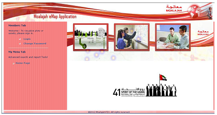
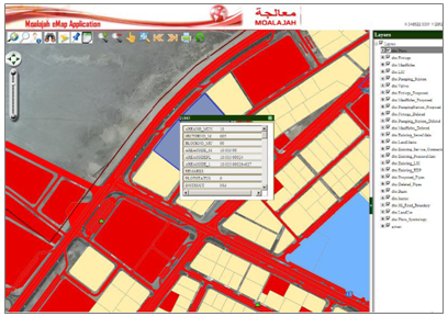
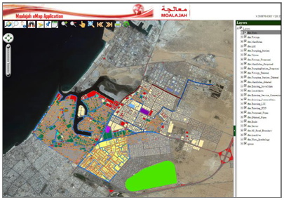
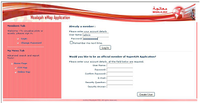
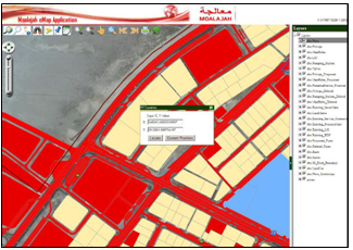
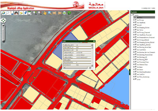
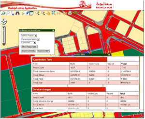
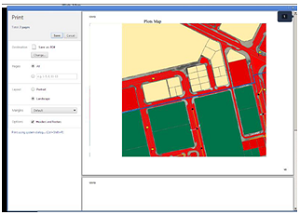
The web application provides interactive visual information of the entire properties and assets located in the Ajman Emirate. The web application is developed using Moalajah existing OGC based geodatabase connected with their Oracle based database and SuperGIS Server.

In the web application, there are various pop-up menus on the searching criteria which help Moalajah operation and management team to analyze the assets and properties in the Ajman Emirates. They can import data from CSV into the application and reports can be exported into PDF and EXCEL. The application is able to perform advance searching based on multiple values. It also has an advance measurement tool with different units of measures.

Hence, Moalajah with the complete GIS solution and modern technologies leverages the value of water and wastewater resources.

The user interface of Moalajah e-Map Application
 
Results

In the web based GIS portal, there are several GIS layers created from their existing databases and overlaid on the high resolution satellite image. These layers are based on the operations of Moalajah and provided for users to have in-depth analysis of their activities. Thus, the website with a number of layers facilitates the higher management to make decision.

The main functions of the website include user management, map manipulation, and data input and output.

The website displays the layer existing in databases and satellite images.
 
User Management
1. User Management
Only the authorized users can access the portal. The user has to register first and login in using his registered username and password. While registering, if a user forgets his/her password, the user can apply the tool to ask for users’ password and it will be sent to his/her email account.
 
2. Members Tab
Once the user logs in, depending on the rights, he/she will be able to access the portal. He/She will have his/her own members tab where all the access links will be displayed.
 
3. Operation and Management/ CS Link
Users can click on the Operation and Management or Customer service link, and users will see a basemap where a widget with all the functions displayed.
 
interface of user managment
 
Map Manipulation
1. Locating
On the main page, users can locate the coordinates of that particular area in consideration.
 
2. Measure Tool
The user can measure a particular plot and have the tool to change the unit of measurement in manipulation.
 
3. Advanced Search Query
In the application, we have a tool to build the advanced queries that use the relational operators to find the particular plots or assets.
 
4. Identify Tool
It helps the user to identify the description of assets and plots.
 
 
Locating Tool


Advanced Search Query 

 Data Input and Output

1. Reports

Users in different departments can have different report types. These reports are mainly classified into the basic and detailed reports.

In the basic reports, we can find the consolidated data of all the plots into consideration and similarly all the asset in consideration whereas in the detailed reports we will get complete information of each plot and asset respectively.

These reports can be exported into PDF and Excel The purpose of these reports is to give an insight and analyze their resources and billing information.

 
2. Print Tool
We can print the map extent with heading and sub headings. We can export the map into PDF as well.
 
Reports Output

Print Tool
 
 
3. Import Tool
We can import the CSV values into the map. We just need to drag and drop on the map and it will be mapped


Related Articles on GISuser:

  • “National Climate Change Viewer” Enables Focus on Future Climate-Driven Changes for U.S. Watersheds “National Climate Change Viewer” Enables Focus on Future Climate-Driven Changes for U.S. Watersheds
  • 10 Cool things About Lizardtech Express Server 9 with ExpressZip 10 Cool things About Lizardtech Express Server 9 with ExpressZip
  • Application Story – e-Map Application for Easy Access to Road Data and ImagesApplication Story – e-Map Application for Easy Access to Road Data and Images
  • GIS Application Story – Agriculture Field Survey SystemGIS Application Story – Agriculture Field Survey System
  • GIS Application Story – Statistical GIS GIS Application Story – Statistical GIS
  • GIS Applications Feature – TGOS CloudGIS Applications Feature – TGOS Cloud

Filed Under: Software Tagged With: Articles, GIS Application Story - Moalajah e-Map Application, software


Editor’s Picks

How Safe is Google Wallet?

How Safe is Google Wallet?

USGS Lidar Base Specification Version 1.2

HERE Beta Will Challenge Your Google Maps Loyalty

Map of the Day – TheCeliacScene, Guides for the Gluten Free

See More Editor's Picks...

About Editor

Glenn is a geographer and a GIS professional with over 20 years experience in the industry. He's the co-founder of GISuser and several other technology web publications.

Feed

  • RSS


GIS jobs


Recent Features

Digitalization and Simulation at the North Pole

Natural Gas District & GIS-Centric Asset Management

5 Ways Technology Is Affecting The Sharing Economy

Spotlight – Township Canada: Explore Canadian Legal Land Descriptions on a Map

GeoGeeksinCars – The one in “Tippy” the right-hand drive Mitsubishi, at DevSummit

More Posts from this Category

Categories

Recent Posts

  • CentralSquare, NextNav Partner to Bring Z-axis Vertical Location to Public Safety Agencies Nationwide
  • Public Safety Agencies Across North America Use APX NEXT Smart Radios for Enhanced Communication, Collaboration and Access to Critical Information
  • OGC elects Dr. Zaffar Sadiq Mohamed-Ghouse to its Board of Directors
  • Autonomous Navigation Market to Generate $15.91 Billion by 2031: Allied Market Research
  • 1Spatial enhances survey capabilities in 1Edit

RSS Career Tips

  • Four Characteristics of the Best Virtual Employees
  • 28 Tools to Conquer the Social Media Recruiting World
  • 8 Questions Employers Should Ask About Coronavirus
  • Jobcase Launches Free Unemployment Resource Center for Workers Impacted by COVID-19
  • Must-Have Gadgets and Technology for the Remote Office Worker


shop for geogeek swag

RSS Tech pubs

  • Explore Fortinet SD-WAN and Get a Free Pair of Apple AirPods, a Sonos Speaker or an Amazon Gift Card
  • LIVE RESEARCH WEBINAR: Building a Foundation for NetSecOps Partnerships with Network Automation
  • The Essentials Of Government Technology - 2022 Kit

RSS Computers

  • HackerProof: Your Guide to PC Security
  • Windows... On Speed
  • The Idiot's Ultimate Guide to Build Your Own PC

RSS HR Tips

  • American Banker: The Employee Experience Is the Customer Experience
  • The problems with automated interviews
  • What to consider when implementing a social media policy

RSS Gov Tech

  • The Essentials Of Government Technology - 2022 Kit
  • Productivity & Profitability: How the Cloud is Revolutionizing the Legal Industry
  • When Do You Really Need the Expense of a Law Firm?

RSS UAV news

  • Dedrone Launches DedronePortable for Military and Commercial Entities Around the World
  • Preliminary Agenda Announced for 2022 UAS Summit & Expo
  • Draganfly Deploys Versatile Situational Assessment Drones to Ukraine

RSS Geojobs

  • IT Endpoint Technician
  • Help Desk Technician
Copyright Spatial Media LLC 2003 - 2015