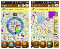
Developed by Supergeo, the mobile survey application, SuperSurv 3.1 is officially launched worldwide.
SuperSurv is a mobile GIS designed for field surveying. Integrating with GIS and GPS technologies, SuperSurv enables filed surveyors to collect spatial data with ease. It supports common vector layer format (GEO and SHP), allowing users to read the cached map (SGT file) in local machine or connect to the services published by SuperGIS Server as base map to enhance field survey efficiency.
The newest SuperSurv 3.1 optimizes editing functions and layer management to provide more user-friendly manipulations. The new functions of editing include feature rotation, snapping and so forth, assisting users in editing feature on mobile devices more effectively and precisely. Besides, for overlaying the layers form diverse resources, SuperSurv supports modification of layer transparency so that users are able to modify layer display settings more elastically to view the spatial data. Furthermore, SuperSurv 3.1 supports digital compass display to assist field surveyors in quickly comprehending the actual direction they are heading.
SuperSurv 3.1 now is officially launched. To know detailed information of the product and download the trial, please visit Supergeo website: http://www.supergeotek.com/ProductPage_SuperSurv.aspx , or contact us with e-mail: staff@supergeotek.com .