GIS user technology news

News, Business, AI, Technology, IOS, Android, Google, Mobile, GIS, Crypto Currency, Economics

  • Advertising & Sponsored Posts
    • Advertising & Sponsored Posts
    • Submit Press
  • PRESS
    • Submit PR
    • Top Press
    • Business
    • Software
    • Hardware
    • UAV News
    • Mobile Technology
  • FEATURES
    • Around the Web
    • Social Media Features
    • EXPERTS & Guests
    • Tips
    • Infographics
  • Blog
  • Events
  • Shop
  • Tradepubs
  • CAREERS
You are here: Home / Emergency Response / GIS Application Feature – Disaster Prevention Area Planning

GIS Application Feature – Disaster Prevention Area Planning

June 13, 2012 By Editor

Scenario

Earthquakes with high magnitude occur often in Taiwan, situated in Circum-Pacific seismic zone. Thus, urban planning system and disaster prevention planning are more important than any other issues in Taiwan. And the distance from residence to the shelters is the main factor to influence plan making of urban disaster prevention. The method to plan shelter range is especially one of the major tasks. This project aims to get buffer results of shelter ranges with diverse considerations via GIS.

Zhubei city, an important city in Taiwan in technology developing, is the research object of urban disaster evacuation area planning. With SuperGIS Desktop 3, researchers not only built the spatial data of urban disaster prevention but also planned and analyzed the temporary shelter range. The analysis results can be the essential information for comparing differences among diverse disaster prevention plans.

 
Goals

In order to tell discrepancies among shelters ranges which are planned with diverse considerations respectively, one location is buffered with various methods to build different shelter ranges. And the buffer results such as diagrams of shelter ranges, population of each blocks and ideal walkable range are compared. Then, via Geographic Information System, these results were overlaid to distinguish different shelter scales, implement concepts of disaster prevention area in urban and construct workable, efficient disaster prevention area system.

Applying parks and schools in Zhubei city as shelter locations, this project buffered and compared different shelter ranges via four methods which include conditions as “buffer with radius value as 600 meters”, “buffer with Facility Location Theory”, “buffer with the actual walkable distance”, or “buffer with the shelter which can be arrived at in five minutes”, and built spatial data through GIS synchronously. Thus, the disaster-prevention plans can be compared and contrasted with each other by overlaying the layers of temporary shelter buffer ranges.

 
Solutions

This project adopted 2 tools to complete indoor processing and field investigation. Field surveyors applied SuperPad 3 to investigate outdoor and record the related spatial and attribute data. In addition, SuperGIS Desktop 3.0 was adopted to operate, analyze and overlay the integrated data processed indoor.

Besides, according to buffer theory and research standard of spatial disaster prevention area, this project utilized spatial analysis to build spatial data through using aerial photographs, map of the city planning and methods of field investigation. Researchers overlaid these spatial data to get information of local disaster prevention and shelter locations that can be references for evaluating shelter ranges.

 
Results
Through analysis and statistic functions in GIS, this project utilized various spatial data processing tools and analyst such as network, buffer and overlaying, and cooperated with estimated value of population in each block to compare values of shelter ranges.
I Building Database for Disaster Prevention Area
This project applied public facilities and schools as shelter locations, and cooperated with field investigation to build attribute data into GIS.
1. Database of Shelter Locations and Networks
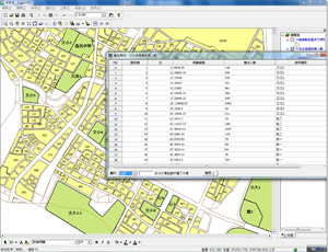
The project filtered some locations and made sure that these locations are proper for shelters, and then conducted the field investigation. Researchers records the related attribute data, including shelters’ names, developing circumstances, area, location of entrances and exits, width, roads around shelters, parking lots, etc. The attribute data are essential for follow-up shelter ranges buffering,
 
2. Buffer Analysis of Disaster Prevention Locations Operation Range
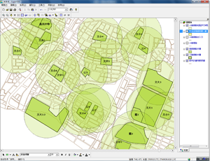
By utilizing GIS buffer analysis, the buffered results of shelter ranges were used to define extents which are divided with the specified interval value, and to implement buffer analysis of population.
 
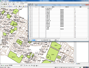
3. Database of Population Research in Each Block in Buffered Zones
According to size and distribution of blocks and regulations of Zhubei city design plan, this project classified building coverage ratio, floor area ratio and land using category of each block to build, save, integrate attribute data. And then, the maximum of population in each block of Zhubei urban planning area were estimated. Users can change visual effects of the estimated results by setting symbol function in SuperGIS Desktop.
Building attribute data of shelter locations and surroundings
 
Buffered results of shelter demarcating
 
II. Overlay Analysis
Overlay analysis is one of the most commonly-used spatial analyses in GIS. Different layers overlaid can be the references for researchers to make decisions. SuperGIS Desktop 3 provides the functions of intersection, union, etc to deal with spatial data and overlay polygons, points or polyline. Thus, the last stage of analysis is to overlay the layers which are built by the attribute database and shelter buffer ranges.
 
The buffer and evaluation system of urban disaster evacuation area, which works with GIS database and the spatial data analysis in SuperGIS Desktop 3, is used to evaluate rationality of buffering urban disaster evacuation locations and shelter ranges. The system can not only provide references in applying GIS to plan urban disaster evacuation locations and buffer ranges but also help researchers to review the distribution of locations according to the development needs of urban plan.


Filed Under: Emergency Response Tagged With: Articles, Emergency Response, GIS Application Feature - Disaster Prevention Area Planning

Editor’s Picks

jack dangermond

First Look – Los Angeles Opens the GeoHub – #OpenData for Citizens and Developers

Vault 7: Security and Location Data

Call For Papers – Location Based Services 2015 Innovate with Location Data

Esri Indonesia Story Map Explores Missing AirAsia Flight 8501

See More Editor's Picks...

About Editor

Glenn is a geographer and a GIS professional with over 20 years experience in the industry. He's the co-founder of GISuser and several other technology web publications.

Recent Industry News

Furnace Repair: Fast Fixes for a Warm, Worry-Free Home

September 15, 2026 By GISuser

Aerial Surveys International Awarded GSA Multiple Award Schedule Contract

September 12, 2026 By GISuser

New Episode Alert: The Colorado State University (CSU) Drone Center

September 10, 2026 By GISuser

Increase Rev vs. Google AdSense: Unlocking 50%–200% Higher Earnings

August 17, 2026 By GISuser

Hot News

State of Data Science Report – AI and Open Source at Work

HERE and AWS Collaborate on New HERE AI Mapping Solutions

Virtual Surveyor Adds Productivity Tools to Mid-Level Smart Drone Surveying Software Plan

Categories

Copyright gletham Communications 2015 - 2026

Go to mobile version