GIS user technology news

News, Business, AI, Technology, IOS, Android, Google, Mobile, GIS, Crypto Currency, Economics

  • Advertising & Sponsored Posts
    • Advertising & Sponsored Posts
    • Submit Press
  • PRESS
    • Submit PR
    • Top Press
    • Business
    • Software
    • Hardware
    • UAV News
    • Mobile Technology
  • FEATURES
    • Around the Web
    • Social Media Features
    • EXPERTS & Guests
    • Tips
    • Infographics
  • Blog
  • Events
  • Shop
  • Tradepubs
  • CAREERS
You are here: Home / Software / Application Feature – Integrated Information of Highway Bus Routes

Application Feature – Integrated Information of Highway Bus Routes

March 14, 2012 By Editor

In recent years, people need traffic information more urgently because of having closer social contact with each other. 

To meet people’s right to know and enable them to query bus information such as routes, stop information and so forth, “Highway Bus Information System” was announced to public in 2009. However, it could neither manage information efficiently with WebGIS surface, nor enable people to query easily due to diverse formats of bus stops. Now, through this project, information of bus routes and stops in Taiwan is investigated and compiled thoroughly to integrate spatial and attribute data which is related to countrywide bus operating routes of the 1,300 roads comprehensively

There will be multiple methods for people to query no matter through the Internet, mobile phones or telephones. It enables users to know the bus information, and provides references for planning itinerary. In addition, transparent information helps to promote will and utilization ratio of bus taking, implement the strategy of improving public transportation and achieve the goal of “Energy Conservation and Carbon Reduction.”

 
Goals
This project aims to establish data of bus routes and stations through the Internet to provide decision strategies to the administrations and multiple query functions to populace by unifying and integrating bus information in Taiwan.
 
Solutions

Environmental Planning
I. GIS Server Software
The system adopts SuperWebGIS as the core GIS platform that can share spatial data online through the map server.

II. Database Management Software
The platform adopts Microsoft SQL Server 2008 as the database management software; the functions of spatial database construct the spatial data and increase efficiency of querying.

Data Integraion
The integrated data include attributes of bus routes , station data, key areas partition, routes, and so forth.

Platform
In addition, platforms for handy website manipulating and functions managing are contained within the Network system. Users are allowed to query bus information such as routes and spatial information of stops on the website. And the administrators are able to manage and differentiate management models of routes and stops on the front-end platform.

 
Results
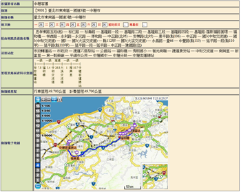
The front-end and back-end platforms include “Route Information Query”, “Route Information Editing”, “Stop Information Query”, “Stop Information Editing”, “Stop Information Statistics”, “Key Area Editing”, “Handy Website.” The details are described as below.

1. Route Information Query  
 

The system allows users to check route attributes including name of transportation practitioners, bus schedule and attribute data of stops along the route or of bus routes displayed on map and stop location. Firstly, query with transportation practitioner, route name or route number. Then, choose information of the route you want to inquire.

 
The results of route information query
 
2. Route Information Editing
  “Route Information Editing” allows administrator to manage and edit data of bus routes. On the electronic map, administrator can edit or digitalize the selected linear segment of bus routes, choose stops along the newly added route segment by cursor, and also edit the attribute data of bus routes and stops simultaneously.

 
Route Editing
 
3. Stop Information Query
  While determining setting-up of related stops, administrator can analyze different decisions through stop information query which contains “Transportation Practitioner Query”, “Stop Name Query” and “Route Number Query.” In “Stop Information Query”, users can query information of single stop, plural stops or a group of stops. Plural stops on the same side and the adjacent location of the road contain stops that are set up by different transportation practitioners. And a group of stops consists of plural stops on both side of the road that represent opposite bus stops. In addition, different map scales also display relationships that correspond to related attributes among each stop.
 
Stop Information Query
 
4. Stop Information Editing
 

When a certain stop is altered, the stop information, such as stop attribute data and coordinates at different scales, can be modified in the system. “Stop Information Compile” enables administrators to set up the stop attributes data and upload related pictures after deriving raw data from scene investigation.

 
5. Stop Information Statistics
  Decision makers might need to query the results of statistics data analyzing of stop numbers or bus schedules in a certain administrative district or in a specified area. “Stop Information Statistics” helps users to analyze information of stops in the selected administrative district or in the specified area drawn by users on the map.
 
 
Stop Information Statistics
   
6. Key Area Information Editing
  Bus stops belong to different administrations in Taiwan. Thus, the establishment of new stops is audited by each administration that is in charge. Each administration can manage the establishment of new stops in the specified area with “Key Area Information Compile.” Each administrator has different authorities to others in compiling key areas information. The main administrators are able to add and compile information by drafting key areas on map and describing the attribute data of these areas.
 
 
Key Area Information Editing
   
7. Handy Website
  To know bus routes, stop locations and related bus information, populace can utilize route query and stop information query on “Handy Website.”


System Benefit
Information of bus routes and stops, through management system in WebGIS, are integrated successfully. In addition, the dependent relations between route and stop are established and used to provide administrations with complete route condition and to check that if the newly added stops correspond to the data or not.

Ideal basic information like attribute data of route and stops efficiently help administrations to manage bus schedules and ticket price, and provide correct information for populace to query especially in the environment of using electronic bus information. Besides, management efficacy can also be improved through utilization of expanding applications in the system while bus information are controlled and audited by administrations.

Filed Under: Software Tagged With: Application Feature - Integrated Information of Highway Bus Routes, Articles, software

Editor’s Picks

Data Tip – The US Interagency Elevation Inventory

Infographic looks at Worlds Best Selling Products: iPad, PS3 and Angry Birds

Opportunity – Promote your Company’s ESRIUC Week Activities with GISuser

NOAA’s Lake Level Viewer of the Great Lakes

See More Editor's Picks...

About Editor

Glenn is a geographer and a GIS professional with over 20 years experience in the industry. He's the co-founder of GISuser and several other technology web publications.

Recent Industry News

The Drift Between Early Notes and Final Case Files in Abuse-Related Legal Support

April 29, 2026 By GISuser

Aerial Surveys Int’l and Global Marketing Insights to Present GEOINT 2026 Workshop on Multi-Domain Geospatial Fusion for Automated Infrastructure Monitoring

April 24, 2026 By GISuser

Why Timing Matters More Than You Think With Spray Seal (And Why People Often Get It Slightly Wrong)

April 22, 2026 By GISuser

The Quiet Planning Stage Most People Don’t See When Building a Pool in Brisbane

April 22, 2026 By GISuser

Hot News

State of Data Science Report – AI and Open Source at Work

HERE and AWS Collaborate on New HERE AI Mapping Solutions

Virtual Surveyor Adds Productivity Tools to Mid-Level Smart Drone Surveying Software Plan

Categories

Copyright gletham Communications 2015 - 2026

Go to mobile version