GIS user technology news

News, Business, AI, Technology, IOS, Android, Google, Mobile, GIS, Crypto Currency, Economics

  • Advertising & Sponsored Posts
    • Advertising & Sponsored Posts
    • Submit Press
  • PRESS
    • Submit PR
    • Top Press
    • Business
    • Software
    • Hardware
    • UAV News
    • Mobile Technology
  • FEATURES
    • Around the Web
    • Social Media Features
    • EXPERTS & Guests
    • Tips
    • Infographics
  • Blog
  • Events
  • Shop
  • Tradepubs
  • CAREERS
You are here: Home / News / GPS / Rugged Tablet PC Tip – The MobileDemand xTablet

Rugged Tablet PC Tip – The MobileDemand xTablet

February 13, 2012 By Editor

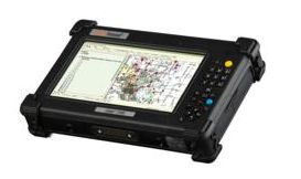
Loads of companies and contractors have a need for a rugged, mobile solution. Here’s one to consider, the MobileDemand xTablet.  Most recently, this device was selected by Elecdata  for use in a mobile GIS app for recording and managing data critical for controlling mosquitoes. About the device – MobileDemand xTablets are built military rugged to withstand the rigors of real-world field applications. They are MIL-STD 810G compliant and have an Ingress (Sealing) Rating of up to IP65, which means they have been tested to survive pressured water, temperature extremes, rain, humidity, salt, sand, dust, shock, vibration and 26 consecutive drops up to 5 feet. xTablets are full Windows 7 PCs, are powered by Intel processors. The tablets are also WLAN and WWAN compatible and provide GPS on some models. Optional cradles, mounts and accessories are also available.

See more details and specs in this announcement – Rugged Tablet PC Provider MobileDemand Announces Partnership with Electronic Data Solutions

Filed Under: GPS, hardware, Mobile, tablet

Editor’s Picks

Learn to Make Decisions Using Lidar Data and Geographic Information Systems

Introducing the new, HP Z Series Workstation Portfolio – Event recap, images, video and key numbers

Aibot X6 uses Leica Nova MultiStation for accurate geospatial data without GNSS

DigitalGlobe Satellite Captures Dramatic Images of Alberta, Canada Oil Sands wildfire #fmmfire

See More Editor's Picks...

About Editor

Glenn is a geographer and a GIS professional with over 20 years experience in the industry. He's the co-founder of GISuser and several other technology web publications.

Recent Industry News

The Drift Between Early Notes and Final Case Files in Abuse-Related Legal Support

April 29, 2026 By GISuser

Aerial Surveys Int’l and Global Marketing Insights to Present GEOINT 2026 Workshop on Multi-Domain Geospatial Fusion for Automated Infrastructure Monitoring

April 24, 2026 By GISuser

Why Timing Matters More Than You Think With Spray Seal (And Why People Often Get It Slightly Wrong)

April 22, 2026 By GISuser

The Quiet Planning Stage Most People Don’t See When Building a Pool in Brisbane

April 22, 2026 By GISuser

Hot News

State of Data Science Report – AI and Open Source at Work

HERE and AWS Collaborate on New HERE AI Mapping Solutions

Virtual Surveyor Adds Productivity Tools to Mid-Level Smart Drone Surveying Software Plan

Categories

Copyright gletham Communications 2015 - 2026

Go to mobile version