GIS user technology news

News, Business, AI, Technology, IOS, Android, Google, Mobile, GIS, Crypto Currency, Economics

  • Advertising & Sponsored Posts
    • Advertising & Sponsored Posts
    • Submit Press
  • PRESS
    • Submit PR
    • Top Press
    • Business
    • Software
    • Hardware
    • UAV News
    • Mobile Technology
  • FEATURES
    • Around the Web
    • Social Media Features
    • EXPERTS & Guests
    • Tips
    • Infographics
  • Blog
  • Events
  • Shop
  • Tradepubs
  • CAREERS
You are here: Home / News / Business / Political, administrative and postcode borders in Africa, 2011

Political, administrative and postcode borders in Africa, 2011

May 27, 2011 By Editor

This month’s map from GfK GeoMarketing provides an overview of the level 1 and 2 political or administrative borders in Africa (data source & map: GfK GeoMarketing).

GfK GeoMarketing has released new postcode and administrative maps for all African countries this May, marking one of the most comprehensive map updates in recent years. In many countries, administrative sub-levels and two-digit postcodes are available for the first time. An even higher level of detail is available for some countries. The new maps reflect the latest boundaries and, in some cases, offer more recent information than officially available in the countries in question.

In the case of administrative boundaries such as states, provinces, districts and municipalities, the largest and second-largest administrative levels have been digitized for almost all countries included in the map edition. Using Senegal as an example, coverage is provided for the "regions" (largest administrative level) and "departements" (second-largest administrative level), which corresponds to 14 and 45 regions, respectively. Coverage of the third largest administrative level is available for South Africa, Morocco, Western Sahara, Congo, Egypt and Tunisia. In the case of Morocco, this equates to 1,509 "communes".

The new Africa Map Edition also provides coverage of at least the two-digit postcode boundaries for all countries that have postal systems. In the case of Kenya, Swaziland, South Africa and several others, even more detailed postcode boundaries are available.
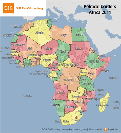
Digital maps of political borders in Africa, 2011 - GfK GeoMarketing


More details on the new digital maps for Africa are provided in the press release published on April 19, 2011: www.gfk-geomarketing.com/fileadmin/newsletter/pressrelease/maps-africa-2011.html

Download the map in high-resolution *.tif format (17 x 15 cm) here (approx. 1.4 MB).

The map may be freely distributed and reproduced if the following attribution is included: “Illustration: GfK GeoMarketing”.


Filed Under: Business Tagged With: 2011, administrative and postcode borders in Africa, Business, News, Political

Editor’s Picks

Feature – Oil and Water: Mapping the South China Sea

A Milestone in the Digital Mapping Industry: Avenza’s PDF Maps App Surpasses One Million Downloads

Esri Launches New Site to Find Open Data

Web GIS Gets A Huge Boost From Esri – What’s New in ArcGIS 10.3

See More Editor's Picks...

About Editor

Glenn is a geographer and a GIS professional with over 20 years experience in the industry. He's the co-founder of GISuser and several other technology web publications.

Recent Industry News

Furnace Repair: Fast Fixes for a Warm, Worry-Free Home

September 15, 2026 By GISuser

Aerial Surveys International Awarded GSA Multiple Award Schedule Contract

September 12, 2026 By GISuser

New Episode Alert: The Colorado State University (CSU) Drone Center

September 10, 2026 By GISuser

Increase Rev vs. Google AdSense: Unlocking 50%–200% Higher Earnings

August 17, 2026 By GISuser

Hot News

State of Data Science Report – AI and Open Source at Work

HERE and AWS Collaborate on New HERE AI Mapping Solutions

Virtual Surveyor Adds Productivity Tools to Mid-Level Smart Drone Surveying Software Plan

Categories

Copyright gletham Communications 2015 - 2026

Go to mobile version