In recent years, because the domestic tourism is growing, the local governments begin to develop some of the river areas to be recreation sites.
However, the man-made development could probably cause the impact on the original environment to result in recreational quality degradation and unrecoverable environmental damage. But if such development is invariably prohibited to protect the completeness of ecological resource because of the reason described above the protection may be against the social and public welfare. Therefore, how to strike a balance between the natural environmental protection and satisfying the public’s need for recreation becomes the challenge the related authorities face.
This project uses an analysis model, integrating the GIS technology and recreation potential analysis, to assist the related authorities in choosing the potential natural and recreation sites.
| Goal | |||||
| The main goal of the project is to help the related authorities to gain the related analysis and integration comparisons of estimated values of creature resources, recreation resources and landscape resources through the establishment of Recreation Potential Analysis Model for Natural Recreation Site. Then, the related authorities can have accurate and rigorous data as references to choose the most suitable recreation site. | |||||
| Solutions | |||||
|
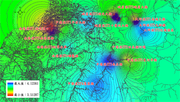
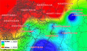
The establishment of Recreation Potential Analysis Model for Natural Recreation Site applies SuperGIS Desktop and Spatial Statistical Analyst, the extension of SuperGIS Desktop, to assist the related staff in doing the statistics and estimation of natural recreational resources, landscape resources and creature resources within the study area. Through the contour maps, the spatial distribution of each estimated value can be expressed. Therefore, the staff can clearly find the spatial range suitable for developed as the recreation area. Results The extent of the project covers the Zhong-gan river mainstream and its three branches, including the Da-ping river, Emei river and Nan-gan river. The staff selects three to five sampling sites at each river area for the recreation potential survey with the Recreation Potential Analysis Model for Natural Recreation Site. During the modeling process, the planners should respectively transform the obtained estimated values into grey relational coefficients of creature data, of recreation potential and of landscape evaluation. The planners can use these data for advanced analysis. In respect of recreation potential, the staff uses the Recreation Potential Analysis Model for Natural Recreation Site to perform spatial interpolation of grey relational coefficient of recreation potential, and maps a contour map of estimated values based on the estimated results. The map tells that the distribution is four peaks and three valleys pattern in the study extent. The highest high is located on the Bei-pu cold spring (peak type) of Da-ping river, and the lowest contour is located on the Nan-gang river bridge (valley type). Therefore, we can explain that the upstream area has higher recreation potential and the lower area near the towns shows lower recreation potential. Overlapping creature resource estimated map and the recreation potential estimated map shows the seven peaks and four valleys pattern. The highest contour is located on the of Nan-zhuang bridge (peak type) and the lowest contour is located on the Nan-gang river mouth (valley type).
At last, overlapping the recreation potential estimated map and the landscape evaluation estimated map shows the four peaks and six valleys pattern. The highest contour is located on the Bei-pu hot spring and Peng-lai bridge of Zhong-gan river (peak type), and the lowest contour is located on the Nan-gan river mouth, Nan-gan river bridge, Ping-an bridge of Zhong-gan river, Shi-liao-keng bridge of Emei river, Emei bridge of Emei river and Hu-grang bridge of Emei river(valley type). After the estimated maps are completed, the planners can find out the proper area for the recreation area plans. The establishment of Recreation Potential Analysis Model for Natural Recreation Site helps the related authorities to calculate the estimated values objectively and precisely; further, the researchers can clearly understand the spatial distribution of each estimated value by mapping. Besides, the results can be used as the important references when the government units are developing the water recreation sites in the future. |