GIS user technology news

News, Business, AI, Technology, IOS, Android, Google, Mobile, GIS, Crypto Currency, Economics

  • Advertising & Sponsored Posts
    • Advertising & Sponsored Posts
    • Submit Press
  • PRESS
    • Submit PR
    • Top Press
    • Business
    • Software
    • Hardware
    • UAV News
    • Mobile Technology
  • FEATURES
    • Around the Web
    • Social Media Features
    • EXPERTS & Guests
    • Tips
    • Infographics
  • Blog
  • Events
  • Shop
  • Tradepubs
  • CAREERS
You are here: Home / News / Google maps, Google earth, Web 2.0 Map Resources / 3D Measuring in Google Earth Pro

3D Measuring in Google Earth Pro

December 7, 2010 By Editor

A fun update from the Google Earth team this week as they provide details of advanced measuring in 3D.  So, why measure in 3D?

 Here’s a sampling of whay you want to do this from Google Lat Long Blog … “3D Measurements can be used by engineers to plan wind farms, real estate firms to determine skyline views for new high rise buildings, construction companies to measure the materials needed for a retrofitting, architects to calculate the space between buildings, and more.”

How it Works – To measure buildings and distances between buildings, just turn on the 3D Buildings layer and click the Ruler Tool icon in the toolbar. If you’re running Google Earth Pro, you’ll notice two new tabs for measuring in 3D: 3D Path and 3D Polygon. Once you do this you can then accomplish the following:

  • Measure the area of the face of a 3D building
  • Measure the height or width of a 3D building
  • Measure the distance between a building and a point on the ground or another building


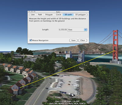
Image Credit (Google)

Advanced Measurement in 3D and more can be accomplished with the new Google earth Pro, also available as a free 7 day download – try it for free for 7 days or buy Google Earth Pro today

Related news… also of interest is the recent release of Google Earth Engine. From Google Labs… 

Google Earth Engine brings together the world’s satellite imagery—trillions of scientific measurements dating back more than 25 years—and makes it available online with tools for scientists, independent researchers, and nations to mine this massive warehouse of data to detect changes, map trends and quantify differences to the earth’s surface.  Using this new tool, we’ve already begun helping scientists develop applications for detecting deforestation and mapping land use trends, and have started working with individual countries to develop their own applications.


Filed Under: Google maps, Google earth, Web 2.0 Map Resources Tagged With: 3D Measuring in Google Earth Pro, Google earth, Google maps, News, Web 2.0 Map Resources

Editor’s Picks

LizardTech White Paper Reveals 12 Hidden Gems in GeoExpress Software

47th Annual Magnet States Report — Where Did America Move in 2014?

International Conference on Unmanned Aerial Vehicles in Geomatics

Prestigious Award Win For Local Crowd Funded Start Up Business

See More Editor's Picks...

About Editor

Glenn is a geographer and a GIS professional with over 20 years experience in the industry. He's the co-founder of GISuser and several other technology web publications.

Recent Industry News

The Future of Competitive Gaming: Why DMA Technology is the Ultimate Performance Edge

June 24, 2026 By GISuser

Milwaukee M18FHZ-0 Hackzall Reciprocating Saw – For hardcore cutting in a compact size

June 19, 2026 By GISuser

How Enterprises Are Using AI to Automate 80% of Customer Interactions With Voice Agents

June 16, 2026 By GISuser

Why On Cloud Shoes Are Worth the Price in Mexico

June 16, 2026 By GISuser

Hot News

State of Data Science Report – AI and Open Source at Work

HERE and AWS Collaborate on New HERE AI Mapping Solutions

Virtual Surveyor Adds Productivity Tools to Mid-Level Smart Drone Surveying Software Plan

Categories

Copyright gletham Communications 2015 - 2026

Go to mobile version