GIS user technology news

News, Business, AI, Technology, IOS, Android, Google, Mobile, GIS, Crypto Currency, Economics

  • Advertising & Sponsored Posts
    • Advertising & Sponsored Posts
    • Submit Press
  • PRESS
    • Submit PR
    • Top Press
    • Business
    • Software
    • Hardware
    • UAV News
    • Mobile Technology
  • FEATURES
    • Around the Web
    • Social Media Features
    • EXPERTS & Guests
    • Tips
    • Infographics
  • Blog
  • Events
  • Shop
  • Tradepubs
  • CAREERS
You are here: Home / News / International ESRI User Conference / 2010 #ESRIUC Exhibitor Spotlight – Javad GNSS

2010 #ESRIUC Exhibitor Spotlight – Javad GNSS

June 18, 2010 By Editor

Visitors to Booth 1901 on the exhibition hall floor of the 2010 International ESRI User Conference will be greeted by the team from JAVAD (once again a Platinum Sponsor of the ESRI UC)

On June 29, Javad GNSS introduced the World to their 3 revolutionary new products… Watch JAVAD GNSS CEO Javad Ashjaee introduce these products on…  See Video HERE

JAVAD GNSS has the longest history and the most experience in design and manufacturing of the state-of-the-art GNSS receivers for survey, GIS, and other high precision applications. The team is the first who combined GPS and GLONASS and currently is the only manufacturer who truly adds Galileo option in mass production.

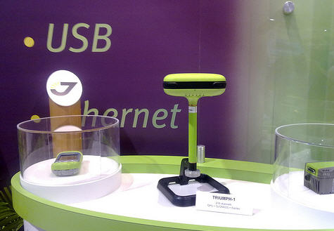
JAVAD GNSS raised the GNSS technology level by introducing the 216-channel TRIUMPH receivers – more than double and far more advanced than any other. TRIUMPH receivers are the seventh generation of GNSS receivers that JAVAD GNSS team has designed in the past 25 years. In this conference JGNSS is going to introduce three new revolutionary products.

Something of particular interest to the GISuser and GIS Professional is Javad’s GISmore – GISmore receiver is based on our TRIUMPH Technology implemented in our TRIUMPH Chip. For the first time in the GNSS history we offer very powerful GIS field mapping receiver with up to 100 Hz RTK, 216 channels of single frequency GPS, Gallileo and GLONASS in a small attractive, sturdy, and watertight box.

See more HERE

Javad GISmore

Features include:

  • Protective Guard Bumper
  • Bluetooth/GSM Antenna
  • GNSS Receiver, Power Board with GSM/Bluetooth and on-board Memory
  • Rechargeable li-Ion Battery
  • Internal GNSS Antenna Connectors
  • Much more!

About the company…

In 1983 I co-pioneered high precision GPS at Trimble, introducing the four-channel Trimble 4000-S geodetic receiver. I single-handedly wrote its complete software. It was the first commercial GPS geodetic receiver and it changed the geodetic survey industry.


I founded Ashtech and in 1989 we introduced the first All-in-One, All-in-View 12-channel Ashtech L-12 GPS receiver, followed by Ashtech Z-12. These were the first truly portable geodetic receivers. We were also the first to integrate GPS and GLONASS satellites.


In 1998 I founded Javad Positioning Systems and introduced Legacy, Odyssey, and Regency GNSS geodetic products, followed by the 76-channel Prego and HiPer receivers. Other companies later copied HiPer. Today many GNSS receivers look like it.


In 2007 I founded JAVAD GNSS and introduced the 216-channel TRIUMPH product and its OEM versions ALPHA, DELTA and SIGMA. We are again the first to commercially offer receivers which track current and future Galileo Satellites.


At the 2010 ESRI User Conference, we will introduce three new revolutionary products.
Visit with us to witness history in the making (again)! Booth 1901 or www.javad.com

Related Articles and Weblinks:

  • JAVAD GNSS ArcPad Extension for ArcServer
  • WOW Technologies On the Floor of the ESRI User Conference (ESRIUC)
  • JAVAD GNSS Offers Unprecedented Stimulus Package  
  • GPS SVN49 – JAVAD GNSS Triumph Receiver Used in Experiment by German Aerospace Center (DLR)  
  • GPS SVN 49 and JAVAD GNSS Triumph Technologies
  • Amerisurv Javad Sponsorship Home Page 
  • www.javad.com

javad

Photo captured at Javad Booth display at 2009 ESRI User Conference

Filed Under: International ESRI User Conference Tagged With: 2010 #ESRIUC Exhibitor Spotlight - Javad GNSS

About Editor

Glenn is a geographer and a GIS professional with over 20 years experience in the industry. He's the co-founder of GISuser and several other technology web publications.

Top Press

The Global Expansion of Aueshah: A New Era of High Jewelry

April 11, 2026 By GISuser

KARACHI, PAKISTAN. The international luxury market is experiencing a profound shift. Consumers are increasingly rejecting mass-produced goods in favor of rarity, authenticity, and emotional depth. … [Read More...]

State of Data Science Report – AI and Open Source at Work

September 10, 2025 By GISuser

AI and Open Source at Work … [Read More...]

Topcon Announces Landmark Expansion of Topnet Live Network Across USA

January 26, 2025 By GISuser

LIVERMORE, Calif.---Topcon Positioning Systems has announced a significant expansion of its Topnet Live reference station network, introducing 200 new geodetic stations strategically positioned across … [Read More...]

Space Flight Laboratory (SFL) Announces Launch and Deployment of NorSat-4 Maritime Monitoring Microsatellite

January 19, 2025 By GISuser

Seventh Satellite Developed by SFL for Norway … [Read More...]

HERE and BMW Group extend partnership on AI-powered mapping system

January 8, 2025 By GISuser

HERE and BMW Group extend partnership on AI-powered mapping system for automated driving and enhanced road safety … [Read More...]

Everest Base Camp Helicopter Tour, Helicopter Return Trek, and Manaslu Circuit Trek: Which Nepal Adventure Is Right for You?

November 6, 2026 By GISuser

Almost everyone planning a Nepal trip runs into the same wall. You want the big mountains, you have a fixed number of days, and every itinerary you read seems to promise something … [Read More...]

SFL Missions Inc. Confirms Successful Deployment of Six HawkEye 360 Radio Frequency Detection Satellites with Advanced Capabilities

October 27, 2026 By GISuser

MĀHIA, New Zealand, 26 October 2026 – SFL Missions Inc. today confirmed the successful deployment of six radio frequency (RF) detection and geolocation satellites for HawkEye 360 … [Read More...]

Canadian-Built RoadEng 12 Uses AI to Find the Best Location for New Resource and Rural Roads

October 17, 2026 By GISuser

Vancouver, BC, Canada, October 15, 2026 – North Vancouver-based Softree Technical Systems today released RoadEng Version 12, used in more than 75 countries to locate and design … [Read More...]

Beyond the Map: How AI Image and Video Generation Is Changing Geospatial Communication

October 14, 2026 By GISuser

Ask anyone who has shipped a GIS project what the hardest part was, and the answer is rarely the spatial analysis. It is almost always the communication. A site suitability … [Read More...]

From Maternity to Everyday Wear: Building a Wardrobe That Grows With You

October 14, 2026 By GISuser

When I think about maternity clothing, I feel the biggest mistake is buying too many things at once. During pregnancy, your body keeps changing, and something that fits well today … [Read More...]

Copyright gletham Communications 2015 - 2026

Go to mobile version