GIS user technology news

News, Business, AI, Technology, IOS, Android, Google, Mobile, GIS, Crypto Currency, Economics

  • Advertising & Sponsored Posts
    • Advertising & Sponsored Posts
    • Submit Press
  • PRESS
    • Submit PR
    • Top Press
    • Business
    • Software
    • Hardware
    • UAV News
    • Mobile Technology
  • FEATURES
    • Around the Web
    • Social Media Features
    • EXPERTS & Guests
    • Tips
    • Infographics
  • Blog
  • Events
  • Shop
  • Tradepubs
  • CAREERS
You are here: Home / News / Earth Imagery / GEOspatial Professional Solutions Inc. Purchases UltraCamL

GEOspatial Professional Solutions Inc. Purchases UltraCamL

May 6, 2010 By Editor

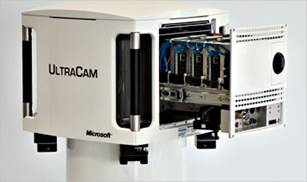
Graz, Austria — May 6, 2010 — GEOspatial Professional Solutions Inc. (GPSi) has contracted with Vexcel Imaging GmbH, a Microsoft® company, to purchase an UltraCamL medium format camera system. 


“Market trends dictated that we transition to a full digital workflow. Despite a struggling economy, we made a business decision to invest in high technology assets that will help us deliver the customer satisfaction we guarantee,” said Ms. Alice C. Ramos, President and Chief Executive Officer of GPSi. “The customer support provided by Vexcel Imaging was a factor in our selection of the UltraCamL, as well as its price and the match between its capabilities and the needs of our customers. The fact that GPSi has been posting positive growth since its inception gave us confidence this is the right decision."

Mr. Paul Hamilton-Rivers, Chief Operating Officer of GPSi, added, “The UltraCamL is the best fit for our requirements. We do small and medium size mapping projects and corridor mapping, and our customers demand quick turnaround and exceptional image quality. The UltraCamL provides the capabilities we need.” He also stated, “We are proud to be the only mapping company based in California offering the UltraCamL aerial digital camera from Vexcel Imaging.”

The UltraCamL photogrammetric medium format digital aerial camera provides a reliable and economical solution for producing image data of exceptional quality. Taking advantage of the large-format camera concept that has proven successful with the UltraCamX, UltraCamXp and UltraCamXp Wide Angle, the UltraCamL offers similar geometric accuracy and dynamic range in the medium format market.

“We are glad to welcome GPSi to the Vexcel Imaging family, and to know that our customer support and price contributed to GPSi’s decision to purchase,” said Alexander Wiechert, Business Director of Microsoft and Managing Director for Vexcel Imaging GmbH. “We designed the UltraCamL to bring the high quality of the UltraCam family to the medium format market and provide a versatile and cost-effective solution to companies.”

About the UltraCamL
The UltraCamL is the largest medium format camera system on the market today suitable for smaller aircraft and projects requiring a rapid response. The system is ideal for smaller large-scale and photogrammetric projects, high-resolution (true) orthophoto production, DSM (digital surface model) production, aerotriangulation, corridor mapping, and lidar integration.

About Vexcel Imaging, GmbH
Acquired by Microsoft Corporation in May 2006, Vexcel Imaging GmbH brings 20 years of photogrammetry expertise to Microsoft’s Bing Maps business unit and is at the heart of the burgeoning Microsoft Photogrammetry business. The company’s offerings include its series of UltraCam large-and medium-format digital aerial mapping cameras and related software tools such as the UltraMap 2.0 workflow software.

About GPSi
GPSi is a Woman Minority Business Enterprise headquartered in Costa Mesa, California. The company was born in 2007 of distinguished corporate parents with a long history in the geospatial industry: Airborne Systems, Inc. and Stewart Geo Technologies-Irvine. GPSi provides a full range of custom aerial imagery collection, photogrammetric mapping and GIS services, all done completely in full digital workflow. The Asian Business Association of Orange County (Calif.) honored GPSi with the 2009 Information Technology Award.
ultracam 


Filed Under: Earth Imagery Tagged With: GEOspatial Professional Solutions Inc. Purchases UltraCamL, News, R/S & Earth Imaging

About Editor

Glenn is a geographer and a GIS professional with over 20 years experience in the industry. He's the co-founder of GISuser and several other technology web publications.

Top Press

The Global Expansion of Aueshah: A New Era of High Jewelry

April 11, 2026 By GISuser

KARACHI, PAKISTAN. The international luxury market is experiencing a profound shift. Consumers are increasingly rejecting mass-produced goods in favor of rarity, authenticity, and emotional depth. … [Read More...]

State of Data Science Report – AI and Open Source at Work

September 10, 2025 By GISuser

AI and Open Source at Work … [Read More...]

Topcon Announces Landmark Expansion of Topnet Live Network Across USA

January 26, 2025 By GISuser

LIVERMORE, Calif.---Topcon Positioning Systems has announced a significant expansion of its Topnet Live reference station network, introducing 200 new geodetic stations strategically positioned across … [Read More...]

Space Flight Laboratory (SFL) Announces Launch and Deployment of NorSat-4 Maritime Monitoring Microsatellite

January 19, 2025 By GISuser

Seventh Satellite Developed by SFL for Norway … [Read More...]

HERE and BMW Group extend partnership on AI-powered mapping system

January 8, 2025 By GISuser

HERE and BMW Group extend partnership on AI-powered mapping system for automated driving and enhanced road safety … [Read More...]

Everest Base Camp Helicopter Tour, Helicopter Return Trek, and Manaslu Circuit Trek: Which Nepal Adventure Is Right for You?

November 6, 2026 By GISuser

Almost everyone planning a Nepal trip runs into the same wall. You want the big mountains, you have a fixed number of days, and every itinerary you read seems to promise something … [Read More...]

SFL Missions Inc. Confirms Successful Deployment of Six HawkEye 360 Radio Frequency Detection Satellites with Advanced Capabilities

October 27, 2026 By GISuser

MĀHIA, New Zealand, 26 October 2026 – SFL Missions Inc. today confirmed the successful deployment of six radio frequency (RF) detection and geolocation satellites for HawkEye 360 … [Read More...]

Canadian-Built RoadEng 12 Uses AI to Find the Best Location for New Resource and Rural Roads

October 17, 2026 By GISuser

Vancouver, BC, Canada, October 15, 2026 – North Vancouver-based Softree Technical Systems today released RoadEng Version 12, used in more than 75 countries to locate and design … [Read More...]

Beyond the Map: How AI Image and Video Generation Is Changing Geospatial Communication

October 14, 2026 By GISuser

Ask anyone who has shipped a GIS project what the hardest part was, and the answer is rarely the spatial analysis. It is almost always the communication. A site suitability … [Read More...]

From Maternity to Everyday Wear: Building a Wardrobe That Grows With You

October 14, 2026 By GISuser

When I think about maternity clothing, I feel the biggest mistake is buying too many things at once. During pregnancy, your body keeps changing, and something that fits well today … [Read More...]

Copyright gletham Communications 2015 - 2026

Go to mobile version