GIS user technology news

News, Business, AI, Technology, IOS, Android, Google, Mobile, GIS, Crypto Currency, Economics

  • Advertising & Sponsored Posts
    • Advertising & Sponsored Posts
    • Submit Press
  • PRESS
    • Submit PR
    • Top Press
    • Business
    • Software
    • Hardware
    • UAV News
    • Mobile Technology
  • FEATURES
    • Around the Web
    • Social Media Features
    • EXPERTS & Guests
    • Tips
    • Infographics
  • Blog
  • Events
  • Shop
  • Tradepubs
  • CAREERS
You are here: Home / News / Earth Imagery / Infoterra launches interactive 3D city mapping service – a technological first

Infoterra launches interactive 3D city mapping service – a technological first

February 3, 2010 By Editor

3rd February 2010 – Today sees the launch of Skape, a new 3D city mapping service designed for architects, planners, local authorities and surveyors.

 Created and developed by Infoterra, a leading provider of geographic information products and services, Skape enables users to manipulate urban landscapes online by combining high resolution 3D textured city models with 2D mapping and terrain data – a technological first.

Through Skape, users can access major UK cities, enabling urban planners to rapidly develop highly detailed architectural models and save on both time and costs. With Skape, new buildings can be imported into a city and viewed in context with their surroundings, whilst existing buildings can be instantly removed and replaced. The high level of accuracy means that varying building textures, street furniture, light and sun shadowing at different times of the day, and unlimited vantage points can be observed from anywhere in this online environment.

Skape launches with in-depth 3D coverage of major UK cities including London (centre), Birmingham, Leicester, Nottingham, Southampton, Brighton, Bournemouth, Glasgow, Manchester and Newcastle. By the end of 2010 Leeds, Liverpool, Sheffield, Cardiff, Edinburgh and additional London coverage will be added to Skape’s city coverage.

Skape interactive 3D imagery of London
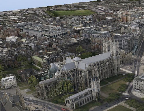
london in 3D

Skape Facts:

* 12 – the number of UK cities mapped so far

* 4 – the number of planes in the Infoterra fleet

* 52 – the number of experts on the Skape testing panel

* 11 – the number of industries that could use Skape

* 14 – the number of applications for Skape

* 52,660 – the number of buildings mapped in total

* 23,947 – the number of buildings mapped in London

* 3,750 – the number of hours it took to map the centre of London

* 960 – the number of hours it took to map Birmingham

Jamie Ritchie, responsible for the launch of Skape, explains: "In today’s environment architects and planners are so dependent on modelling and 3D modelling. Their clients are demanding high quality, 3D visuals to bring concepts to life and to help them with their tendering and commissioning decisions. With Skape, highly realistic, complex modelling can now be done quickly and cost-effectively."

"Skape has been developed in conjunction with our user base, so we’ve called on an independent, expert panel of architects for feedback during the development process."

"During the feedback and development process, the majority of users viewed Skape as a significant improvement over current technology, showing that the market has been waiting for a service like Skape."

"The feedback has been extremely useful, and has meant that the service has been developed with our customer base constantly in mind. Skape will continually develop as we capture more and more data, and as our customers’ needs evolve."

Skape has already been used by Bournemouth Borough Council’s planning department to scope out a potential new regeneration project, allowing stakeholders to see a far more realistic visual concept than would have been possible previously, in the form of a flythrough of Bournemouth centre and 16 development sites.

"I am convinced Skape has a number of uses that will assist us in promoting the Town Centre Master Vision (TCMV) initiative and the Council’s wider aspirations for the Town." – Martin Tiffin, TCMV Programme Leader, Bournemouth Borough Council.

For more information on Skape visit www.skapeworld.com or for a free introductory credit, please call 0845 117 3030
 

Filed Under: Earth Imagery Tagged With: Infoterra launches interactive 3D city mapping service - a technological first, Infoterra launches interactive 3D city mapping service - a technological firstNews, News, R/S & Earth Imaging

About Editor

Glenn is a geographer and a GIS professional with over 20 years experience in the industry. He's the co-founder of GISuser and several other technology web publications.

Top Press

The Global Expansion of Aueshah: A New Era of High Jewelry

April 11, 2026 By GISuser

KARACHI, PAKISTAN. The international luxury market is experiencing a profound shift. Consumers are increasingly rejecting mass-produced goods in favor of rarity, authenticity, and emotional depth. … [Read More...]

State of Data Science Report – AI and Open Source at Work

September 10, 2025 By GISuser

AI and Open Source at Work … [Read More...]

Topcon Announces Landmark Expansion of Topnet Live Network Across USA

January 26, 2025 By GISuser

LIVERMORE, Calif.---Topcon Positioning Systems has announced a significant expansion of its Topnet Live reference station network, introducing 200 new geodetic stations strategically positioned across … [Read More...]

Space Flight Laboratory (SFL) Announces Launch and Deployment of NorSat-4 Maritime Monitoring Microsatellite

January 19, 2025 By GISuser

Seventh Satellite Developed by SFL for Norway … [Read More...]

HERE and BMW Group extend partnership on AI-powered mapping system

January 8, 2025 By GISuser

HERE and BMW Group extend partnership on AI-powered mapping system for automated driving and enhanced road safety … [Read More...]

Everest Base Camp Helicopter Tour, Helicopter Return Trek, and Manaslu Circuit Trek: Which Nepal Adventure Is Right for You?

November 6, 2026 By GISuser

Almost everyone planning a Nepal trip runs into the same wall. You want the big mountains, you have a fixed number of days, and every itinerary you read seems to promise something … [Read More...]

SFL Missions Inc. Confirms Successful Deployment of Six HawkEye 360 Radio Frequency Detection Satellites with Advanced Capabilities

October 27, 2026 By GISuser

MĀHIA, New Zealand, 26 October 2026 – SFL Missions Inc. today confirmed the successful deployment of six radio frequency (RF) detection and geolocation satellites for HawkEye 360 … [Read More...]

Canadian-Built RoadEng 12 Uses AI to Find the Best Location for New Resource and Rural Roads

October 17, 2026 By GISuser

Vancouver, BC, Canada, October 15, 2026 – North Vancouver-based Softree Technical Systems today released RoadEng Version 12, used in more than 75 countries to locate and design … [Read More...]

Beyond the Map: How AI Image and Video Generation Is Changing Geospatial Communication

October 14, 2026 By GISuser

Ask anyone who has shipped a GIS project what the hardest part was, and the answer is rarely the spatial analysis. It is almost always the communication. A site suitability … [Read More...]

From Maternity to Everyday Wear: Building a Wardrobe That Grows With You

October 14, 2026 By GISuser

When I think about maternity clothing, I feel the biggest mistake is buying too many things at once. During pregnancy, your body keeps changing, and something that fits well today … [Read More...]

Copyright gletham Communications 2015 - 2026

Go to mobile version