| |  | | Pitney Bowes Software and Data Marketplace Now Offering Data for Purchase Online
The Company will now offer licenses to over 1,500 geography-specific data sets for purchase online through the Pitney Bowes Software and Data Marketplace. The new offering is yet another proof point in the Company’s strategy to simplify commerce for customers, and invest in its growth businesses, such as Data licensing.
| |
| |  | | AT&T Helps You Track Just About Anything Anywhere
Asset Tracker One (AT1) can track nearly anything – from transportation and agriculture to food services, pharmaceuticals and emergency services. You can monitor your things through the Fleet Complete mobile app.
| |
| |  | | NOAA – Summer 2018 ranked 4th hottest on record for U.S.
In a tie with 1934, the Summer of 2018 ranked as the fourth hottest summer on record for the contiguous United States after three months of blistering temperatures. August 2018, meanwhile, finished as the 17th warmest August, as the Southwest and Northeast broiled under record heat.
| |
| |  | | Introducing Boundless Learning
Check out more than 60 elearning courses on Boundless products and open source tools including PostGIS and OpenLayers. You can purchase individual courses or subscribe to all content and save!
| |
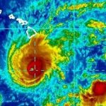
| | 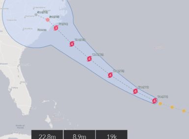 | | Around-the-Web - Tracking Hurricane Florence
During times of crisis, emergency, and destructive weather incidents, we look to real-time maps. They are a crucial component in emergency response, disaster monitoring, and reporting. Here's several resources to bookmark and help you stay informed and safe
| |
| |