| |  | | Webinar – A Smarter GIS with Esri Mobile Apps & Spike Photo Measurement, Wed. Jan 16
Is mobile field data collection too hard or too expensive for your organization? Join ikeGPS for a free webinar today to learn about how Spike, a smart laser measurement solution, with Esri Mobile Apps is a cost-effective and common-sense mobile field data collection solution for the Esri user community. Registrants will receive a special offer on their purchase of Spike.
| |
| |  | | Hexagon’s Geospatial Division Releases Luciad V2018.1
V2018.1 focuses on further expanding 3D capabilities and includes additional data formats and standards for users in military and maritime domains. To accommodate organizations’ expanding geospatial data, LuciadFusion introduces a RESTful API to automate the entire process of data crawling.
| |
| | 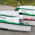 | |
Seabotics Completes First HYCAT Production Run
SeaRobotics Corporation (SeaRobotics) today announced that it has completed the first production run of the HYCAT Autonomous Surface Vehicle (ASV) in partnership with Xylem, USA. This unique ASV, offered by both Xylem and SeaRobotics, provides exceptional tools leading to an out of the box plug and play survey solution.
|
|
| |  | | URISA Announces 2019-2020 Vanguard Cabinet of Young Professionals
URISA is pleased to announce the newest members of its Vanguard Cabinet. The Vanguard Cabinet (VC) is a URISA initiative (which debuted in 2011) to engage young GIS practitioners, increase their numbers in the organization, and better understand the concerns facing these future leaders of the GIS community.
| |
| | 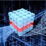 | | German DIN Supports Foundations of Datacubes
What is a coverage, after all? This fundamental spatio-temporal data structure, encompassing (among others) datacubes, is widely used, based on adopted and implemented OGC and ISO standards like WCS. However, the conceptual foundations are outdated. This is being changed now.
| |
| |  | | USGIF Now Accepting Nominations for its 2019 Awards Program
The USGIF Awards Program annually recognizes the exceptional work of the global geospatial intelligence (GEOINT) tradecraft’s brightest minds and most innovative organizations. The program shines a spotlight on outstanding GEOINT achievements in five categories: academic, community support, government, industry, and military.
| |
| |