GIS user technology news

News, Business, AI, Technology, IOS, Android, Google, Mobile, GIS, Crypto Currency, Economics

  • Advertising & Sponsored Posts
    • Advertising & Sponsored Posts
    • Submit Press
  • PRESS
    • Submit PR
    • Top Press
    • Business
    • Software
    • Hardware
    • UAV News
    • Mobile Technology
  • FEATURES
    • Around the Web
    • Social Media Features
    • EXPERTS & Guests
    • Tips
    • Infographics
  • Blog
  • Events
  • Shop
  • Tradepubs
  • CAREERS
You are here: Home / * PRESS / Environment / Satellites Capture Smoky Skies in North America

Satellites Capture Smoky Skies in North America

August 22, 2018 By GISuser

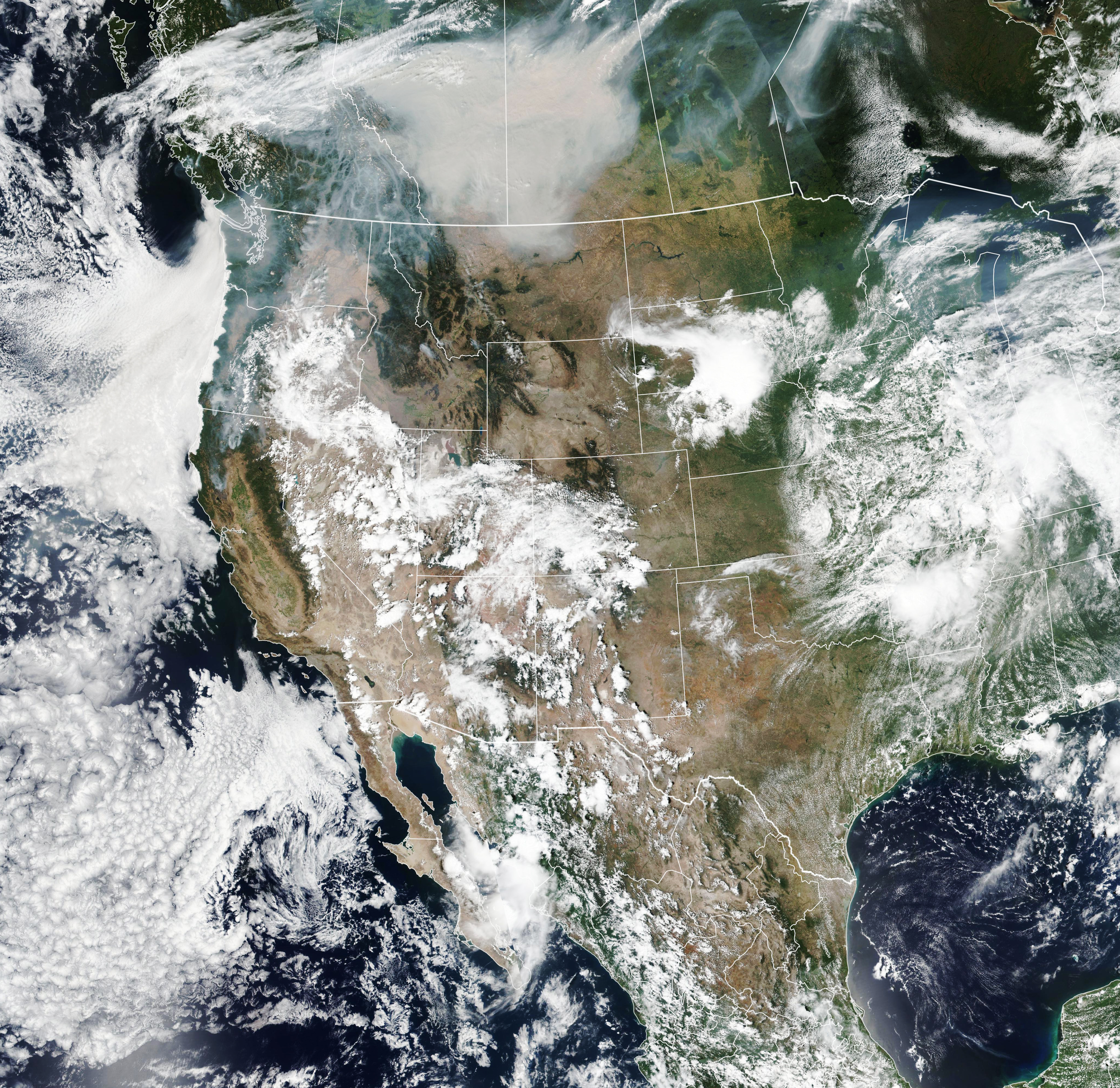
In mid-August 2018, deadly blazes across the western United States and Canada continued to destroy structures and disrupt the lives of millions of people. But you did not have to be close to the fires to witness its effects. These images show just how far across North America winds have carried the thick plumes of smoke.
Smoky Skies in North America

August 15, 2018

The Visible Infrared Imaging Radiometer Suite (VIIRS) on the Suomi NPP satellite acquired this image (top) on August 15, 2018. Smoke is seen hovering over much of western North America and central Canada.

Much of the smoke and associated pollution rises high into the atmosphere, where it does not pose an immediate threat to people. For example, the carbon monoxide released from California fires drifted high in the atmosphere toward eastern North America. (Eastern areas are more likely to be affected at the surface, as winds bring the pollutant back down.)
August 15, 2018JPEG

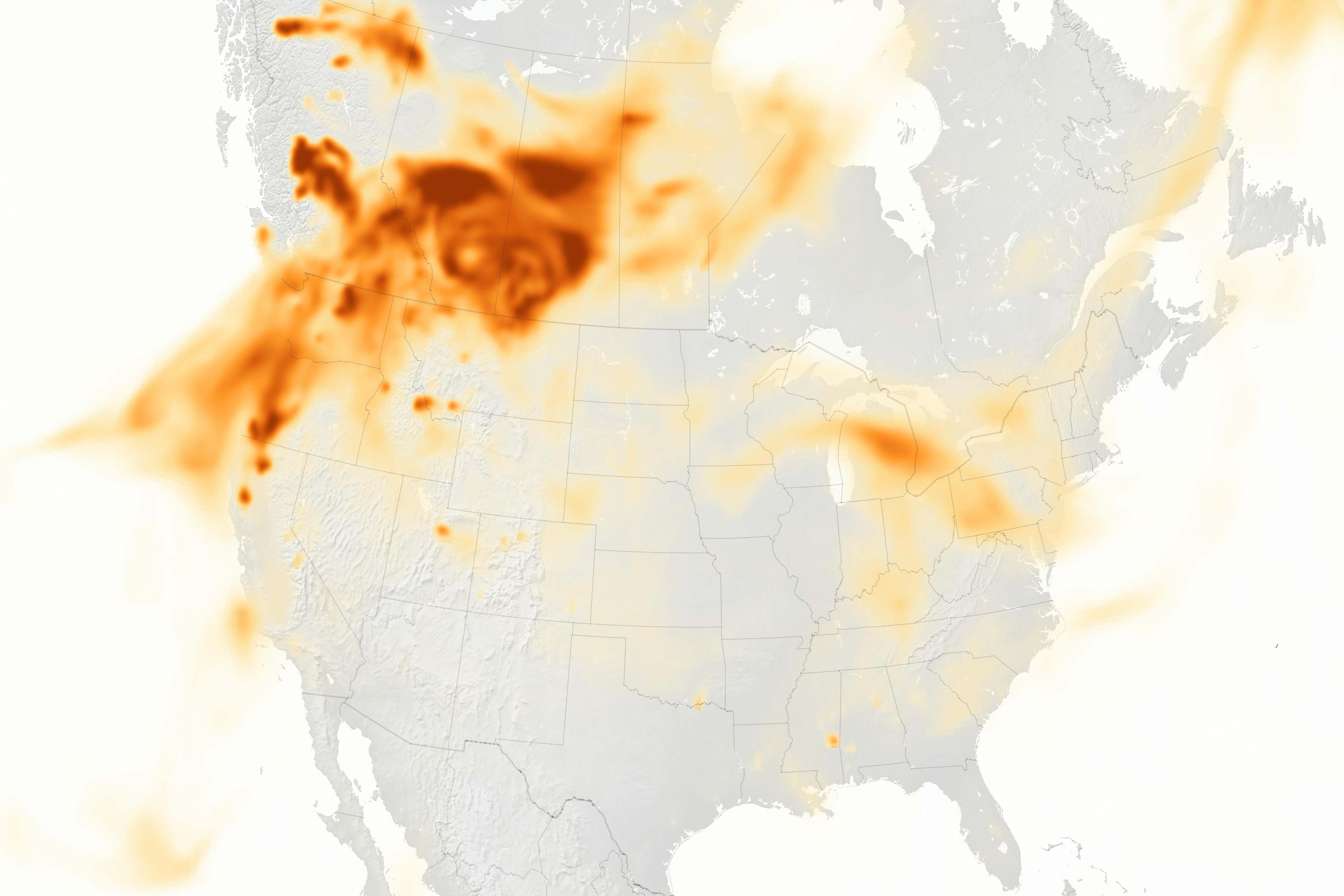
Wildfires also can produce black carbon pollution. This sooty black material comes from the incomplete combustion of fossil fuels and vegetation, and it is easily transported by winds. Black carbon can cause respiratory and cardiovascular problems if inhaled, and it can also affect climate. The map above shows plumes of black carbon associated with the western wildfires on August 15. Data for the map come from the GEOS-5 forward processing model.

Plenty of smoke and airborne particles have been measured near the ground, where it affects the air that people breathe. According to the National Weather Service in Seattle, the air quality in Washington state on August 15 was the worst in the country due to winds carrying smoke from surrounding fires. Atmospheric scientist Cliff Mass reported that in the Seattle area, the 24-hour average concentration of fine particles (PM 2.5) was the worst on record. The next day, an onshore wind flow helped push out the smoke and forecasters expected conditions to improve.

Air quality that day also reached “unhealthy” levels across parts of Northern California, Oregon, Idaho, and Montana, according to the Environmental Protection Agency’s air quality index. Unhealthy levels indicate that everyone breathing the air could potentially feel adverse health effects.

Meanwhile, vast plumes of smoke rose from more than 500 wildfires burning in British Columbia, prompting the provincial government to declare a state of emergency. The thick plumes also yellowed the skies and degraded air quality in provinces to the east in Alberta, Saskatchewan, and Manitoba.
August 15, 2018JPEG

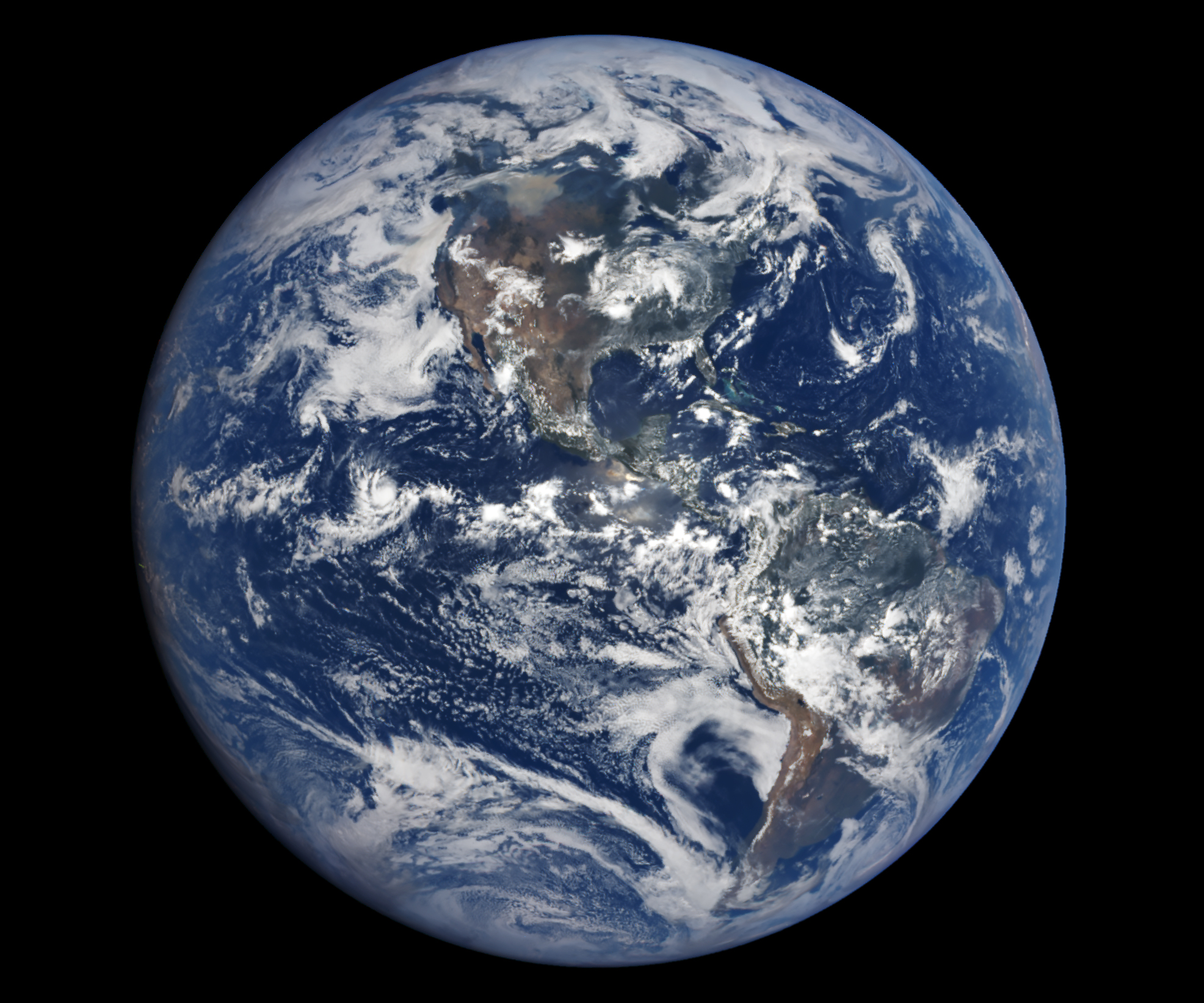
The smoke from Canadian fires was so pronounced it was visible from a distance of about 1.5 million kilometers (1 million miles) away. That’s the distance of NASA’s Earth Polychromatic Imaging Camera (EPIC) on NOAA’s DSCOVR satellite, which acquired the second image on August 15.

NASA Earth Observatory images by Lauren Dauphin, using VIIRS data from the Suomi National Polar-orbiting Partnership, GEOS-5 data from the Global Modeling and Assimilation Office at NASA GSFC, and data from DSCOVR EPIC. Story by Kathryn Hansen.

Source: EarthObservatory

Filed Under: Environment Tagged With: wildfire

Top Press

The Global Expansion of Aueshah: A New Era of High Jewelry

April 11, 2026 By GISuser

KARACHI, PAKISTAN. The international luxury market is experiencing a profound shift. Consumers are increasingly rejecting mass-produced goods in favor of rarity, authenticity, and emotional depth. … [Read More...]

State of Data Science Report – AI and Open Source at Work

September 10, 2025 By GISuser

AI and Open Source at Work … [Read More...]

Topcon Announces Landmark Expansion of Topnet Live Network Across USA

January 26, 2025 By GISuser

LIVERMORE, Calif.---Topcon Positioning Systems has announced a significant expansion of its Topnet Live reference station network, introducing 200 new geodetic stations strategically positioned across … [Read More...]

Space Flight Laboratory (SFL) Announces Launch and Deployment of NorSat-4 Maritime Monitoring Microsatellite

January 19, 2025 By GISuser

Seventh Satellite Developed by SFL for Norway … [Read More...]

HERE and BMW Group extend partnership on AI-powered mapping system

January 8, 2025 By GISuser

HERE and BMW Group extend partnership on AI-powered mapping system for automated driving and enhanced road safety … [Read More...]

Everest Base Camp Helicopter Tour, Helicopter Return Trek, and Manaslu Circuit Trek: Which Nepal Adventure Is Right for You?

November 6, 2026 By GISuser

Almost everyone planning a Nepal trip runs into the same wall. You want the big mountains, you have a fixed number of days, and every itinerary you read seems to promise something … [Read More...]

SFL Missions Inc. Confirms Successful Deployment of Six HawkEye 360 Radio Frequency Detection Satellites with Advanced Capabilities

October 27, 2026 By GISuser

MĀHIA, New Zealand, 26 October 2026 – SFL Missions Inc. today confirmed the successful deployment of six radio frequency (RF) detection and geolocation satellites for HawkEye 360 … [Read More...]

Canadian-Built RoadEng 12 Uses AI to Find the Best Location for New Resource and Rural Roads

October 17, 2026 By GISuser

Vancouver, BC, Canada, October 15, 2026 – North Vancouver-based Softree Technical Systems today released RoadEng Version 12, used in more than 75 countries to locate and design … [Read More...]

Beyond the Map: How AI Image and Video Generation Is Changing Geospatial Communication

October 14, 2026 By GISuser

Ask anyone who has shipped a GIS project what the hardest part was, and the answer is rarely the spatial analysis. It is almost always the communication. A site suitability … [Read More...]

From Maternity to Everyday Wear: Building a Wardrobe That Grows With You

October 14, 2026 By GISuser

When I think about maternity clothing, I feel the biggest mistake is buying too many things at once. During pregnancy, your body keeps changing, and something that fits well today … [Read More...]

Copyright gletham Communications 2015 - 2026

Go to mobile version