GIS user technology news

News, Business, AI, Technology, IOS, Android, Google, Mobile, GIS, Crypto Currency, Economics

  • Advertising & Sponsored Posts
    • Advertising & Sponsored Posts
    • Submit Press
  • PRESS
    • Submit PR
    • Top Press
    • Business
    • Software
    • Hardware
    • UAV News
    • Mobile Technology
  • FEATURES
    • Around the Web
    • Social Media Features
    • EXPERTS & Guests
    • Tips
    • Infographics
  • Blog
  • Events
  • Shop
  • Tradepubs
  • CAREERS
You are here: Home / * PRESS / Developer / Engility holds app development contest for the Innovative GEOINT Application Provider Program (IGAPP) participants

Engility holds app development contest for the Innovative GEOINT Application Provider Program (IGAPP) participants

May 18, 2016 By Editor

Engility Participates in Ceremony to Present $25,000 Award to Optensity, Inc. for Prize Winning App
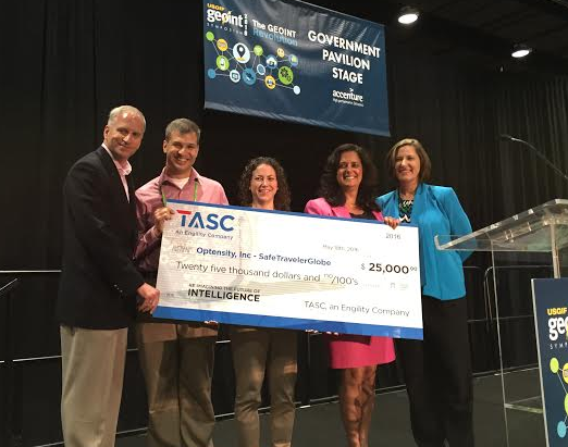
Screenshot 2016-05-18 at 2.51.26 PM

ORLANDO, Fla., May 18 – Engility Holdings, Inc. (NYSE:EGL), named Optensity, Inc. the winner of the Innovative GEOINT Application Provider Program (IGAPP) Grand Challenge 2016 during the United States Geospatial Intelligence Foundation’s 2016 (GEOINT) Symposium, in Orlando, FL.

“Engility is pleased to recognize Optensity, Inc. as the winner of the IGAPP Grand Challenge 2016, which is already available for download in the NGA GEOINT App Store,” said Brownfield. “The judges reviewed and tested the submitted apps, and found that SafeTravelerglobe App best satisfies the challenge objectives. We thank all the vendors who participated and submitted apps.”

Amanda Brownfield, Engility Senior Vice President for National Intelligence Accounts, and National Geospatial-Intelligence Agency Director Robert Cardillo presented a $25,000 check to Optensity, Inc., which developed the SafeTravelerGlobe App.

SafeTravelerglobe App helps users acclimate to a new area by alerting users if a threat exists, determines safe locations (e.g. Embassy, consulate) and reviews critical information needed for a quick and safe response. It also has a map display that shows official information (e.g. Department of State warnings and alerts, PlanetRisk real time threat feed, embassy and consulate locations and cultural facts) vital to safety.

“We are proud Engility was able to partner with NGA to create the IGAPP Grand Challenge 2016,” said Engility CEO Lynn Dugle. “IGAPP captures the creativity of commercial application developers and serves as an important bridge between industry and the U.S. government. The Grand Challenge plays an important role in increasing awareness and interest in the NGA GEOINT App Store.”

IGAPP Grand Challenge 2016 was announced in February 2016 at the IGAPP Developers Conference. Event attendees were given a vendor opportunity package, which outlined the challenge objectives and the evaluation criteria – meet mission needs, user experience, functionality and quality.

IGAPP serves as a trusted broker bridging the gap between commercial vendors and government agencies who are interested in acquiring innovative technologies. In this capacity, IGAPP identifies, prequalifies and approves vendors to participate in the program.  IGAPP offers expertise to assist vendors through the App submission process, and provides the infrastructure to support App testing and evaluation to ensure App security and performance. Apps that progress through the IGAPP Program are recommended for and released to NGA’s GEOINT App Store.

About Engility

Engility (NYSE: EGL) is engineered to make a difference. Built on five decades of heritage, Engility is a leading provider of integrated solutions and services for the U.S. government, supporting customers throughout defense, intelligence, space, federal civilian and international communities. Engility delivers world-class performance, efficiency and best value in a broad range of services from global security to information security, and international development to research and development. Headquartered in Chantilly, Virginia, and with offices around the world, Engility draws upon its intimate understanding of customer needs, deep domain expertise, and skilled team to develop and deliver on-target solutions for critical missions. To learn more about Engility, please visit www.engilitycorp.com and connect with us on Facebook, LinkedIn and Twitter.

Filed Under: Developer Tagged With: developer, GeoINT, hackathon

About Editor

Glenn is a geographer and a GIS professional with over 20 years experience in the industry. He's the co-founder of GISuser and several other technology web publications.

Top Press

The Global Expansion of Aueshah: A New Era of High Jewelry

April 11, 2026 By GISuser

KARACHI, PAKISTAN. The international luxury market is experiencing a profound shift. Consumers are increasingly rejecting mass-produced goods in favor of rarity, authenticity, and emotional depth. … [Read More...]

State of Data Science Report – AI and Open Source at Work

September 10, 2025 By GISuser

AI and Open Source at Work … [Read More...]

Topcon Announces Landmark Expansion of Topnet Live Network Across USA

January 26, 2025 By GISuser

LIVERMORE, Calif.---Topcon Positioning Systems has announced a significant expansion of its Topnet Live reference station network, introducing 200 new geodetic stations strategically positioned across … [Read More...]

Space Flight Laboratory (SFL) Announces Launch and Deployment of NorSat-4 Maritime Monitoring Microsatellite

January 19, 2025 By GISuser

Seventh Satellite Developed by SFL for Norway … [Read More...]

HERE and BMW Group extend partnership on AI-powered mapping system

January 8, 2025 By GISuser

HERE and BMW Group extend partnership on AI-powered mapping system for automated driving and enhanced road safety … [Read More...]

Canadian-Built RoadEng 12 Uses AI to Find the Best Location for New Resource and Rural Roads

October 17, 2026 By GISuser

Vancouver, BC, Canada, October 15, 2026 – North Vancouver-based Softree Technical Systems today released RoadEng Version 12, used in more than 75 countries to locate and design … [Read More...]

Beyond the Map: How AI Image and Video Generation Is Changing Geospatial Communication

October 14, 2026 By GISuser

Ask anyone who has shipped a GIS project what the hardest part was, and the answer is rarely the spatial analysis. It is almost always the communication. A site suitability … [Read More...]

From Maternity to Everyday Wear: Building a Wardrobe That Grows With You

October 14, 2026 By GISuser

When I think about maternity clothing, I feel the biggest mistake is buying too many things at once. During pregnancy, your body keeps changing, and something that fits well today … [Read More...]

eMMC 5.1 Explained: Features, Performance, and Applications in Modern Devices

October 14, 2026 By GISuser

Storage technology is an essential part of modern computing, influencing how devices store information, launch applications, and manage everyday workloads. Although … [Read More...]

SFL Missions Inc. Confirms Successful Deployment of Two GHGSat Greenhouse Gas Monitoring Microsatellites

October 3, 2026 By GISuser

TORONTO, Ontario, Canada, 2 October 2026 – SFL Missions Inc. confirms the successful launch and deployment of the GHGSat-C18 (Eleanor) and GHGSat-C19 (Aidan) commercial greenhouse … [Read More...]

Copyright gletham Communications 2015 - 2026

Go to mobile version