Over the past 10 years, Jason Gilliland and his team at the Human Environments Analysis Laboratory (HEAL) at Western University have been conducting studies into what causes obesity in southern Ontario.
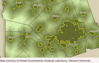
They have created maps, such as those pictured here, to help them do so. Gilliland, director of HEAL, explains how his research is being used to identify the geographic and socioeconomic links to healthy eating. Gilliland says that public health officials from counties in southwestern Ontario are his map in the development of policies and strategies that will improve the access to supermarkets in some regions. In London, Ont., for example, his research will be used to help achieve the city’s goal of eradicating food deserts by 2020. Gilliland and his team looked at how far Middlesex County homes were from parks, arenas and other public facilities to determine the recreational opportunities in the region. He says that the importance of this kind of mapping — one of 400 similar maps he and his team have created — is that it shows where child obesity is more likely to be present. He hypothesizes that people in the darker green areas and within the yellow lines (closest to recreational spaces) are more likely to be physically active and less likely to be overweight