Applications and Integration Center expands flexibility to encompass gunshot detection with aerial-map presentation capabilities Continue reading “DVTEL Latitude NVMS Now Integrated With ShotSpotter, GoogleEarth”
Category: Google maps, Google earth, Web 2.0 Map Resources
GE and Google Agreement Allows Utilities Anywhere to Tap Familiar, Easy-to-Use Maps Platform
GE and Google Agreement Allows Utilities Anywhere to Tap Familiar, Easy-to-Use Maps Platform to Boost Productivity Continue reading “GE and Google Agreement Allows Utilities Anywhere to Tap Familiar, Easy-to-Use Maps Platform”
Adapx Announces New Speech and Sketch Interfaces for Faster Mission Planning With Google Earth
Adapx Announces New Speech and Sketch Interfaces for Faster Mission Planning With Google Earth, Command Post of the Future, and The Army’s Replay Application Framework – AUSA Exposition Attendees Will Be Able to Capture Data Into Existing C4ISR and Command and Control Systems by Speaking and Sketching Standard Military Jargon and Symbols Continue reading “Adapx Announces New Speech and Sketch Interfaces for Faster Mission Planning With Google Earth”
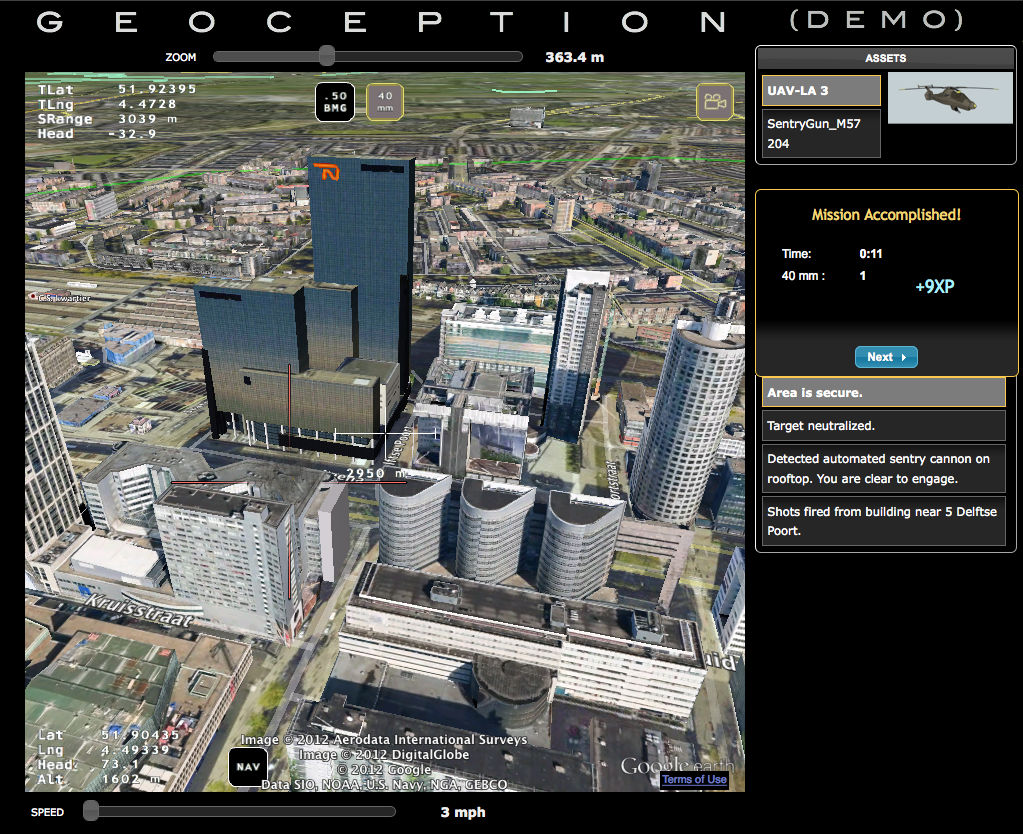
NEW VIDEO GAME AIMS TO CREATE REALISTIC COMBAT DRONE SIMULATOR USING GOOGLE EARTH
Austin, TX, October 9, 2012 – A new game in development promises to leverage the technology of Google Earth to offer players the largest explorable map in video game history. "Geoception", by Earthling Technology, allows players to command and control UAVs and other combat drones in a realistic manner, anywhere in the world.
Tactical scenarios and missions can be dynamically generated at any location on the globe, providing challenging targets such as armed personnel, moving vehicles, and rooftop sentry guns. Successful completion of missions earns rewards and medals, with the ultimate goal being to establish total global security.
All game actors can be easily replaced with virtually any Sketchup/3D models of the player’s choosing, allowing a totally customizable gaming experience. You can replace the drones with dragons, or the soldiers with Smurfs. It’s your world, and your game. Craft your own actor models in Sketchup, or choose from a wide selection of free models in 3DWarehouse – even zombies!
And with Google continuously improving the quality of their digital globe behind the scenes, the player is guaranteed an ever-improving game map and environment. This new concept of "reality gaming" – i.e, gaming in a realistic model of the actual world we live in – truly has the potential to revolutionize the way people think of video games.
More information is available at:
- http://geoception.com
- http://www.kickstarter.com/projects/945876709/geoception-reality-gaming-in-google-earth
ABOUT EARTHLING TECHNOLOGY, LLC
Earthling Technology, LLC is an Austin, Texas-based software development company specializing in original video games. Their first release is Geoception, a novel Google Earth-based game in development that allows the player to command and control combat drones anywhere in the world.

GEOCEPTION: NEW VIDEO GAME AIMS TO CREATE REALISTIC COMBAT DRONE SIMULATOR USING GOOGLE EARTH
Google Maps Heads Indoors at the Smithsonian and other Museums
Some cool updates from the Google UK team as they’ve announced more indoor mapping efforts, this time at the museum – 20 of them actually!
Continue reading “Google Maps Heads Indoors at the Smithsonian and other Museums”
NexTraq Featured in Google Maps Video Case Study
Google showcases NexTraq Fleet Tracking platform in video case study Continue reading “NexTraq Featured in Google Maps Video Case Study”
NASA Workshop – Google Geospatial Seminar
Date : May 1, 2012 Time : 9am – 3pm
Location: StenniSphere
NASA’s Applied Science & Technology Project Office at Stennis Space Center will host the Google Geospatial Seminar. Learn about powerful, easy-to-use geospatial tools such as…
o Google Fusion Tables
o Familiar spreadsheet interface
o Automatically geocode your data
o Easily perform spatial queries across multiple data sets
o Create maps, plots and graphs
o Data attribution is built in
o Effortlessly export data to web pages and Google Earth
o Google Earth
o Data visualization
o Animations o Customization
o Google tools and APIs to automate Google Fusion Table and Google Earth applications
http://science.community.nasa.gov/home/workshops/geospatial-seminar-reg
Google Politics and Election 2012 Maps, Results, G+ and more
For those looking to follow the 2012 US Election, look no further than Google and the Google Election Results map and data resource
Continue reading “Google Politics and Election 2012 Maps, Results, G+ and more”
emapsite solution helps keep shine on solar investment
Domestic solar power companies responding to a UK government subsidy cut are turning to an innovative digital map solution for help.
From April 2012 Feed-in-tariffs for small-scale household installations made after 12 December 2011 will be halved from 43p per kWh to 21p.
As a result, companies have to focus even harder on being efficient in identifying suitable roof space for photovoltaic panels.
emapsite, a leading provider of online digital mapping and location intelligence, has created a hosted, transactional web solution.
It helps companies identify as many eligible roofs as they can, as quickly as they can, and at minimal cost per unit.
Designed to work through a layer of Google Earth, the solution enables users to quickly assess roof criteria such as aspect, size, obstructions, pitch and solar capacity.
It then provides addresses for the relevant properties so that companies can contact householders and manage orders.
Where interest is shown, the solution generates professional-standard annotated site plans for notifying planning authorities.
One of the first customers was Solar2Energy, which aggregates bundles of suitable residential properties on behalf of investment funds.
It has a network of ten installation companies working on around 1,000 properties a month across most of England and Wales.
Solar2Energy Managing Director Caroline Joseph said: “We use emapsite’s hosted solution to help us pin down the properties we have identified through desktop surveys and validate that they are suitable. Once through that process, we also use the solution to put all the documentation together and produce our planning application maps. It’s a very practical tool that gives us instant output. Emapsite makes it very easy for us to offer these partners a consistent, professional presentation.”
Another customer is the leading free energy provider FreeSolar. Rod Hughes, Managing Director, said emapsite’s input is helping his team gain installation contracts with around 2,000 residential properties across the country every month.
He said: “We are working very closely with emapsite on a unique system that identifies and quantifies suitable properties in a semi-automated way using graphic information. It enables us to go in and change views, drilling down into more and more detail. We use the information as part of what we need to do to prequalify jobs. The benefits of our hosted solution are speed, 24-hour access and accuracy of information. We can also develop add-on services for customisation as required.”
James Cutler, emapsite CEO, said: “The cut in Feed-in-Tariffs has led most domestic solar companies to review their business plans and profit forecasts. Many now need to focus even harder on being efficient. The upside is that geospatial technology is well placed to support that renewed drive. Our solution is ideal as users require no specialist GIS knowledge. Since it is hosted, there are also no data storage, content management or licensing worries.”
For more information from emapsite, visit www.emapsite.com.
Attitash & Wildcat Mountain Among First Google Street View Map Ski Areas in the East
Bartlett, NH, December 01, 2011 — Wildcat Mountain and Attitash Mountain Resort were recently included among hundreds of new imagery maps released in Google’s Street View collections. The New Hampshire resorts had allowed and coordinated with Google their visit to the mountains and assisted with their collecting 360-degree imagery of the ski slopes, trails and facilities at each resort.
“We were excited to have been asked and to work with the Google Street View team in late March and early April of 2011 and to have them capture this unique imagery of Wildcat Mountain and Attitash Mountain Resort,” said Thomas Prindle, Director of Marketing for both Attitash & Wildcat Mountain. “This new virtual experience has the potential to allow millions of people to view it wherever they are in the world. With imagery of our resort available in Street View, ski and snowboard enthusiasts who may not have visited our mountains or the Mount Washington Valley can now explore the slopes from afar. Ultimately, this helps us showcase the resorts more easily and hopefully, encourage more people to want to visit and see the real thing.”
Street View is a feature available in Google Maps, Google Earth and Google Maps for Mobile that allows users to explore the world virtually at street level. The Google Street View imagery captured at Wildcat Mountain and Attitash Mountain Resort was possible utilizing Google’s specially designed camera systems that they mounted on a snowmobile that enabled a resort employee to navigate ski trails while capturing 360-degree imagery.
To see and experience the Google Street View ski area map for Wildcat Mountain, visit: http://bit.ly/WildcatMountain_GoogleStreetView.
For Attitash, visit: http://bit.ly/AttitashMountain_GoogleStreetView.
###
Attitash Mountain Resort, located in the Mount Washington Valley, has most recently been ranked amongst the East’s top ten ski resorts for grooming, weather, accessibility, and off-hill activities by readers of SKI Magazine. Offering two distinct mountains, Attitash and Bear Peak, and one of New England’s most advanced snow making systems, Attitash is known for its signature terrain parks, ski school and children’s programs, open-glade terrain, après entertainment, family value, the year-round mountain coaster attraction, and quality slopeside accommodations featuring the Attitash Grand Summit Hotel. For further information, please visit www.attitash.com or call 1-800-223 SNOW.
Wildcat Mountain, a year-round destination located 100% within the White Mountain National Forest in Pinkham Notch, is home to New Hampshire’s most powerful quad summit chair lift and is renowned for its high summit elevation over 4,000 feet and greater than 2,100 vertical feet of skiing and riding; longest novice trail in the state at just under 3 miles; and proximity to Mt. Washington that contributes up to 200 inches of snow and a long winter/spring season annually. Wildcat Mountain has consistently been rated #1 Scenery and Top Ten in the East for Snow, Terrain Challenge, and Value by readers of SKI Magazine. For further information, please visit www.skiwildcat.com or call 1-888-SKI WILD.