GIS user technology news

News, Business, AI, Technology, IOS, Android, Google, Mobile, GIS, Crypto Currency, Economics

  • Advertising & Sponsored Posts
    • Advertising & Sponsored Posts
    • Submit Press
  • PRESS
    • Submit PR
    • Top Press
    • Business
    • Software
    • Hardware
    • UAV News
    • Mobile Technology
  • FEATURES
    • Around the Web
    • Social Media Features
    • EXPERTS & Guests
    • Tips
    • Infographics
  • Blog
  • Events
  • Shop
  • Tradepubs
  • CAREERS
You are here: Home / * PRESS / DATA / LandScan+ for GIS Analysis

LandScan+ for GIS Analysis

December 11, 2015 By GISuser

East View is pleased to introduce a new geospatial solution by combining authoritative infrastructure data with the LandScan Global Population Database.

landscan

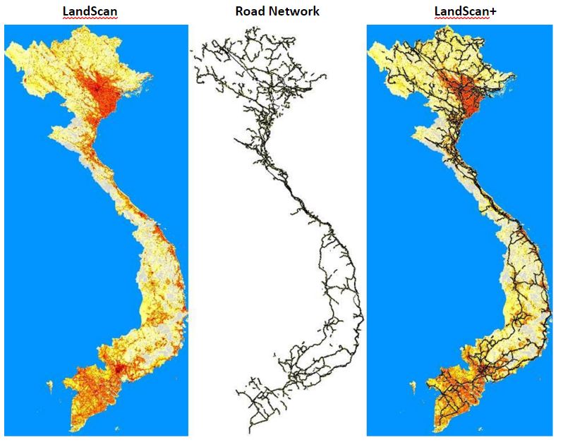
LandScan Vietnam (left) and the Vietnam Road Network (middle) are combined to generate the LandScan+ image (right)

LandScan provides the most accurate and reliable ambient population data covering the globe.

LandScan+ is a new opportunity for GIS users to improve their ability to analyze the impact of conditions, surroundings and events on human population dynamics.

Since 1989, East View has acquired a vast archive of global maps and geospatial datasets* that can now be paired with LandScan population data.

Here is one example:

Vietnam 1:50K Topographic Vector Data 

  • Road Network
  • Rail Network
  • Power Utilities
  • Hydro Network
  • Cultural Sites

* These datasets were not used in the creation of LandScan, which is developed by the Oak Ridge National Laboratory.

See the Landscan Brochure HERE

Landscan Documentation

See www.geospatial.com

Filed Under: DATA, DATA FEATURES, Top Press Tagged With: LandScan

Editor’s Picks

Botswana Geoscience Portal goes live

Esri Indonesia Story Map Explores Missing AirAsia Flight 8501

Feature – GIS and the NFL: Sustainability and Millennial Fans

World LiDAR Market is Expected to Reach $921.2 Million by 2022 – Allied Market Research

See More Editor's Picks...

Recent Industry News

Why Bathroom Renovation Services Often Change More Than Just the Bathroom

May 20, 2026 By GISuser

The Drift Between Early Notes and Final Case Files in Abuse-Related Legal Support

April 29, 2026 By GISuser

Aerial Surveys Int’l and Global Marketing Insights to Present GEOINT 2026 Workshop on Multi-Domain Geospatial Fusion for Automated Infrastructure Monitoring

April 24, 2026 By GISuser

Why Timing Matters More Than You Think With Spray Seal (And Why People Often Get It Slightly Wrong)

April 22, 2026 By GISuser

Hot News

State of Data Science Report – AI and Open Source at Work

HERE and AWS Collaborate on New HERE AI Mapping Solutions

Virtual Surveyor Adds Productivity Tools to Mid-Level Smart Drone Surveying Software Plan

Categories

Copyright gletham Communications 2015 - 2026

Go to mobile version