
OTTAWA, May 14, 2019 /CNW/ – By driving innovation in communities across the country, the Government of Canada is empowering communities to address the most pressing needs of their residents through data and connected technology.
Archives for May 15, 2019
How GIS Data is Used in the Business World
Geospatial data is just about everywhere. It includes imagery, features, and base maps. This information changes our perception of what we know and what is happening.
Esri Announces Significant Expansion in St. Louis to Serve Rapidly Growing Geospatial Market
Staff Expansion of Esri Presence Will Serve Users across Many Industries
OS moon map celebrates 50th anniversary of the moon landing
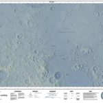
This year marks the 50th year anniversary of the moon landing, and to celebrate and mark the occasion the OS GeoDataViz team thought it would be fitting to create a map of Apollo 11’s lunar landing site in our unique map style.Find out how Paul Naylor approached the task.
Geodata – the currency of the future centre stage at INTERGEO 2019
From 17 to 19 September in Stuttgart, more than 680 exhibitors will be providing insights into the highly dynamic geospatial sector / The conference deals with the growing importance of geodata and the resulting opportunities / Key focuses are drones, smart cities and BIM / Presale tickets released for the industry’s most important event worldwide
Topcon accepts John Deere Supplier Innovation Award
LIVERMORE, Calif., U.S./ CAPELLE A/D IJSSEL, the Netherlands – May 14, 2019 – Topcon Positioning Systems has been selected as a recipient of the John Deere Innovation award for 2018. The Innovation awards are part of Deere & Company’s Achieving Excellence program.