GISuser.com

GIS and Technology news for mapping professionals

  • PRESS
    • Submit PR
    • Top Press
    • Business
    • GIS, Geo Tech Software
    • Hardware
    • UAV News
    • Mobile Technology
    • Editor’s Top Picks
    • Get TOP Listing!
  • FEATURES
    • GeoGeeksinCars
    • 10 Question Q&A
    • FROM THE EDITOR
    • SPATIAL MEDIA AUTHORS
    • Social Media Features
    • EXPERTS & Guests
    • Listicles and Top 10 Lists
    • Infographics
    • VIDEOS
  • Events
    • Webinars
    • Submit event
    • Event Media Partner
  • CAREERS
    • Career Help Articles
    • People and Career News
    • Work from Home
    • About GeoJobs.BIZ
  • About
    • Advertise
      • Advertise wth GISuser
      • Media Kit Request Form
      • Directory
      • Submit Press
    • Contact GISuser
    • Meet the Editor
    • Social Media
      • AnyGeo Blog
      • GeoGeeks Podcast
      • Social Media Features
      • Like Us
    • SpatialMedia
      • LBSzone
      • LiDAR Magazine
      • Amerisurv
      • SymbianOne
    • RSS feed
  • Blog
  • Shop
  • Cloud Hosting
    • Amazon Cloud Hosting
    • WordPress cloud hosting
    • Dedicated servers USA
    • Linux Shared Hosting
    • Windows Shared Hosting
    • Web Development
    • SSL Certificate
  • Tradepubs
You are here: Home / * PRESS / Hardware / DJI Introduces Mavic Air For Limitless Exploration Wherever Adventure Takes You

DJI Introduces Mavic Air For Limitless Exploration Wherever Adventure Takes You

January 23, 2018 By GISuser

The Most Portable 3-Axis Gimbal 4K Camera Drone Features SmartCapture, FlightAutonomy 2.0 and Advanced Pilot Assistance System

DJI, the world’s leader in civilian drones and aerial imaging technology, today introduced Mavic Air, an ultra-portable, foldable camera drone that delivers higher performance, more intelligent features and greater creative possibilities than any other consumer drone. Developed with the traveler and outdoor enthusiast in mind, Mavic Air inherits the best features of DJI’s iconic Mavic series with a 4K camera for superior image quality, new QuickShot modes and SmartCapture for easier, more intelligent photo and video capturing, and FlightAutonomy 2.0 with Advanced Pilot Assistance Systems for smarter, safer flight. A marvel of engineering and design, Mavic Air enables limitless exploration wherever adventure takes you.

“When DJI introduced the Mavic Pro, it reinvented what a consumer drone could be: powerful, yet portable, accessible, but advanced,” said Roger Luo, President at DJI. “Today, with the introduction of Mavic Air, we have pushed these attributes to the next level to create our best consumer drone yet.”

Designed for Portability and Power

Weighing just 430 grams, Mavic Air is the most portable DJI drone ever created. Its folding arms and propellers sit flush against its slender aerodynamic frame, making it so compact that its footprint is nearly the size of a modern smartphone when folded.

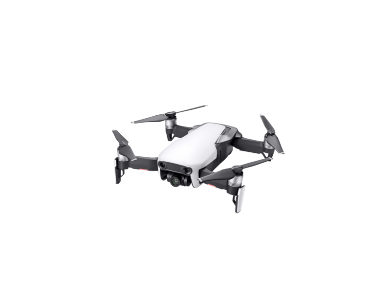
Every aspect of Mavic Air’s camera has been designed for maximum performance. Its recessed three-axis mechanical gimbal is suspended from dampeners to further reduce vibration providing superior protection and steadier shots.  A powerful camera housing a 1/2.3” CMOS sensor and the equivalent of a 24mm F2.8 lens (on a 35mm full frame sensor) captures high-quality photos and videos.

Mavic Air photographs crisp 12-megapixel still images utilizing new HDR algorithms that preserve more highlight and low light details, allowing you to capture stunning aerial pictures from sunrise to sunset. It also shoots smooth stabilized 4K video at 30 fps, capturing the highest quality video of any DJI consumer drone with a maximum bitrate of 100 Mbps. Preserving the action in dramatic fast-paced scenes is now possible through its ability to shoot 1080p slow-motion video at 120 fps.

Mavic Air is DJI’s first drone with 8 GB of onboard storage letting you save photos and videos directly to the aircraft on the go, plus a micro SD card slot for additional storage capacity. The newly-added USB-C port makes exporting captured footage easy and fast.

Expand Your Creativity

Mavic Air’s intelligent camera system creates new possibilities for anyone regardless of their photography and drone piloting experience. Photo enthusiasts who want to capture their surroundings in complete detail can use the new Sphere panorama feature to automatically shoot and stitch together 25 photos, creating a crystal-clear 32-megapixel panoramic image within one minute. Mavic Air also supports multiple panorama modes, creating horizontal, vertical, and 180 degree images.

QuickShot intelligent video modes make creating professional videos fun and easy with predefined flight paths that automatically keep your subject in the frame. Use Rocket, Dronie, Circle, or Helix plus two new modes Asteroid and Boomerang, to effortlessly create videos that once required significant piloting skills and sophisticated editing software. Asteroid starts with a spherical image that zooms in as it descends toward the subject on the ground, while Boomerang circles the subject in an oval-shaped flight path with the video finishing at the start point.

Source: DJI

Related Articles on GISuser:

  • DJI Announces Mavic Air 2 with 4K60 CameraDJI Announces Mavic Air 2 with 4K60 Camera
  • Get Ready To Up Your Creative Game With The New DJI Mavic Air 2Get Ready To Up Your Creative Game With The New DJI Mavic Air 2
  • DJI Unveils First Integrated Lidar Drone Solution and A Powerful Full-Frame Camera Payload For Aerial Surveying at INTERGEO DigitalDJI Unveils First Integrated Lidar Drone Solution and A Powerful Full-Frame Camera Payload For Aerial Surveying at INTERGEO Digital
  • SkyPixel And DJI Launch Aerial Photo & Video Contest Celebrating 5th AnniversarySkyPixel And DJI Launch Aerial Photo & Video Contest Celebrating 5th Anniversary
  • DJI Drives The Future Of Commercial Drones At AirWorks 2020DJI Drives The Future Of Commercial Drones At AirWorks 2020
  • DJI Is Reviewing FAA Proposal To Identify Drones In American SkiesDJI Is Reviewing FAA Proposal To Identify Drones In American Skies

Filed Under: Hardware, Mobile, Top Press, UAV/UAS Tagged With: DJI


Editor’s Picks

Botswana Geoscience Portal

Botswana Geoscience Portal goes live

Orbit GT supports LasZip for LAS 1.2 and LAS 1.4

A Possible Date Conflict with 2016 ESRIUC and the MLB All Star Game

Event Review, Commercial Drone Expo

See More Editor's Picks...

Connect with GISuser

  • Facebook
  • Google+
  • LinkedIn
  • RSS
  • Twitter


GIS jobs

Recent Features

Digitalization and Simulation at the North Pole

Natural Gas District & GIS-Centric Asset Management

5 Ways Technology Is Affecting The Sharing Economy

Spotlight – Township Canada: Explore Canadian Legal Land Descriptions on a Map

GeoGeeksinCars – The one in “Tippy” the right-hand drive Mitsubishi, at DevSummit

More Posts from this Category

Categories


Recent Posts

  • National Energy System Map contract awarded to 1Spatial and Ordnance Survey by The Energy Networks Association
  • DENSO Products and Services Americas Celebrates 50 Years in America
  • USGIF Board of Directors Appoints New Chair
  • Trimble Launches Dimensions Spotlight Series for 2021
  • 5 tips for successful implementation of smartphone surveillance at work

RSS Career Tips

  • Four Characteristics of the Best Virtual Employees
  • Jobcase Launches Free Unemployment Resource Center for Workers Impacted by COVID-19
  • 8 Questions Employers Should Ask About Coronavirus
  • Must-Have Gadgets and Technology for the Remote Office Worker
  • Must-Have Gadgets and Technology for the Remote Office Worker


shop for geogeek swag

RSS Tech pubs

  • Data Driven insights for Personalized Medicine
  • The Advantages of Reshoring Your Manufacturing Operation
  • Accelerating Lung Cancer diagnosis with Artificial Intelligence

RSS Computers

  • iPad CTO Kit - including the iPad Tips and Tricks Guide for IT Executives and Managers
  • The Essentials of Information Security Kit: Includes a Free PC Security Handbook - 2nd Edition eBook
  • Windows... On Speed

RSS HR Tips

  • Fiduciary of the Future
  • The IT Training Buyer's Guide & Checklist
  • Creating A Secure Remote Work Environment eBook

RSS Gov Tech

  • Next-generation Situational Awareness - How Skydio's autonomous drone solutions protect first responders
  • AI Meets Inspection: How Autonomous Drones are Changing the Game in Enterprise
  • Cyberwarfare Requires Speed, Adaptability and Visibility to Win: Enterprises Must Close the IT Operations and Security Gap

RSS UAV news

  • Global Commercial Drone Market Expected to Exceed $8.5 Billion By 2027
  • Down to Earth – Drone Lidar Surveying Reality Series Returns
  • Florida Signs Participating Addendum with DroneUp Providing Public Sector Agencies Access to Drone Services

RSS Geojobs

  • An error has occurred, which probably means the feed is down. Try again later.
Copyright Spatial Media LLC 2003 - 2015