The NEW Megalith* Map from the Megalithic Portal – A resource for finding megalithic and prehistoric sites in England, Ireland, Scotland and Wales. Users and historians will find the new MapServer a welcomed addition… a great use of open source technology as well!
 The world’s first multi-country map of megalithic and other prehistoric sites, users will find maps, imagery, news, and endless information about archealogical sites in the UK. The original site hosts numerous community resources for the avid user, however, the new MapServer is definitely a welcomed addition that avid historians, mapping enthusiasts, and the mainstream “surfer” will truly enjoy.
This ‘Megalith Map’ began in 1997 as a static map of Stone Circles and Rows in the UK, in association with Aubrey Burl. Over the years the site evolved into the Megalithic Portal, where we have added location data and photographs of prehistoric sites of all sorts, running to many thousands of locations all over Europe and beyond.
The original map of Britain and Ireland was divided into 100 kilometre squares. Locations of prehistoric stone circles and stone rows are indicated by the red dots. Click on a grid square to see that map sheet in greater detail. Many of the pages have images and links to information elsewhere on the web, making this a master index of Britain and Ireland’s Prehistoric sites.

The original map
Some interesting facts about the site:
- Covers the whole of Europe. Other areas are under construction.
- Generated maps are for personal use only and not for re-publication in any form without permission.
- Created entierely by amateur enthusiasts with no government, lottery or other funding.
- This site requires its own dedicated server due to its high complexity so can be slow at busy periods
- the top rated stones web site that displays visitors’ photos
- 156 photos of Stonehenge including aerial shots
- over 11000 photos and art from hundreds of different contributors
- Photos of over 2000 different ancient sites from around the UK and worldwide. Photo coverage of more sites than any other free resource they know of.
- Another 5000 ancient sites listed and plotted on the Megalith Map and waiting for visitors to post a photo. Again, coverage of more sites than any other free resource known.
- Over 50 categorised site types including stone circles, rows, barrows and tombs of all sorts, and now ancient crosses and holy wells
- Over 2500 web links
- 50 site guides offering their personal knowledge
- Online since 1997
- 8 million pages served since 2000
Related Web Resources:
- http://www.megalithia.com/
- http://www.megalithic.co.uk/asb_mapsquare.php
- http://mapserver.gis.umn.edu/
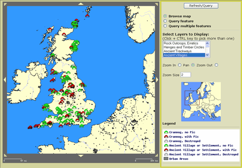
View of The new MapServer
Some Kudos and about the site:
The huge ancient site database with maps, news, community features “a wonderful guide” – the New York Times – “useful, fun, and accurate” – Archaeology Magazine. This independent web site is funded totally by their Online Shop http://www.megalithic.co.uk/shop
